Intro/Stats
Ferns Nipple (7065')
Unnamed 7100
George BM (7289')
12.7 miles RT, 4400' gain
From Grand Wash w/car shuttle to Golden Throne TH
Participants: Dwight, Dominic, Sarah, CP, Ed, Luba, Andy, & Kevin
Slideshow incl/Pandora's Box and Cassidy Canyons
CP invited us on a Capitol Reef trip exploring some canyons with a climb of Ferns Nipple thrown in. I had yet to visit this magnificent place and it did not disappoint. A challenging 11 hour day in a long slot canyon with some tight spots and high stemming called Pandora's Box left us pretty beat, but we recovered with a nice meal back at camp and were ready to see what Ferns Nipple would throw at us. I have included a link to a slideshow of the entire weekend. We topped out the weekend with Cassidy Canyon, a short buy inspiring canyon featuring 7 rappels. My camera lens was giving me troubles with the sand, otherwise I would have taken a lot more pics.
Ferns Nipple
There isn't a whole lot of beta on the web regarding Ferns Nipple. The easiest way in terms of climbing difficulty may be to take the Golden Throne trail to its end, then cross county to the north side of Ferns. Dow Williams describes a tough route going up a canyon on the n.w. side from Grand Wash. It involves some mid 5th class climbing. We started up this canyon around 7:30 or so in hopes of finding an easy exit on the west side before it got tough since we didn't have any pro with us. CP explored for awhile to no avail, so we decided to go back to the cars and head farther east up the Grand Wash.
Early morning views in the Grand Wash:
We drove to the end of the road, which is the trailhead for Cassidy Arch. Another report on the web describes a way to split the foreboding cliff bands and is described by a big dude with a walking stick. Surely we can find our way if the walking stick dude did it! We poke around for a bit and Sarah scores big, finding us a nice cairned route that zigs its way up and across ledges into Bear Canyon. It then crosses the canyon and heads southwest to a ridge due north of the summit of Ferns.
The route is well marked even though Ferns is not really advertised by the park service since it’s not what I would call a hike suitable for tourists by any means, albeit short. There are some scrambling sections, but nothing harder than easy 4th class. It zigs back and forth beautifully and brings us up to the northwest side of Ferns. We’re not sure what side is the easiest to climb on Ferns, but the n.w ridge looks like a possibility. Like Zion, everything looks steeper here until you get on it.
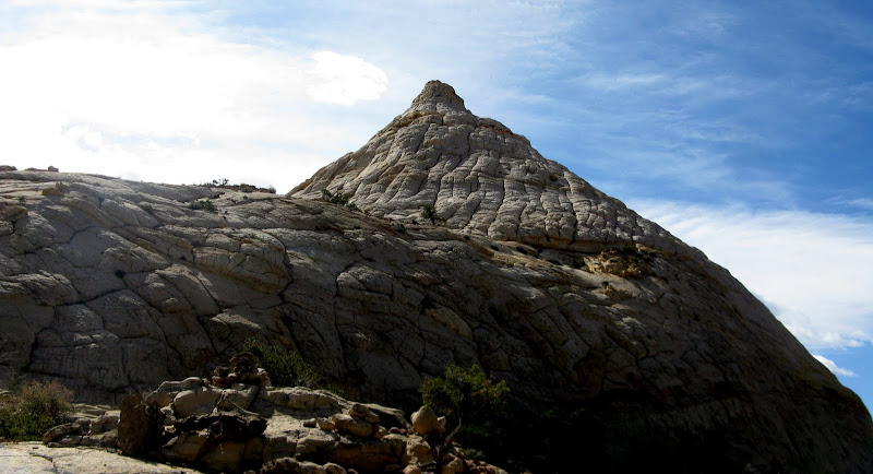
Ferns Nipple looking mighty perky:
The ridge lower down is loose sandstone in spots, but isn’t too exposed. The slickrock approach to the summit ridge is fairly low angle and easy, while the final scramble is exposed, but there are plenty of good holds to inspire confidence. The wind has picked up a bit. Fern must be getting mad! Only a couple 4th class moves are encountered and we are on top in a bit over 2 hours from our restart.
Sarah and Dominic on the summit ridge:
Ferns is indeed a classic climb and the trail we found worked out beautifully. I had wanted to add nearby George Benchmark and possibly Unnamed 7100 to the day if time allowed, and it was still very early. These peaks look pretty intimidating from Ferns, but CP had been up George and told us that it would go from here.
The Guessing Game
Unnamed 7100 & George BM from Ferns:
CP, Luba, Andy, and Ed decided to call it a day while the rest of us headed for the other peaks. We carefully made our way down the steep ridge, butt scooting or facing in on the crux. We then wrapped around the cliffs on the west side and made good time initially to 7100 cruising on easy slickrock. 7100 has a tower in front of it, and we weren’t sure which side to get around it on. We ended up contouring into a canyon on the east side of the tower, which ended up being a mistake as it slotted up and got very sandy and steep. We did have a 30M rope though, so Dominic checked it out but the terrain was just too sandy and steep to lead. We were an agonizingly .15 mile and two contour lines from the summit!
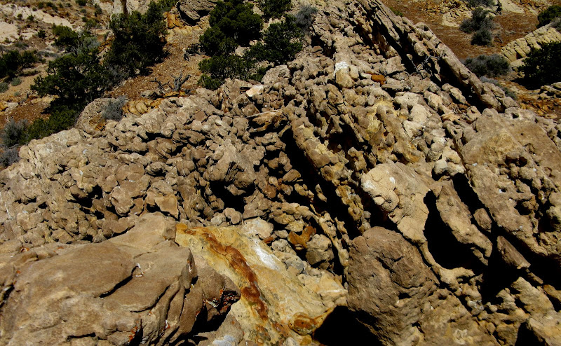
Nasty slot canyon:
We retreated and checked out another line out of the canyon. Dominic led and Sarah followed, but once again the poor quality of the rock and limited anchor options forced us to back off again. We retraced our steps out of the canyon and wrapped around to the west side of the tower, finding an easy slickrock traverse that brought us over to the west face of 7100. A nice ramp heading north across the face was our ticket to the summit, which was very cool, laden with weird moqui marble type volcanic rock. Very unique rocks up there, a rock lovers paradise for sure!
Big moqui marbles on 7100 summit:
George BM looked very intimidating from here, but we had beta from CP that it could be kept to a few moves of 4th class on the n.w. side and indeed it did. We stayed north and west of a deep canyon, then dropped down a short, brush choked gully that brought us to easy terrain. A short slickrock scramble gave way to a steep, loose, but easy walkup up the north slopes of George. Another very cool Capitol Reef summit! We’re now about 2 miles n.w. of the cruiser Golden Throne trail. CP has agreed to drop off a 4Runner at the trailhead, which makes it possible to do this grand tour. Easy meadows await us after we reverse our tracks down the slickrock. Should be a piece of cake, right? Little did we know what awaited us.
Ferns, the annoying tower, and Unnamed 7100 from George BM:
The meadow was a bit more tedious than expected as it was very sandy and choked with little balls of cactus with huge thorns. Sarah seemed to attract them more since she was wearing tights. I was worried I would get one in my foot since I had a big hole in one of my trailrunners on the side! Somehow, I came out unscathed.
The map we had for the hike didn’t include George or the Golden Throne trail, so we would have to hunt around for the trail. I spotted what was marked as a road on my GPS and wondered if that was the actual trail. That ultimately ended up being the million dollar question that cost us a couple hours. We dropped down into a drainage and picked up a cairned route that would take us to the left side of it. It didn’t match up with the beta we had though, which was that the trail was on the right side going down. We ended up heading back uphill in hopes of finding the real trail further west, thinking this was the wrong drainage. No dice!
We were now all out of water and it was starting to get late. We were worried about getting benighted in the great Capitol Reef, but never fear, we had fire chief Dwight with us! We gave up on heading further uphill and headed back down to the same drainage we started at, although now we were way below the ledges that the little cairned route crossed. Hey, there’s the scenic road below! Only problem there’s a huge dryfall in the way! The “road” that I saw on my GPS is now only .1 mile on a shelf above us to the south, but it meanders forever south before going the way we want to go. Doesn’t seem like an appealing option. Cliffs extended way north, but we scoped then out anyway in hopes of a weakness. Uphill we go again and energy is waning. No dice again.
I suggest we just go for the road and hope the official trail cuts across it at some point. Back to the dryfall we go and up the shelf we go. A grungy chimney climb is testing our resolve, but we press on. My waypoint for the end of the “road” ends up being the end of the Golden Throne trail! We’re in the clear finally and plod down the final 2 miles of the day. The Golden Throne trail offers some world class views and is beautifully constructed, but we’re too wasted to enjoy it. We’re back at the car at 6:30 and each chug a bunch of water. A grand adventure indeed in Capitol Reef!
Mighty Golden Throne:
Our convoluted GPS track from Dwight:


Comments
Post a Comment