Fore-Words
I (WWBF) originally had a prior commitment for Friday night. Therefore, I planned on leaving my house Saturday morning to drive to the Adirondacks. I’d hike until around 7:00 pm, then camp, and return home the following morning. I would spend as much time as possible on an exposed ridge, in order to “practice” for my planned trip up Mt. Washington in a couple of weeks.
The way things turned out, weather canceled my Friday night commitment. I was invited on a hike that would entail summiting Wright, Algonquin, Iroquois, and Marshall, then returning the way we came. The former two are trailed; there is a herd path to Iroquois; we would need to bushwhack down to the Iroquois-Marshall col; then take a herd path up Marshall. So it would be no easy task, especially with the new snow that was falling.
Since this trip was a last-minute decision for me, I left my house at 7:30 on Friday, and arrived at MudRat's house at around 12:30am. The trip usually takes just under 4 hours, but I hit some nasty lake effect on Rte 8, and had to bail south to the Thruway.
Wright
WWBF:
After a whole 4 hours of sleep, MudRat and I donned our gear and headed to Heart Lake where we met the rest of the group. The temperature was about 0-5*F. I felt fine until we started ascending the trail to Wright. My legs felt very heavy, and I was sweating despite having stripped layers. For me, it was a long slog to the Wright side-trail.
At the side-trail intersection I dropped my pack, and figured I'd feel fine ascending the summit... but that was not meant to be. My legs still felt heavy, but the adrenalin of alpine summit weather got me though. The temperature was about -5*F, and winds around 30 mph. A majestic snow-capped Whiteface dominated the northern horizon. At that moment, I realized I'd left my camera my pack at the intersection.
MudRat:
Our day started at 7:10 as we left the Loj parking lot. The loud crunch of a half dozen hikers wearing MSRs chewing into the icy trail broke the early morning tranquility. The sound, only slightly more annoying than nails on a chalkboard, awoke my senses. I led the way to the Algonquin/Marcy intersection awaiting a stab at some early morning hiking humor. WWBF and I made a confident hard left and walked a dozen or so yards toward Marcy Dam. Neil and crew ground to a tentatively slow halt. The quizzical look on Neil’s face as he approached the sign was worth the extra steps as WWBF and I broke into laughter.
Farther along at the intersection to Wright, we dropped packs and started the first assault of the day. The lightened load felt nice and we ascended in less than 20 minutes. The wind was at our back as we ascended the rime toward the summit. The aggressive crunch of the snowshoes biting into the ice now sounded nice. I wouldn’t be slipping this day. 9:30 a.m. found us at the summit where I spent nearly 30 whole seconds admiring the surrounding beauty and Algonquin’s face. As Neil mentioned, it was a good equipment check. The wind struck as I turned around to descend and the sliver of exposed skin on my face lit up like fire…a paradox since it was about –5 not accounting for wind chill. I remember the hood on my jacket sounding like a kite making a hard turn into the wind.
Algonquin
![Wright from Algonquin]() Wright
Wright
Back at the intersection, I figured I'd summit Algonquin and bail on the remainder of the hike. My pace was only hurting the rest of the group. I hate that feeling. However, I actually felt fine going up the steep slopes of Algonquin. Atop the sheltered ridge, I changed into summit gear, and snapped a couple photos of Wright.
On the exposed summit cone, I felt my fingers turning into sausages, and knew that I would have to don my overmitts on the summit. Time passed quickly, and I soon found myself standing on the summit. Lenticular clouds hovered above many of the visible summits, which all appeared to be covered in confectioner’s sugar.
![Whiteface from Algonquin]() Whiteface
Whiteface
A couple minutes later, Alistair arrived and joined me on the summit. Several minutes later, there was still no sign of Alistair's cousin. He went down to check on him, while I remained on the summit. Alistair arrived back on the summit, and said his cousin was still ascending, just slowly. He also said that they would turn back after his cousin summited. I told him I needed to catch up with the rest of the group, and we said our goodbyes.
![Alistair Descending Algonquin]() Alistair Descending
Alistair Descending
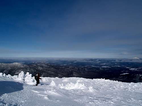
Back at the intersection, we performed our respective gear changes and prepped to climb Algonquin. Slow and steady was my mantra…just enough to warm my extremities. The tactic didn’t work well and I recognized that my body wasn’t working efficiently, probably due to the GI issues I had the night prior. Our group thinned into 3 separate groups as I topped Algonquin about 10:30 or so. Neil, Glen, Fred and Adonis disappeared from sight long before the top so; I ascended solo between them and WWBF, Alistair and his cousin. (I think that was everyone, apologies if I’m leaving out a name). I readjusted my facemask and goggles to extinguish the small cold “fires” I felt on my face once again. The views were breathtaking as I walked over the summit, hesitantly waited for the others which were still not in view. I saw Neil as a small black spot nestled in the trees below.
Iroquois
![The Gang on Iroquois]() Discussion
Discussion
Upon descending the back side of Algonquin towards the col between Algonquin and the un-official peak, Boundary, the wind occasionally blew through the “air-holes” in my balaclava and I could feel my lips going numb. Thankfully, this sensation instantly ceased when I changed my direction. The winds were around 40 mph. Any exposed flesh felt like it was on fire, and I found myself making constant small adjustments to my hat, balaclava, and googles. I soon reached MudRat in the trees, and we continued over Boundary and met the group in the Iroquois col.
Due to the deep snow and endless spruce traps, the going was slow in the col. Painfully slow. Literally. Once we broke out of the trees, we ascended the treeless summit without further difficulty. While I snapped some photos from the summit, the group had a discussion regarding whether or not we should continue on.
![Colden from Iroquois]() Colden
Colden
Just as I put my camera away, I was told the consensus was to head back. I wasn’t feeling bad at this point, but I wasn't I about to protest.
MudRat:
Once in the protection of the trees, I refueled. The area was alight in a skirt of bright white. The gently curving landscape, riddled with winter’s rime sculptures, connect Algonquin and Boundary. Their frozen branches offered the only warmth in the subzero temps…and it felt warm by comparison to that which I just left. My core, protected only by a summer rain jacket and a single wicking layer, felt perfect, though I did put on a primaloft jacket to keep warm without exertion doing its part. My hands and feet were still a problem and getting worse. It’s the first time in years that my toes were cold. The little voice in my mind kept telling me to monitor what my body’s signals in light of what our goal was. The bushwhack to Marshall was beginning to mildly concern me.
WWBF and I caught up to Neil and friends trudging toward Iroquois in unexpectedly deep snow. The unconsolidated mass was a perfect breeding ground for the first spruce traps of the season. The little devils were hungry. I waited in line getting a little cooler with each slow footstep until my turn at breaking. It felt good to exert a bit until I lost the way. Glen then passed me while I was extricating myself and continued. Up atop the ledges I got mired once more requiring help from Neil. Both show shoes were under branches and I was up to my armpits in unsupportive snow. Neil’s ice axe gave me the leverage I needed.
Iroquois’ summit fell underfoot at 12:30. Neil and the “Grasshopper” were consulting on the route past the Shepherd’s Tooth. They asked my opinion and I knew that I’d reached my safe limit. The bushwhack down through more of the same traps and subsequent bushwhack up Marshall, then back up Iroquois, Algonquin and Wright to top off our goal didn’t feel like the safest choice given the time of day, promised lows near -15 w/o wind chill and my own internal shortcomings. We collectively agreed to re-ascend Algonquin and head out. It was a wise choice.
The Hike Back and After-Words
![Algonquin from Iroquois]() Algonquin
Algonquin
Algonquin had a totally different look from near treeline on Iroquois.
My legs felt heavy again going back up Algonquin. Very heavy. I also felt like my balaclava was suffocating me. It reminded me of Into Thin Air, when Krakuer described how climbers would rip off their oxygen masks, feeling that they were suffocating them. Today, the backside of Algonquin was my Everest. However, with a slow but steady pace, I reached Algonquin’s summit for the second time today.
I followed Neil off the summit, but soon realized he was heading directly for Colden, instead of Wright. After I signaled him to take a hard left, we were soon back on the trail and then in the safety of the trees.
Descending towards the Wright intersection, I again was the slowest of the group. But this time I blamed my snowshoes. They are MSR Lightning Ascents, and although they are extremely grippy, that also means they don't glide. At all. Thus, they take me out of my normal stride, especially on descents.
At the intersection with Whale's Tail trail, I strapped my snowshoes to my pack, and barebooted the remainder of the way back to Heart Lake. I had no difficulty keep up with the group.
The following day, I was surprised how sore I was. It's been a very long time since I've been sore after a hike. This one really laid a hurt on me.


Comments
Post a Comment