
|
|
Route |
|---|---|
|
|
42.05694°N / 80.12440°E |
|
|
Mountaineering |
|
|
Summer |
|
|
Expedition |
|
|
UIAA I-II, 50° |
|
|
Overview
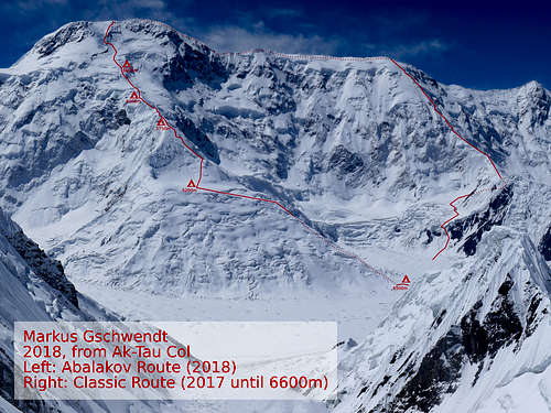
The abalakov route takes a very straight line from the north.
The face is broken in some obvious sections:
- a buttress with a plateau
- a triangle
- a horizontal ridge
- a band of seracs
- the lower summit wall
- a rock band
- the upper summit wall
Preacclimatised it should be possible with 4-5 camps in alpine style.
Getting There
Start at the regular Khan Tengri basecamp where you can walk in in several days or arrive within half of an hour by helicopter.
Normally the route over the glacier is marked with flags as the approach is the same as for the classic route.
Route Description
Approach
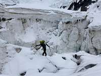
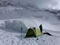
Usually the camp one is made at the foot of the buttress. Its one day hiking over morain and zig-zag over glacier. Its easily possible to split this up in 2 days or carry some gear on an acclimatisation day which is a good idea to check out the best way over the heavily broken glacier.
Buttress with a plateau
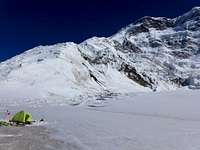
Stay on the North-West corner.
It can be tricky to find a passage on arriving at the plateau. Many crevasses.
Cross the plateau to the east until reaching the base of the triangle.
Do not camp to close unter the wall of the triangle - we had avalanches and broken seracs/cornices there.
Triangle
The first wall of the triangle can be climbed at the east corner or west of the center. Be careful about avalanches and falling ice blocks!

Then follow the ridge left or the steep face right of a rock scattered face. We had very deep snow here - take care!
After this you will arrive at a huge cornice which looks difficult from the distance. In 2018 it was rather easy to cimb it on the east end through a snow filled gully
It is possible to camp below or above this cornice.
Horizontal ridge
Just follow the ridge until a flat campground below a rock tower.
This ridge is dangerous! Most time easy walking with some short steps where belaying is a good idea. Big cornices on the east , sometimes extremly steep faces to the west and crevasses will call for attention. I broke a several meter long cornice on the way down.

The rock tower is about 60m easy climbing (UIAA I-II) on the right side. Some fixed ropes further left are from abseiling.

A short ridge leads to a flat space followed by a slope (slightly to the west) until a band of seracs.
Band of seracs

The ice was quite soft and finding a passage was easy in 2018.
As i believe that this part is changing it will be hard to give reccomendations wher to cross it.
We could not find a flat spot above the band but with some digging it was possible to set up the tent at 6600m.

Lower summit wall
Climb the wall straight up until reaching rocks at 7000m. The rock band will be to the east here.
Rock band
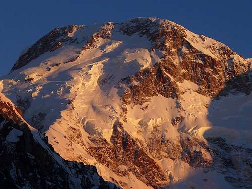
A obvious rock band splits s-shaped the summit wall. Horizontally starting from the lower east it is then leading straight up in the middle of the face and reaching the summit ridge further west.
At 7000m it is possible to cross the rock band without difficulties to the east.
Upper summit wall

After crossing the rock band climb the wall straight to the summit ridge. Stay to the east if possible to reach the main summit more directly and avoid the last cornice and horizontal summit ridge (~300m)
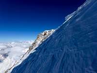
The real summit is to the east! On many pictures the Summit is marked wrongly to the west (eg the drawing on the main page). People from the classic route believe in the west summit.
Essential Gear
- All the warm clothes...
- Camping gear, food, gas,... for 1-3 weeks - depending on how long you are willing to wait in case of bad weather
- Shovel
- 2 Ice axes (1 axe if you really know what you do)
- Crampones
- Helmet
- Rope, Harness, Carabiners, Slings
- Partner
If you don't do alpine style (like we did) you might need extra ropes, anchores,...
External Links
The true summit location of Peak Pobeda - Eric Gilberrtson 2023
Markus Gschwendt 2018, 2023