
-
 2326 Hits
-
 75.81% Score
-
 6 Votes
|
|
Canyon |
|---|---|
|
|
38.61276°N / 23.79963°E |
|
|
Hiking, Trad Climbing, Toprope, Big Wall |
|
|
Spring, Summer, Fall, Winter |
|
|
Overview
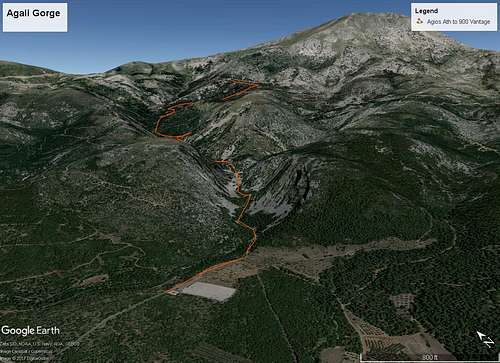
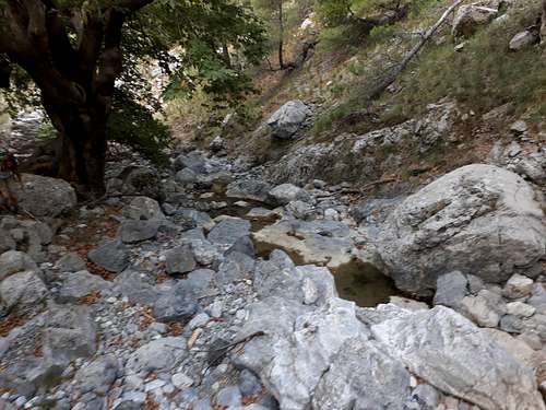
Agali Gorge is located on the western slopes of Mt. Dirfi, just under the massive 1743m peak. The main gorge is 4.6km long and is one of the two main river systems on the west of Dirfi. The gorge begins on the shoulder of Dirfi that connects to Pixarias mountain at approx. 1200m of elevation and finishes (i.e. opens to the palins) at 200m of elevation. The gorge has on main trail with one vartiation, the first trail heads up or down the gorge and the other variation allows you to exit the gorge and traverse the western slopes of Dirfi towards the HMA refuge.The river passing through the gorge is seasonal and needs to be crossed 6 times during the hike, sadly two of the bridges have collapsed so might be unable to cross the river during high season (late April to late May). The gorge is home to three spring that will be detailed bellow.
Getting There
You can either hike top - bottom, or bottom - top. The bottom of the gorge is located 2km outside of the village of Agios Athanasios. The top is the Itamos refuge (or about 20 mins of hiking away). Here are the directions:Both of the direction markers are a bit behind the actual trail head. Both of the acctual trailheads a bit more of a drive. On the bottom trailhead a football field marks the TH, on the top a refuge markes the TH.
This is the bottom to top description
The trail follows the river (on the river level) for approx 2km, and crosses the river at the pre mentioned 6 bridges. Four of those are up and are newly build steel bridges; there are two more (the two final) that have been destroyed and were wooden. After following the wide (car sized) trail up to the two final bridges, you will already have reached the first spring; then the trail rises from river level and reaches a vantage point (at around the 1 hour point).
The trail from there climbs upwards through the dense forest up to Kratia spring (860m) where the trail splits. You can either hike west through a large forest road where after a 3-4h you would reach the HMA refuge. The other choice is hiking N-NW (heading 270-340) behind the spring; the trail from there becomes steeper up to 900m of elevation where it meets a forest road and a stone bench vantage point with sick views down towards the gorge you hiked. From there you can either hike down or hike the forest road N towards the Itamos refuge on the shoulder.
- Distance: 5.41Km (one way)
- Time: 2:30h
- Vertical Gain: 951m
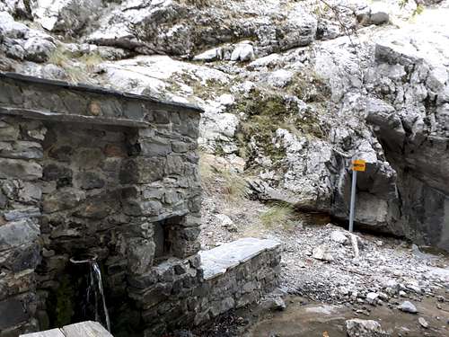
You can get water on the hike at the Kratias spring (2h in) so prep, accrodingly. Furthermore it is a great route to hike in hot weather since if you hike in at around (7:00 - 7:30am) you will be under the shadow of Dirfisfor the entire hike.
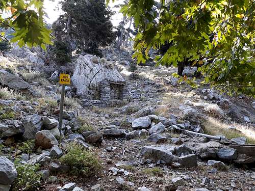
Springs
The mountain gets a lot of snow, so obviously the river and mountain has a lot of water. On the hike you will encounter two springs and one more that is a river side spot where you can refil your bottles.
The springs are:
Αρκουδοβρυση, /Bearspring/ at 397m of elevation and around 45mins through the hike. This spring is the riverside spot.
Κρυα Βρυση, /Cold Spring/ at 397m of elevations and is 2mins away from Bearspring.
Πηγη Κρατια, /Kratia Spring/ at 860m of elevation and is 2h in the hike, it is the final spring and has the 'purest' water.
Arkoudovrisi
Kratia Spring
Kriavrisi (Cold Spring)