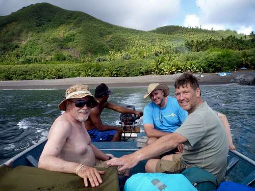
The team started with RK, JM and CK. To spread the cost of chartering the boat between Saipan and Agrihan we sent out emails trying to entice others to join the team. In the end we had a group of 6 climbers: RK, JM, CK, RW, MB, JD and a photographer LT.
Preparation
In February/March we started planning the trip in earnest. We first looked at how we would get from Saipan to Agrihan - some 250 miles north of Saipan. We checked with AmeriCopters (http://www.americopters.com/en/) but decided the weight restriction (400-500 pounds at that time) and cost (US$20,000+) would be prohibitive.
We also looked for passenger vessels operating out of Saipan using
http://boatdb.net/port/saipan-mp.htm. While many boats are listed, we quickly found many are too small to carry several climbers and their gear/supplies. Several other boats are restricted to stay within 20 miles of Saipan. It turns out there are only a few boats which are large enough (60 feet plus) and US Coast Guard licensed to travel to the northern islands. We contacted several boat operators including Blue Marlin, Kaiyu III and the Super Emerald asking what facilities they have, how long it would take to travel to Agrihan and how much it would cost. We ultimately decided to charter the Super Emerald which is a former ferry boat. It seemed to have the best facilities and appeared to be the most comfortable. It has two toilets, a shower, a large air-conditioned interior with benches to sleep on and plenty of storage space. The upper deck is also rather large for communal eating and relaxing.
In parallel we wondered whether we needed permission to land on Agrihan and climb it. Up until 1990 Agrihan had been inhabited with several families living in a small village on the southwest shore. We contacted the CNMI Congressional Representative and he put us in contact with the Office of the Mayor of the Northern Mariana Islands Municipality (NIMO). Their mail address is P. O. Box 10007, Saipan, MP 96950. In 2015 the Honorable Jerome Aldan was the mayor and the administrator was Lee Kaipat
(670) 664-6466
Talking with them we found we needed to complete two documents. The first is a Mayoral Authorization for Entry (MAE) to the northern islands (primarily Agrihan and Pagan). Completing the form we listed the Highpointers Club as the lead organization with the stated reason for entering Agrihan being the promotion of reaching some of the highest mountain peaks in the Pacific. We provided full contact information for each climber as well as our entry dates (May 28 - June 6, 2015 - more on this later).
The MAE requires that we obtain all necessary licenses, permissions, etc. For example, US Coast Guard, Fish and Wildlife (there are endangered animals on the northern islands), etc. This is where the second document, a Limited Power of Attorney (LPA), was important. The team leader completed this form which allows the mayor's office to interact with all other government agencies on our behalf and obtain those necessary permissions. The ship's operator also interacted with the local agencies.
Corresponding with both NIMO and the Super Emerald as well as looking at long-term weather forecasts, we picked a window for climbing Agrihan. The general consensus is mid-May to end-July is the best window. It is after the winter winds so the seas are calm enough for the 20-22 hour crossing from Saipan to Agrihan. Yet it is before the fall storms batter the area.
Based on previous island summit climbs, we decided to charter the Super Emerald for 10 days. We estimated it would take 4-5 days to hack our way up from the beach to the western summit. Plus 1 day to traverse to the eastern peak. Plus 1-2 contingency days for rest or bad weather. Plus 2 days for transit between Saipan and Agrihan. Working with the team of climbers and the boat operator we ultimately chose May 28 - June 6 to charter the Super Emerald.
We scoured the internet for information on Agrihan. We found several pictures, some videos and of course satellite photos. Looking at these we determined at least half the route would be through sword grass. Us mainlanders were not going to start using machetes to cut our way up. Working primarily with the boat operator but also with NIMO we decided to hire 5 locals to support the team of 6 climbers: Omar, Patrick, Vince, Tony and Lawrence. The idea was to have a team of 3 cutters and 2 supply carriers who would rotate duties throughout the day to rest their arms/legs respectively. Unfortunately, this idea didn't work out. The supply carriers stayed with the cutters instead of descending and carrying up new supplies for the team. Some of the climbers ended up ferrying the supplies up the mountain.
May 26-27, 2015 - Saipan - Preparation
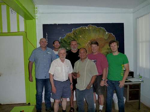
Over the last day or two the climbers have been flying into Saipan. We arranged for two meetings during this time. The climbing team meets with NIMO to sign and exchange the final MAE paperwork. We also meet with the Super Emerald boat crew and the local team of cutters and carriers. We are given permission to load our supplies on the boat in the evening. This mostly consists of water (roughly 5 liters of water per person per day) along with food and camping gear.
![Saipan mayor]() The climbing team meeting at the Northern Islands Mayor's Office with the Honorable Jerome Aldan
The climbing team meeting at the Northern Islands Mayor's Office with the Honorable Jerome Aldan![Saipan boat]() The climbing team meeting with the captain of the Super Emerald
The climbing team meeting with the captain of the Super EmeraldMay 28, 2015 - Saipan to Agrihan
We had arranged to leave the harbor at 06:00AM. JM makes two shuttle runs from the hotel to the harbor starting at 04:45AM. We cast off at 06:15AM to start the long 20-22 hour journey to Agrihan. Almost everyone takes some form of seasickness pill. Many people sleep, talk and generally relax during the day. Us mainlanders are getting over jet-lag as well. While the boat is in motion, there is no cooking. Lunch involves Spam and rice (prepared ahead of time) and fresh sashimi. Several locals are trawling fishing lines as we motor north and catch several fish as we go. Around 18:30PM we stop in the lee of Guguan island for a couple of hours. We have the wind behind us so we are ahead of schedule. The boat crew prepares a dinner of pork, rice and more sashimi. After a couple of hours we head out again and continue the journey to Agrihan.
![Guguan dinner]() Dinner of pork/rice and fresh sashimi in the lee of Guguan
Dinner of pork/rice and fresh sashimi in the lee of GuguanMay 29, 2015 - Agrihan
We start waking up around 05:30AM to low clouds and a gloomy sunrise. We can see Agrihan in the distance! We anchor near the beach on the southwest shore near the abandoned village. A 12 foot aluminum skiff is lowered into the sea. With several skiff shuttles the 5 cutters, 6 climbers and all our supplies are on the beach by 06:45AM. The general plan is for the local cutters to set out and mark a trail during the day and return to the beach in the evening to sleep and have a nice dinner. The mainlander climbers will stay on the beach and along with the boat crew establish a comfortable beach/base camp. This allows the mainlanders to recover from the boat journey, sea sickness, jet-lag, etc.
![SW beach landing]() Shuttling between boat and shore with climbers/supplies
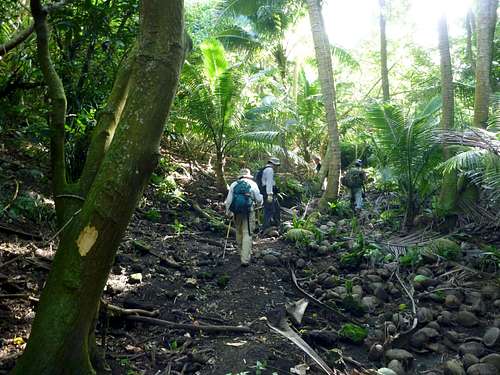
Shuttling between boat and shore with climbers/suppliesAround 07:00AM the 5 locals and CK set out and reach the village by 07:30AM. This short section has the most undergrowth and takes awhile to mark. Once we regroup we continue up through dense coconut palm forest. We cross over a low ridge to a valley and follow a dry stream bed for awhile before heading up an increasing slope to reach the forest - sword grass transition zone. We reach this zone around 11:30AM and the 5 cutters drop most of their water (many 2 liter bottles) here. So much for them caching the water high up on the mountain. After a lunch break we head out and cut our way over a small 4 foot headwall of rock/soil. Once above the headwall we encounter a solid wall of tall (6 feet) sword grass ;(
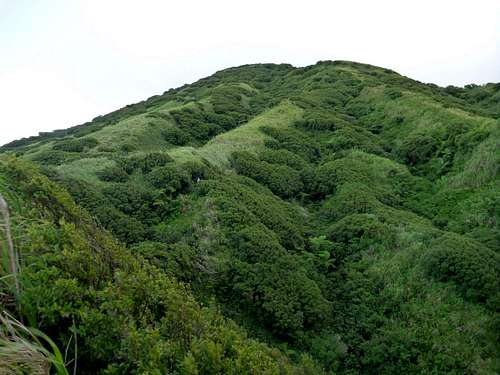
![lower forest]() The lower 1/4 is covered in mostly coconut palm forest
The lower 1/4 is covered in mostly coconut palm forestThe rest of the afternoon is spent cutting our way up towards the ridge line in a diagonal line. At one spot we are forced to drop down and traverse before continuing upward. We aim for a clump of trees on the ridge line and reach them around 16:30PM. Now that we are on the ridge line, hopefully things will go faster. We drop a small water cache here. The 5 locals continue cutting upward while CK starts descending to the beach. The locals soon catch up and we find our way along the well-marked
trail to the beach camp which we reach around 19:15PM.
May 30, 2015 - Agrihan
JM talks with the locals as they head out around 06:15AM. They agree to reduce the frequency of their rest stops in order to increase the pace. The climbers slowly head out in pairs around 07:00AM, each carrying a 6-pack of 2L water bottles. The plan is to cache them up on the ridge, relieving the locals from having to carry the water. This way the locals can focus on forward/upward progress today.
The climbers regroup and rest at the tree/grass line before scaling the headwall and entering the sword grass. Without tree cover the fierce sun and high humidity quickly slows the climbers down. With several rests we reach the ridge line around 11:30AM. The last steep uphill really saps the energy from everyone. We cache the water and rest awhile. JM, RW, JD and CK eventually continue on to catch up with the cutting team. Unfortunately we reach them rather quickly. It doesn't appear they have made much progress in the roughly 4 hours they were on their own. They quickly jump up and start working when they see us approaching. We follow along until they reach another patch of trees at 13:00PM. The mainlanders drop all their water here and most turn around to head back to the beach. It is decided that CK will stay on the mountain and camp with the local cutting team.
![middle sword grass]() The middle 1/2 is covered in dense, high swordgrass (6-7 feet / 2 meters)
The middle 1/2 is covered in dense, high swordgrass (6-7 feet / 2 meters)JM, CK and Joe each have a small hand-held family radio so we can communicate with each other - usually in the morning and the evening. This allows the entire team to keep updated with status and location reports, discussions about what supplies are needed and if needed (hopefully not) emergency rescues.
The cutting team continues working upward while CK ferries water up the mountain. The idea is to leave a 6-pack of 2L water bottles at shaded spots about 1 hour apart. This way when the main team leaves the beach they only have to carry food and camping gear and very little water. They can replenish their water bottles along the way - both going up and down.
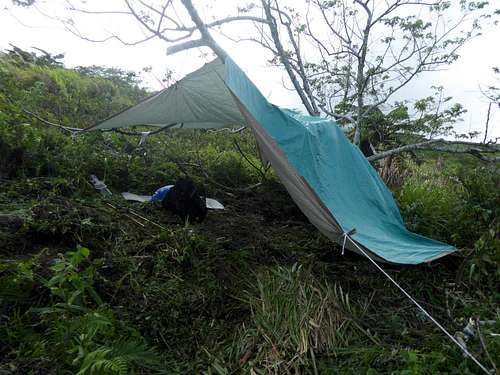
The rest of the day is spent like this. Fortunately clouds come in and cut the fierceness of the sun. The cutting team makes good progress and reaches a giant fern patch in the early evening. They setup a giant tarp hanging from a semi-dead tree around 18:00PM at an altitude of 1980 feet. They manage to light a fire in the breeze and cook crunchy rice. CK gives them some left-over food which the locals quickly devour. It appears they have underestimated their water and food needs ;(
![base camp]() We were lucky to find a fern field for our base camp around 1980 feet / 603 meters
We were lucky to find a fern field for our base camp around 1980 feet / 603 metersMay 31, 2015 - Agrihan
CK and the locals wake-up around 06:00AM and start work by 07:00AM. While CK slept fine in a bivy sack, the locals found it cold and shivered a lot inside their blankets. The night-time temperatures are around 75F but it is breezy. Hopefully we can find extra clothing for the locals to wear at night so they stay warm. It will only get cooler and windier the higher up the mountain.
The general plan is the locals will continue cutting trail throughout the day. They will then return to this base camp for the night. Meanwhile CK will continue bringing water from lower down and staging it at the base camp. At 10:00AM CK makes a radio call down to the beach camp asking for more supplies - water, food and extra clothing for the cutting team. Fortunately RW hasn't left the beach yet. RW repacks his backpack with food/water for the locals along with his own food/water and camping gear. He plans on climbing up and staying at base camp tonight as well.
Things progress through the hot afternoon. During the 14:00PM radio call Joe says that the locals are making good progress and will not return to base camp. They would like CK to bring food/water and the large tarp up to a new high camp. New plans are hatched so that RW can catch up to CK - which he does around 15:00PM. After transferring the cutter's food/water to CK, CK sets out for base camp where he will gather the camping gear and continue up to the new high camp. The locals have made excellent progress and established a high camp at 2570 feet along a ridge line. The sword grass is shorter here and progress has been easier during the late afternoon. The locals love all the canned food (Spam and Dinty Moore stew) and water. The 20:00PM radio is all good news. It looks like the locals will reach the western summit tomorrow! The rest of the climbing team can leave the beach camp and come up to base camp tomorrow. The only issue is bringing up more water to support 11 people while we investigate the western and eastern peaks. We decide to hire two more locals who will each carry a 6-pack each up to base camp for us.
June 1, 2015 - Agrihan
Even though we are scattered over the mountain, everyone seems to wake-up around 06:00AM. The beach team (JM, RK, JD, MB) leaves soon after, while RW leaves base camp around 07:00AM and the locals leave high camp around 06:45AM. CK waits at high camp for RW to arrive. They will then split the load of food/water for the cutters and take it up to them. RW reaches high camp around 08:30AM and with CK reaches the cutters around 10:30AM. The adrenaline and excitement are growing - we might even reach the summit before lunch! At these higher elevations the sword grass is knee to waist high with smaller stalks for easier cutting. There are also several patches of trees which make for easy, if slippery, progress. With the blustery wind there aren't even any gnats ;)
![upper slopes]() The upper 1/4 is a mix of stunted trees and knee/waist-high swordgrass
The upper 1/4 is a mix of stunted trees and knee/waist-high swordgrassWe are walking along a narrowing ridge towards the crater rim. To the east we can see the eastern summit from time-to-time as the clouds pass. The traverse doesn't look that easy - a very thin crater rim which is fractured at spots. Fortunately RW has a hand level so we can look across and determine which peak is the highest peak. Around 11:00AM the cutters let us pass so we can walk the final part of the ridge to the western summit. NOT. About 150-200 feet before the summit the ridge simply stops. There is a 40 foot vertical to slightly overhanging drop before the ridge continues toward the summit ;( AARRGGGGHHHH. So close, yet so far away :-( Our GPS reads 3140 feet. Upon arriving home we asked a geologist about this drop and were informed that the crater wall is probably separating form the ridge prior to falling into the crater.
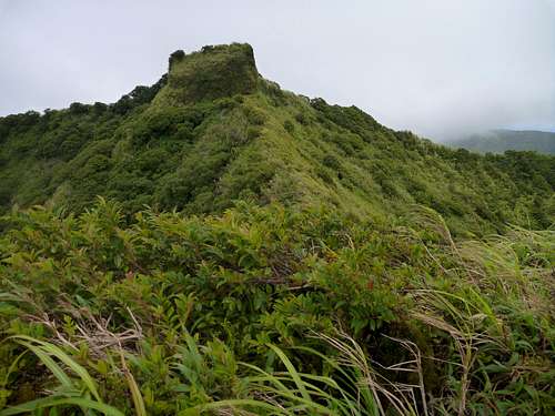
![western summit]() The western summit block - with an unclimbable 40 foot break between us
The western summit block - with an unclimbable 40 foot break between usMaking the noon call to the upcoming climbing team was not fun. After 3.5 days of effort we have reached a dead-end. While JM is carrying a short climbing rope, there is no place to anchor it here on the narrow ridge. It is decided that the climbing team
will continue up, while we will slowly descend to high camp looking for an alternative route. Somehow find a way off this ridge line down into an eastern valley which we can then take directly up to the summit plug. We try a couple of locations which look promising, but the slope increases and appears to vertically drop into the valley below. Again something that cannot be passed safely with only a short rope for aid.
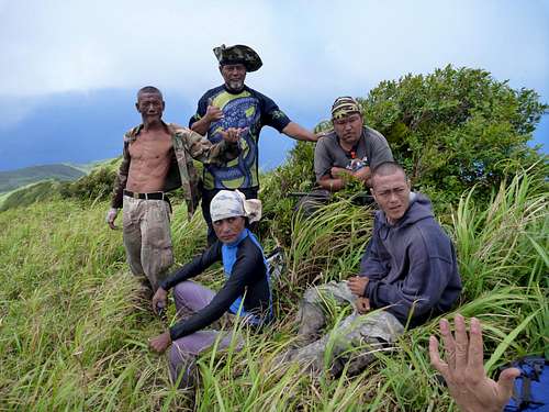
![Summit local support]() The 5 local support members near the attempt's high point who made all the difference in cutting a path through the dense sword grass
The 5 local support members near the attempt's high point who made all the difference in cutting a path through the dense sword grassAt 13:30PM the two teams of climbers make another radio call to update each other. The upper team reports that there doesn't appear to be another way to the summit plug from this high up. We might have to descend back to base camp at 1980 feet to find another alternative. The issue then becomes whether there is enough food/water for all 11 members for the next 2-3 days. The conclusion is that while the mainlander climbers brought enough supplies, the local cutters did not. Thus the conclusion is the expedition is over. The local cutters can return to the beach camp. The mainlander climbers will spend the night and "summit" tomorrow morning. All mainlander climbers meet at high camp around 15:45PM. JM and JD decide to climb up to the high point to assess the situation. Their conclusion as well is that it is a dead-end.
June 2, 2015 - Agrihan
After a windy and chilly night we wake up around 06:00AM. Groups head up to the "summit" at 3140 feet. The clouds are thick and it is hard to even see the true summit plug 150-200 feet away. We leave a summit register tied to a small tree and descend around 07:30AM.
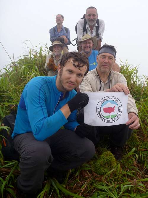
![Summit HP club]() The dejected mainlanders near the attempt's high point
The dejected mainlanders near the attempt's high pointWe break down high camp around 09:00AM and head down to base camp. Here we pick up some cached gear and continue our way down to the beach. By the time we descend to the lowest water cache the clouds have broken and the fierce sun beats down on us. It is a great relief when we enter the forest and its shade. After resting for awhile we continue down and reach the beach at 14:00PM.
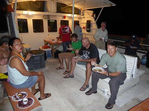
Some of the team swims in the ocean while the others lay down to rest. After awhile we start breaking camp and ferrying things back to the Super Emerald. We lift anchor around 16:00PM and head to Pagan which is 4 hours away. The shower aboard the Super Emerald feels great and the first cold beer tastes amazing as we cruise away from Agrihan.
June 3, 2015 - Agrihan to Saipan
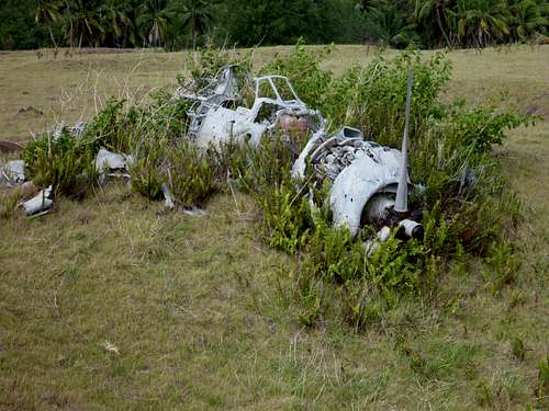
We anchored in a sheltered cove off Pagan last night. In the morning we shuttle over to the island and spend a couple of hours on the island. We get a chance to visit with the locals living there as well as wandering around. It is interesting to see some of the WWII relics and the bombed runway. Only an Alaskan bush pilot would dare land here now.
![Pagan wwii]() Several WWII Japanese planes can still be seen on Paga
Several WWII Japanese planes can still be seen on PagaWe reboard the Super Emerald around 09:30AM and cruise 4 hours south to Alamagan. One of the crew members used to live here and hopes to move back in the summer. They have several crops planted and there is a permanent water source which Agrihan does not have. We have a nice barbecue chicken dinner with delicious coconut flat bread ;) Some of us snorkel while others just relax in the shade. We return to the Super Emerald in the late afternoon and a couple of hours later have a great seafood dinner. After dinner we lift anchor and endure another 15 hours of rough seas to Saipan. The wind is against us so the going is slower and the waves bigger ;(
June 4, 2015 - Saipan
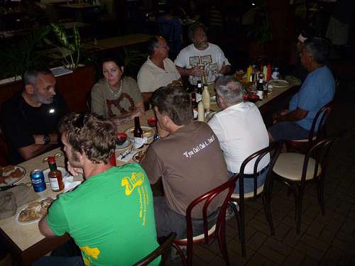
The rough seas sure make the return journey unpleasant. We eventually reach Saipan by mid-afternoon and are welcomed with a pizza dinner with Pepsi and beer. We celebrate the expedition - everyone is safe even if we haven't reached the summit. The locals believe we summited Agrihan while most of the mainlanders consider it a near miss.
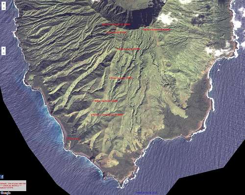
![Aerial view with waypoints]() Gmap4/USGS Aerial view of Agrihan with key waypoints marked
Gmap4/USGS Aerial view of Agrihan with key waypoints markedThe Super Emerald boat crew were very friendly and attentive to our needs. They did an amazing job cooking on board as well as making the beach camp as much a home as possible. The mayor's office was also very supportive of our efforts to summit Agrihan.
Dangers
- The lower slopes have been taken over by feral pigs which were abandoned in 1990 when the local villagers were evacuated due to increased volcanic activity. There are a few feral dogs as well. Monitor lizards can also be seen on the lower slopes.
- Your sanity is in danger due to the millions of gnats which infest the entire island, even the upper slopes near the summit. They are non-biting but a great nuisance until sundown when they disappear.
- Using a machete to cut the sword grass leaves many punji sticks which can be painful You may want to wear tight-weave socks (for the punji sticks) and leather gloves (for the leaves) to protect yourself.
External Links
Roger Wendell's (RW) web page with his photos/videos -
http://www.rogerwendell.com/cnmi.html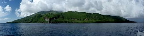


Comments
Post a Comment