
-
 11629 Hits
-
 75.81% Score
-
 6 Votes
|
|
Route |
|---|---|
|
|
47.12940°N / 11.91800°E |
|
|
Download GPX » View Route on Map |
|
|
Hiking |
|
|
Summer, Fall |
|
|
Half a day |
|
|
Medium hard hike up |
|
|
Rating The Tour (By Hiking Standards)

0. General. From 1960 m to 2976 m, exposition W and N. All the time marked. On the summit section there's quite some exposure and a safe step is needed. By the Swiss (SAC) Hiking Scale the rating would be T3. Gear (in dry seasons): Only good shoes and poles. Take care of already a high altitude! Even in summer you can find snow fields below the summit (none is steep) and if weather turns bad consider the possibility of snow or even ice on the summit ridge! In summer you will see that the majority of hikers is coming up in light shoes and without backpack with warm clothes in it. Can work in a 100% stable weather, otherwise not to be recommended.
1. Effort. 1100 m, 3 h 30 min.
2. Power. 1 - no difficulties, only walk-up.
3. Psyche. 3 - medium.
4. Orientation. 1 - no difficulties (all the time well marked paths).
The grading system for hiking and scrambling routes is here.
Overview
The main page of Ahornspitze needs some improvements; it's written much from the skiing perspective. As I don't have personal experience, allow me just to describe the most frequented ascent route which a big majority of visitors will experience.
Ahornspitze is a nice, high summit, dominating Mayrhofen, the centre of Zillertal Alps. It is one of the most popular summits in Tyrol, in the first place of course due to its great panorama and the high reaching cable way. There are two summits a few minutes apart from each other. The southern one is higher, on the northern one there is a cross and from it Mayrhofen can be well seen. Before building Ahornbahn, one needed to overcome on the ascent 2300 meters of altitude difference. Now the cable-car brings you 1960 m high and the ascent becomes a half day endeavor. Even more, in the middle of the route there's Edelhuette supporting the ascent. Besides the big panorama the rationale for the ascent can be also a nice hiking route, on top a bit spiced by some steep sections, which can be also combined in a round tour. I will not name the summits which can be seen from the top; at the end the summit was mostly in clouds when we ascended it. But in a nice day it's all the main Zillertal Alps summits, showing their glaciated side, and on the other side the view is completely open on Kitzbuehler Alps, Karwendel and other northern groups of Alps.
Getting There


See the page of Zillertal Alps how to get in Mayrhofen (you exit the highway through Inn valley in Jenbach). Ahornbahn is supposedly having the biggest cabin in Austria, so don't get distressed by crowds; visitors are being taken quickly.
Route Description


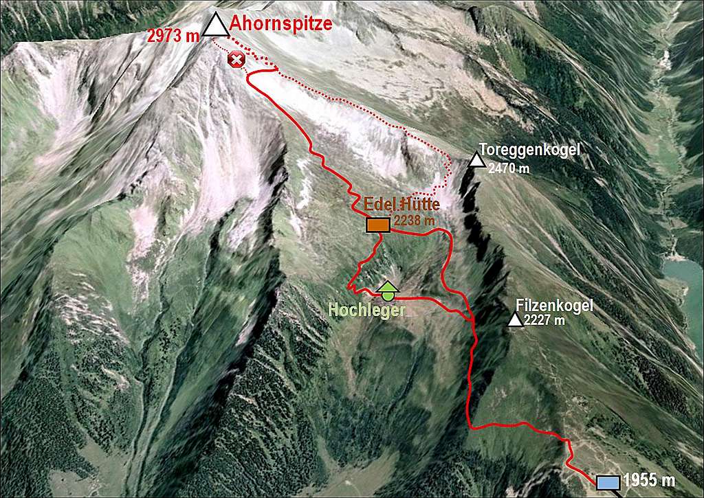
From the upper station you go across Filzenalm, now being transformed into a tourist circus, where many people go just a few hundred meters around by a path, enjoying some views and explanations of mountain features. In the upper part one steep path ascends up the grassy ridge on Filzenkogel, 2227 m, but our marked path goes left, into the northern slopes of that summit, in the beginning even descending a bit. After traversing the northern side ridge of Filzenkogel (broad path, but some care needed if hikers are inexperienced) the path continues horizontally and soon later ascending. It is broad and comfortable, suited for big crowds who attempt Edelhuette as their ultimate goal. You need to gain 300 meters till there. Before reaching the hut, the path crosses the creek in a broad turn and above the next bump there's the hut. 1 h 30 min till here.

Above teh Edelhuette

Below the upper ridge of Ahornspitze
From Edelhuette the well marked path ascends westwards. It is still broad, comfortable and well marked. In broad turns you gain altitude, approaching the western ridge of Ahornspitze. Then the path continues right below it in the upper part of Fellenbergkar (the rocky upper valley between the two Ahornspitze ridges). There, on some 2700 m, the path branches. All old descriptions advise as the normal ascent the path which continues straight up, finally ascending through a ravine the notch between both summits of Ahornspitze. In 2010 that route was closed (before, even if it's not hard, hikers were warned of rocks fall possibility), so the normal ascent route now deters right, traverses the upper part of the valley and ascends comfortably on Popbergschneide - the W-SW ridge of Ahornspitze.

On the W-SW ridge

Summit ridge
From the point where the now normal route reaches the ridge to the top the path is well beaten, but steep, requiring on several places a safe step. It goes in turns mostly by the ridge, finding best passages. If there are many visitors, some additional care is needed. For the last 200 meters you will need half an hour, from Edelhuette to the top 2 hours altogether. The path reaches now first the higher southern summit, the connection traverse to the northern summit is secured by a short cable. Descent can be done by the same route, or you can continue down by Popbergschneide. Going by this ridge was in the past highly recommended in order to do a round tour (because before the normal ascent went through the ravine). Now you did already the upper part of the ridge so perhaps you just want to go quickly down. The rest of Popbergschneide is a bit more difficult and exposed (also a few climbing passages of UIAA I difficulty). When reaching the saddle just before Toreggenkopf, 2470 m, you turn right (northwards) and descend directly to Edelhuette. Also on this route you should find marks. For the shortest descent route count 2 h 30 min to 3 h (important if catching the last cable-car drive), for the Popbergschneide count 30 minutes more. The continuation of the ridge to Filzenkogel (Filzenschneide) is even harder.
 The summit |
 The traverse between two summits |
 A window in clouds |