Trip Report
![Ingalls Peak from Ingalls Pass]() Ingalls Peak
Ingalls PeakThe Seattle Times newspaper has been running a series of articles in their Sunday magazine titled "Our Crowded Future" about the impacts of population growth on our quality of life. I was thinking about that while standing at the base of Ingalls Peak waiting in line behind four other rope teams to climb the South Ridge. On Ingalls Peak I discovered a new form of climbing that combines the crowds of a popular cragging destination like I-90's Exit 38 with the approach hike of an alpine climbing destination like the North Cascade's Black Peak. I call it "Alpine Cragging".
The day began before dawn in Seattle as an "urban alpine start" when my friend Jason picked me up at 5 a.m. It was the first weekend of fall, but the forecast was promising some fine Indian summer conditions—warm and sunny. With such good weather I hoped to do something ambitious, but it was a Sunday and Jason had to be at work early on Monday so he had one criteria—that whatever we climbed needed to have zero possibility for turning into an epic that would result in us getting back to Seattle late. So the plan was to climb Ingalls Peak, an easy, popular, and highly recommended climb in the Alpine Lakes Wilderness.
The drive started the day off well. After exiting I-90 past Cle Elum the directions to the trailhead led down the scenic Teanaway River Road through rolling forested foothills of the eastern slopes of the Cascades which were punctuated with the well-tended fields and pastures of picturesque farms and ranches. It was classic Western landscape and I half expected to see John Wayne riding a horse down the side of the road.
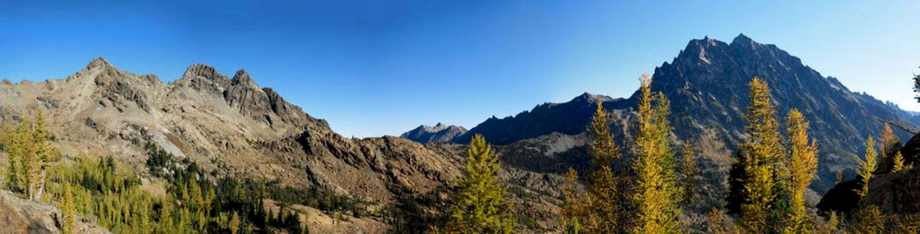
| Ingalls Peak and Mount Stuart Panorama from Ingalls Pass |
When we arrived at the trailhead I was shocked/appalled by the number of cars parked there. There must have been a zillion people there Saturday because there were cars parked far down the road from the parking lot and there was even a school bus at the trailhead. When we started the hike it was light out, but we were still in shade and could see our breath as we headed up the trail. I learned later from people who camped out that it had been both snowing and sunny at the same time on Saturday. It gave me some hope that we might have a ski season this winter.
The trail was in good shape. Not super steep and through dry forestlands of ponderosa pine and yellowed grasses. It was the kind of landscape seen in many Westerns and reminded me of the scenery in my all-time favorite Xbox 360 game, Red Dead Redemption. I really enjoyed the approach hike up Ingalls Way. At Ingalls Pass you cross into the Alpine Lakes Wilderness and from there you are only about five-and-a-half miles from Aasgard Pass, the western gateway to the Enchantments. The rest of the hike to Ingalls was like a little slice of the Enchantments: larches, mountain goats, rugged peaks, and high alpine lakes. There is no permit required for Ingalls and crowds there are a reminder why the Enchantments permit system exists. It is needed to keep the area from being loved to death like Ingalls is in danger of.
![Ingalls Peak in Alpine Lakes Wilderness]() Wilderness Area
Wilderness Area | ![Mountaing Goats and larches]() Ingalls Way Trail
Ingalls Way Trail | ![Ingalls Peak and Lake Ingalls]() Lake Ingalls
Lake Ingalls |
From Ingalls Pass we had a view of the Headlight Creek Valley. On the north side was Ingalls Peak and to the east was Mount Stuart. Usually features like peaks, lakes, rivers, and passes have names that are just someone's name or they are frontier-era names, but Ingalls Peak has some distinctly modern sounding names in its area: Headlight Creek and Lake Campfire Girls. Campfire Girls getting a lake named after them seem straightforward, but Headlight Creek sounds like a good story. I imagine a scenario like someone driving a jeep into it in the dark or something like that.
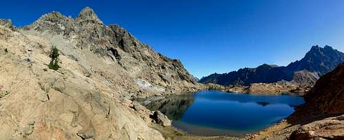
When we arrived at Lake Ingalls we paused to replenish our water and take in the views of Ingalls and nearby Mount Stuart. I had just finished reading Lord Dunsany's fantasy novel
The King of Elfland's Daughter so the dark blue-green waters of Lake Ingalls reminded me of the tarns (alpine lakes) of the mountains of Elfland. Although out of print and largely forgotten Lord Dunsany was an influence on many writers like H.P. Lovecraft, J.R.R.Tolkien, Ursula K. Le Guin, and Neil Gaiman, just to name a few. I only found the novel through a chance discovery at a used bookstore of an old Ballantine Fantasy paperback edition. His writing is some of the most poetic prose I have ever read in a fantasy novel. There is a theme that Dunsany uses over and over again in
The King of Elfland's Daughter about travelling "Beyond the fields we know." It is a great metaphor for adventure in general and applies well to mountaineering. From the introduction "Most men were content to stay within the fields we know, listening to the tales of the restless ones who travelled and brought back visions of strange places and stranger times."
![Ingalls Peak North Peak]() North Peak
North Peak | ![Serpentinite Rock on Ingalls Peak]() Serpentine Rock
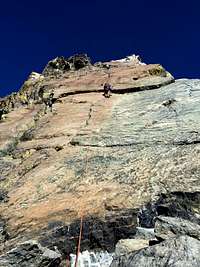
Serpentine Rock | ![Ingalls Peak South Ridge Climb]() South Ridge
South Ridge | ![Start of Ingalls Peak South Ridge]() First Pitch
First Pitch |
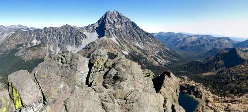
Ingalls Peak is really a series of three peaks: the South North, and East peaks. The North Peak is the central and highest of the three peaks and the one with the two popular climbing routes. From the Lake there was no clear path to South Ridge so we just headed up the slabs of rock and kept aiming for the Dogstooth Spires at the saddle between Ingalls' South and North peaks.
The geology of Ingalls was very interesting. Big veins of white granite split the vast slabs of yellow/brown rock we hiked up. Closer to the climb we encountered a lot of the glassy sea green rock with a texture like scales which I later learned is called "serpentine"—an evocative name that I thought sounded like the name of a legendry jewel that Conan the Barbarian would go on a quest to recover (can you tell I have been reading a lot of fantasy novels this year). We would run into more serpentine on the climb. It would prove to be one of the challenges of the route as it was difficult to find secure footing on the slippery rock.
![Second Pitch Ingalls Peak South Ridge]() Second Pitch
Second Pitch | ![Second Pitch Ingalls Peak s South Ridge]() Second Pitch
Second Pitch | ![Ingalls Peak North Peak Summit]() Scramble to Summit
Scramble to Summit | ![On the summit of Ingalls Peak North Peak]() Summit
Summit |
Arriving at the base of the climb ended up being a case of hurry-up-and-wait. Six climbers were already on the route and two more were waiting for their chance to start. I can't say I wasn't warned. Both of the guidebooks I read advised getting to the climb early because of the popularity of the route. Leaving Seattle when we did, Jason and I thought we were making an early start and hoped to be the first on the route, but all the people ahead of us had camped out the night before. As it turned out we were lucky to get there when we did, we only had to wait half an hour to climb. The climbers ahead of us had been waiting an hour and a half. At least it had warmed up and we were in the sun and chatting with the other climbers while waiting for our turn to climb.
There are two main routes up Ingalls, the South Ridge and the East Ridge. I was hoping for an Ingalls Peak twofer, that we could knock out the South Ridge quick and then squeeze in the East Ridge too, but that was not to be. It was only three easy pitches to the top of the climb and then a short scramble to the summit, but that took over two hours because we would climb a pitch and have to stand around and wait for the multiple climbing teams ahead of us. At the summit we met two more rope teams of three each who arrived via the East Ridge and were planning on rappelling down the South Ridge.
![View of Mt Stuart from Ingalls Peak]() Mount Stuart from summit of North Peak
Mount Stuart from summit of North Peak
At the start of the rappel there was a big vertical face of dark green serpentine that made for a challenging start to the rappel. It was hard to get traction on rock that was so smooth it looked like it had been through a rock polisher. It would take another hour-and-a-half to rappel back down due to all the standing around waiting for the others ahead of us. On the way down there was even another team of four going up. By the time we finished the rappel it had taken three-and-a-half hours and it was too late to start the East Ridge.
Not an epic day of climbing, but it was a great hike. I would recommend the South Ridge as a good place to introduce a friend to multi-pitch alpine climbing. With an early enough start climbing both the South Ridge and East Ridge is feasabile. You could make a fun weekend of it by camping in the Ingalls area and one of the days climbing Stuart via the Cascadian Couloir, a non-technical scramble route accessible from the Ingalls side. If possible I would save Ingalls for a weekday, that way you could (hopefully) avoid the crowds. My only other recommendation is to bring a seventy-meter rope. My sixty-meter rope was just a little short for first pitch and second rappel. You can make it work with a sixty-meter rope, but it will be a lot easier with an extra ten meters.
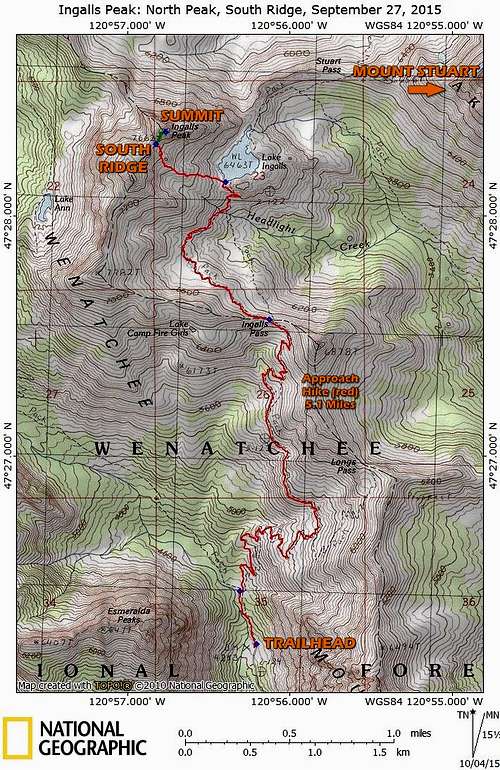
Timeline & Map
| Sunday, September 27, 2015 |
| |
| 5:15 a.m. | — | Leave Seattle |
| 8:00 a.m. | — | Trailhead [4130 ft.] |
| 9:20 a.m. | — | Ingalls Pass [6460 ft.] |
| 11:30 a.m. | — | South Ridge [7312 ft.] |
| Noon | — | Start Climb |
| 2:10 p.m. | — | Summit [7662 ft.] |
| 3:30 p.m. | — | Off Rappel |
| 6:30 p.m. | — | Trailhead |
| 9:15 p.m. | — | Return Seattle |
| |
![Ingalls Peak Approach Hike]() Ingalls Peak: North Peak, South Ridge Approach hike
Ingalls Peak: North Peak, South Ridge Approach hike References
Nelson, Jim; Potterfield, Peter.
Selected Climbs in the Cascades, Volume I. 2nd ed. Seattle: The Mountaineers Books, 2003. Pgs. 76-79.
Smoot, Jeff.
Climbing Washington's Mountains. Guilford, Connecticut: The Globe Pequot Press, 2002. Pgs. 185-189.
Route description includes good sketch of South Ridge route.
Green Trails Maps.
Mount Stuart, WA, Map No. 209. 1:69,500. Seattle, WA:
www.greentrailsmaps.com, 1997. Original Issue 1976.
U.S. Geological Survey.
Mount Stuart, WA. 1:24,000. Denver, CO. Original Ed. 1957, Revised 2003.
As their names imply, both maps are good for Mount Stuart climbing trips too. The Green Trails map is better for hiking details, it names and clearly identifies all the trails, but the USGS map is better for climbing because it has a larger scale and provides more terrain detail.
Samet, Matt; Tea, Mike (ill.).
Climbing Dictionary: Mountaineering Slang, Terms, Neologisms, & Lingo: An Illustrated Reference to More Than 650 Words. Seattle: The Mountaineers Books, 2011.
Dunsany, Lord; Carter, Lin (intro.).
The King of Elfland's Daughter. New York: Ballantine Books, 1969. Originally published 1924.


Comments
Post a Comment