
-
 4020 Hits
-
 83.1% Score
-
 16 Votes
|
|
Mountain/Rock |
|---|---|
|
|
50.02100°N / 126.237°W |
|
|
Hiking, Mountaineering |
|
|
Spring, Summer, Fall |
|
|
5600 ft / 1707 m |
|
|
Overview
 Alston Fin Alston Fin |
Generally regarded as a satellite of Mt Alston, the Fin offers a short scramble from the intervening col and excellent views of its higher neighbour to the east as well as west across the Nimpkish Valley to the Haite and Tlupana Ranges.
An ascent of the Fin can be easily accomplished at the same time as the main peak or it can be treated as a destination in its own right as part of a shorter day.
Of necessity, almost all details applying to Alston Fin can be applied to Mt Alston. They will, however, be repeated here for the sake of convenience and clarity.
Not generally as steep or challenging as their neighbour to the north, Sutton Peak, Alston and Alston Fin have the advantage of a much shorter, more direct approach. In addition, anyone would be hard pressed to find a lovelier place than the alpine meadows in the cirque below the west buttress of Alston and the Fin.
Industrial roads reach out of the Nimpkish Valley to an altitude of over 1,100 metres right on Alston’s SW ridge. From the top of the highest drivable road there remains no more than 200-300 metres of travel through residual logging slash to reach the old growth on the SW ridge and less than an hours travel from there on the well-defined ridge to the Alston/Fin cirque from where the summit of the Fin may be reached after a brief Class 3 scramble.
Mt Alston is named for Edward Graham Alston. Alston was a member of the Legislative Council of Vancouver Island from 1861 to 1862 and was a member of the little heralded 1868 expedition which crossed Vancouver Island from Nootka Sound to the east coast.
Although Alston distinguished himself in public service on the Island, he found himself in opposition to confederation with Canada and in August 1871, shortly after British Columbia entered confederation he left the fledgling province and took up the position of Queen's Advocate in the colony of Sierra Leone, West Africa. There he served as a member of the Legislative and Executive Councils and for several months was acting governor. His career and a promising life were brought to a premature end when Alston contracted and died from "African fever” in Freetown, Sierra Leone on 12 November 1872. He was just forty-one years of age.
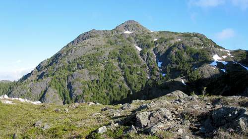
The Fin from the Alston/Fin col
Getting There
Vancouver Island can be reached directly by air from Toronto, Vancouver, Seattle, Calgary, Edmonton and recently from San Francisco to either Victoria, Nanaimo, Comox or Campbell River and by ferry from Port Angeles to Victoria on The Coho and on BC Ferries from Vancouver to Victoria or Nanaimo. Public transport on the Island is notoriously poor and anyone arriving by air would be advised to rent a car.As recently as summer 2009, the approach to Mt Alston and the Fin required you to negotiate steep, narrow, decommissioned industrial roads. For some reason the logging company has filled in the water bars that used to make for a difficult drive. Currently (2012) a normal 2WD sedan without anything special in the way of clearance might be able to reach the top of the highest road providing you don’t mind beating it up a little. Note, however, that although well equipped with switch-backs, the road is very steep at times, often very narrow and exposed to big, unprotected drops on the downhill side. Some may prefer to start off the hike from a lower road and, for this reason, I include that option in the description below.
There are no restrictions, such as gates, on the approach roads but it would be a good idea to check with Western Forest Products Ltd for the latest conditions.
Mt Alston and the Fin can be reached off the Nimpkish Valley Road which itself can be accessed from Gold River to the south and from the inland Island Highway 19 to the north.
For the Gold River approach make your way to Campbell River at the end of the freeway section of the inland Island Highway 19. Take highway 28 west towards Gold River. After 40km you will enter Strathcona Park at Elk Portal. Exactly 1 km further on highway 28 makes a right turn over the bridge at Buttle Narrows. Take this turn and drive all the way to Gold River. There is no gas beyond Gold River so make sure you have enough to cover at least 150 km. From Gold River follow signs initially to Tahsis and Woss. Roughly 2-3 km from town cross the Gold River and immediately take the right fork to Woss (the left goes to Tahsis). This is the Nimpkish Valley Road and pavement soon ends after this point. Drive 27 km from the Gold River bridge - following signs for Woss if in doubt - and find Alston Road on the right.
For the north approach continue through Campbell River on Highway 19 following signs for Port Hardy. Pass through Sayward Junction and 11 km before the turn-off for Woss, turn left at the sign for Schoen Lake Provincial Park. All roads from this point are gravel. Almost immediately after turning onto gravel the road forks. Take the right branch signed for Gold River. This is the north part of the Nimpkish Valley Road. Drive 36 km from Highway 19 – following signs for Gold River if in doubt - and find Alston Road on the left.
Follow Alston Road (called “Lonesome Road” on some older maps) for 1.7 km to a prominent junction and keep right. Drive a further 850 metres and around a long, steep right hand curve to the next junction at N49 59.431 W126 15.803. Keep straight on here. The road now switchbacks its way up the hillside but in a generally northeasterly direction and reaches the next junction at N50 00.004 W126 14.772 after a further 3.7 km. By this point the road is becoming narrow and steep with limited possibilities to turn round. If you’re feeling a bit concerned about road conditions, you have the option to turn right here and drive 1 km to N50 00.285 W126 14.044 from where an excellent elk trail takes you up through the logging slash above and joins the upper road at its terminus. Otherwise keep left and continue up as the road weaves its way back and forth across the ridge in order to gain height. Keep left at a final junction at N50 00.246 W126 14.596 before finally reaching the end of the road at N50 00.357 W126 14.318 8.2 km from Nimpkish Road and at an elevation of 1186 metres. A deep ditch indicated by a felled log indicates the end of the road.
A Garmin MapSource tracklog is available showing all of the roads we explored. Just email me or send me a PM.
The old growth is no more than 10 minutes walk above you to the north.
Approach & Route
From the end of the highest road, cross the ditch and walk a further 100-150 metres up the road. From any convenient point that takes your fancy, make a beeline through the remaining slash at the top of the cut block to the old growth above.Proceed steeply at first up the well defined SW ridge following a reasonable boot path. We concluded that the origin of this path is probably elk hunters. We have seen large numbers of Roosevelt elk on both Alston and on neighbouring Sutton Peak. Unburied garbage and toilet paper below the Fin/Alston col served to reinforce this conclusion. Elk hunting on Vancouver Island is strictly controlled. Anyone visiting Alston and able to collect any evidence of illegal hunting is urged to report all details to the RCMP.
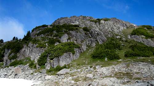
 Fin Climbing route I Fin Climbing route I |  Fin Climbing route II Fin Climbing route II |  Fin summit ridge Fin summit ridge |  Downclimbing the summit block Downclimbing the summit block |
From the last (most northerly) tarn in the meadows in the neighbourhood of N50 00.860 W126 13.941, take a direct line up the crest of the Alston/Fin col above.
Exit the col on its west side and climb steep grass and talus slopes to a flat shoulder on the ridge. Cross the flat area to the base of the imposing summit block and make an enjoyable scramble to the pleasingly airy summit. Hero shots on top are confined to just one person. There is currently neither a cairn nor a summit register.
Retrace your steps to your vehicle or from the col climb Mt Alston as described in that mountain’s SP page.
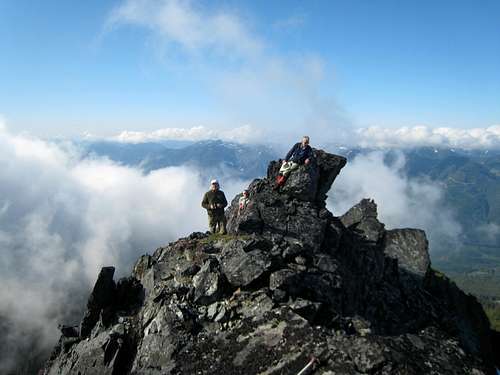
Alston Fin summit
A MapSource/Garmin tracklog is available for the asking for the approach and summit routes. Just send me an email or PM.
Approximate route data for the Fin only.
Total distance: ~ 5 km
Net elevation: ~ 500 metres
Total elevation: ~ 600 metres
Ascent Time: ~ 2-2.5 hours
Descent Time: ~ 1.5-2 hours
Camping
Alston and the Fin can be easily accomplished as a day trip. You might want to get an early start and a car camp may be called for. If so, I’d establish it right at the end of the approach road. It’s inactive and there’s unlikely to be anyone coming this way. There are also great views to the west from this side of the mountain. However there is no access to water, so haul a barrel in with you.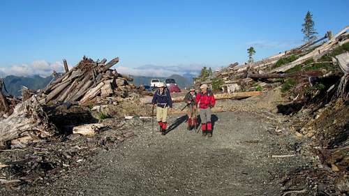
Alston Fin camp and route start
The meadows below Alston are less than an hour from the car and would be an idyllic spot to camp if you enjoy camping for its own sake. If you do decide to camp there PLEASE be careful. Practice your very best no-trace methods, boil or otherwise treat your water and definitely light no fires.
Bear and cougar frequent the mountains and forests of Vancouver Island. Proper back country methods – hanging food bags out of reach, cleaning up all cooking scraps, good toilet practice etc – are all absolutely essential.
Red Tape and Safety Considerations
Absolutely no red tape.There’s nothing resembling a formal trailhead and an intentions system simply doesn’t exist in this neck of the woods. Make sure, therefore, that you have left a detailed trip plan with someone responsible. The RCMP and the appropriate SAR agency will respond in an emergency but it is up to you to have the mechanism in place that will initiate the call-out process if it becomes necessary.
There is no cellular service anywhere on Mt Alston. If this is a concern, equip your group with a satellite phone.
Useful links
For more information refer to Island Alpine – A Guide to The Mountains of Strathcona Park and Vancouver Island, Philip Stone, Wild Isle Publications, 2003, ISBN 0-9680766-5-3For general backroad information and directions get hold of a copy of Backroad Mapbook. Volume III: Vancouver Island
Weather
Nearest point current conditions and forecast.West
East