
-
 16663 Hits
-
 89.77% Score
-
 30 Votes
|
|
Mountain/Rock |
|---|---|
|
|
50.04109°N / 126.23525°W |
|
|
Mountaineering |
|
|
Spring, Summer, Fall |
|
|
6109 ft / 1862 m |
|
|
Overview
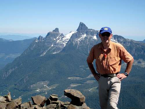
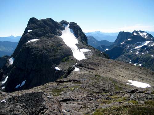 Sutton Peak from ~1.5 km to the NW Sutton Peak from ~1.5 km to the NW |
The signature summit of the range is not the highest – that distinction belongs to Victoria Peak. Instead the status of Sutton Peak probably owes its distinction more to its central location than its altitude. Situated above the Gold/White Rivers and the pass between them to the east and the Nimpkish Valley to the west, Sutton offers astonishing views in all directions. The views will be your just reward for a long and somewhat arduous approach. Although industrial roads reach out of the Nimpkish Valley to an altitude of over 1,100 metres on Sutton’s SW flanks, they don’t get too close to the Class 3 summit block. This lies some 7 km away over two intervening ridges. Although your vehicle is parked with only ~750 metres of relief to cover to reach the summit, you’ll climb almost 1,700 metres and hike about 16 km of map distance to get there and back.
Sutton Peak summit block
Getting There
Vancouver Island can be reached directly by air from Toronto, Vancouver, Seattle, Calgary, Edmonton and recently from San Francisco to either Victoria, Nanaimo, Comox or Campbell River and by ferry from Port Angeles to Victoria on The Coho and on BC Ferries from Vancouver to Victoria or Nanaimo. Public transport on the Island is notoriously poor and anyone arriving by air would be advised to rent a car.The approach to Sutton Peak requires you to negotiate steep, narrow industrial roads that currently (August 2009) are being used to log the surrounding mountainsides. A high clearance vehicle with 4WD should be considered mandatory. There are no restrictions, such as gates, on the approach roads but I would, nevertheless, restrict access to weekends until active logging ceases. Or better still call Western Forest Products Ltd for the latest conditions before venturing into the area.
The most efficient route into Sutton Peak is from the inland Island Highway 19 to the north.
Drive through Campbell River following signs for Port Hardy. Pass through Sayward Junction and 11 km before the turn-off for Woss, turn left at the sign for Schoen Lake Provincial Park. All roads from this point are gravel.
Almost immediately after turning onto gravel the road forks. Take the right branch signed for Gold River. This is a public road but keep your lights on and watch for logging trucks nevertheless. Drive 18 km from Highway 19 to arrive at an open log-sorting yard complete with logging railway siding. Go to the NE corner of the yard and locate Stuart Road. There is also a sign for Fiona Road. Drive Stuart road for 6.5 km to the point where Fiona branches right. Take Fiona. Drive Fiona for 2 km to an unsigned spur on the right. NOTE 200 metres before the correct spur a brand new road goes off to the right. This may tie in with the roads described below but we didn’t explore it and, therefore, report only what we know works.
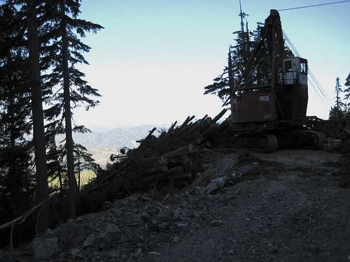 Grapple yarder high on the Sutton approach |
Go straight ahead at the T-junction and drive as high as you can following the main line as it switchbacks up the hillside. If in doubt go right when faced with a choice. The end of the highest spur that you’re aiming for is at N50 02.323 W126 17.745 and 1158 metres altitude. A MapSource/Garmin tracklog of the road approach is available to anyone needing it. Just send me an email or PM.
It is highly likely that there will be logging equipment parked on the road. If you intend to return only after the advent of working hours, park your truck well out of the way. There is an excellent small side spur that doesn’t appear to be being used at the moment at N50 02.451 W126 18.176 that does admirably for this purpose. It is, however, a 10 minute walk up the road from here to where the approach route starts.
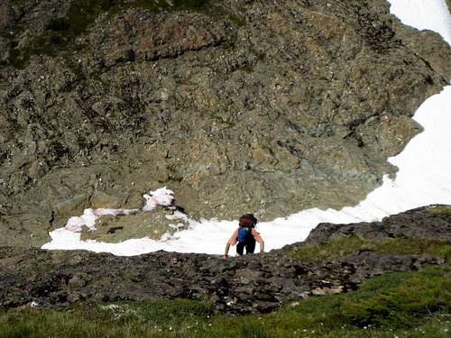
Approach
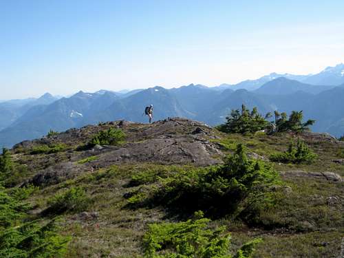
Leave the road that you’ve driven up right at the very end. There is no flagging or cairn marking the spot. Head NE into the bush to N50 02.349 W126 17.686 where there is a flag. Go down and across a stream which may be dry, up the far bank and pick up an elk highway continuing NE. Follow the elk trail when you can and the occasional flag when you can’t - just keep heading northeast. After 30 minutes you’re into the alpine and 15-20 minutes after that you will intersect the line of the first ridge system that leads to Sutton. Look to do this in the neighbourhood of N50 02.696 W126 17.374Once on this first ridge, turn right and make your best route along it east and then northeast crossing several high points along the way. You’re soon on open ground with views in all directions except towards Sutton which is hidden by a second ridge across the valley to the east.
 First Approach Ridge | 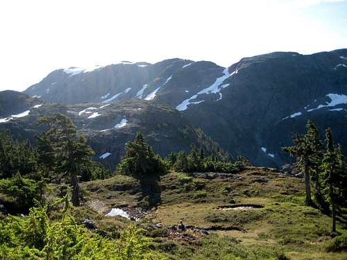 Second Approach Ridge | 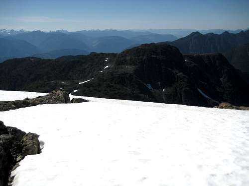 Second Ridge | 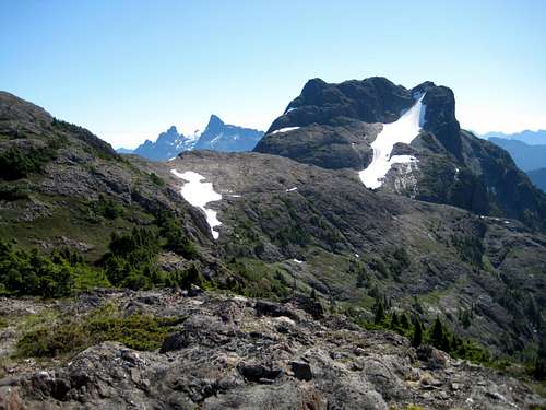 Sutton from the Second Ridge |
Continue SE out of the col and up to the crest of the second ridge 250 metres above. The summit block of Sutton now comes into view for the first time to your east. Turn left (NE) and hike up towards the high point of the ridge. Snow fields on the north side make for easy travel during this phase. Once on the high point the impressive summits to the east of the White/Gold Pass – Victoria and Warden Peaks – come into view.
Once again look to avoid going right over the highest point on the ridge and, as soon feasible, make a descending traverse another ~150 metres SE into the col at the base of the summit block.
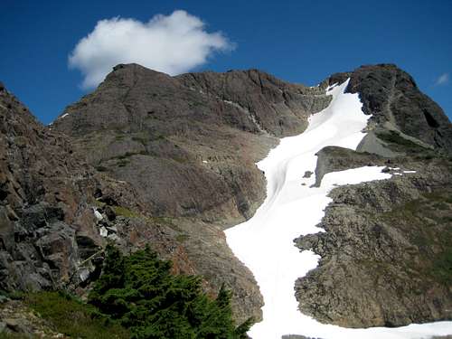
Summit Route
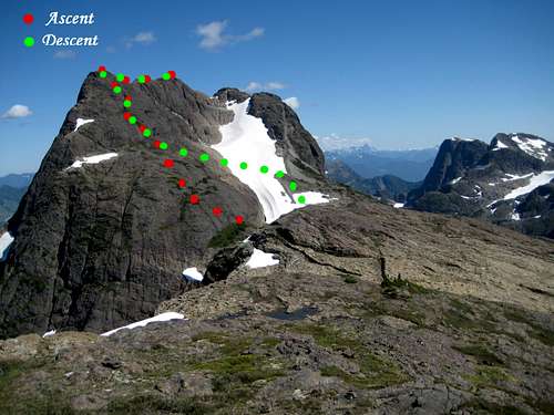 Summit Route overview I Summit Route overview I | 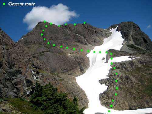 Summit Route overview II Summit Route overview II |
The west face of the summit block is split by a large snow field in the south and guarded by a cliff band at the foot of its northern half. We chose an ascent line that took advantage of a weakness in the cliff band and subsequently descended from approximately the mid point of the snow field as illustrated in the attached photographs and described as follows.
From the col climb grassy slopes up to the cliffs and look for a narrow ramp heading up from right to left. Climb this at easy Class 4 to an open area above the cliffs where the angle eases. From the open area scramble easy ground, staying left to avoid difficulties, before traversing back right and climbing a series of steep Class 3 heather filled chutes that lead directly to the northwest summit. From there walk across to the main SE summit in 5 minutes or less.
 Climbing Through the Cliff Band | 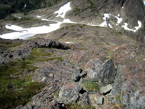 Upper West Face | 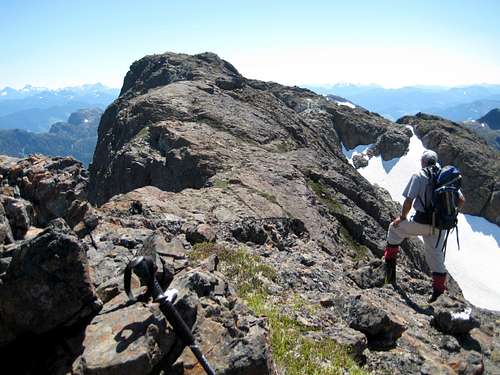 Sutton Main Summit from NW Summit |
In spite of reports to the contrary we found no summit registers in the form of film canisters on either summit. Sutton is rarely visited, so we made some needed repairs to the summit cairns.
 Sutton Peak Summit | 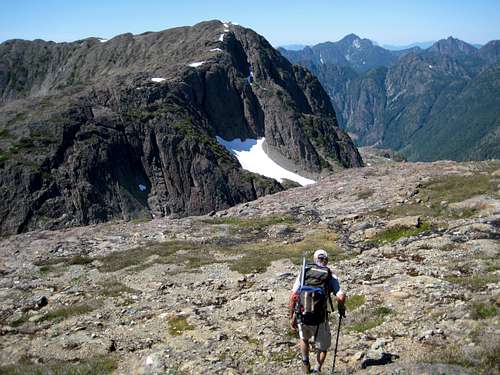 Descending Sutton | 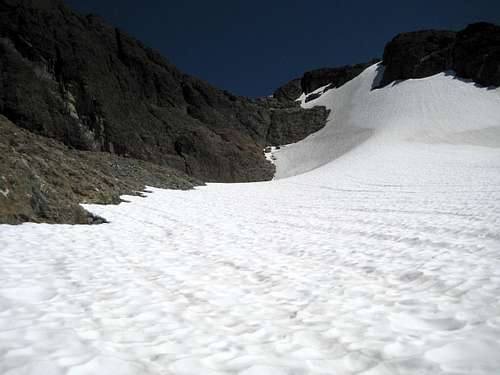 Crossing the Summit Block Snowfield |
Our views from mountain tops are usually all about looking across or up to neighbouring peaks. In Sutton’s case don’t omit to look down and northeast. In the cirque 600 metres below are two of the most breathtakingly lovely alpine tarns that I have ever seen or am ever likely to see.
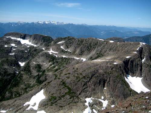 Summit view NW Summit view NW | 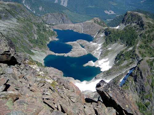 Alpine tarns below Sutton Alpine tarns below Sutton |
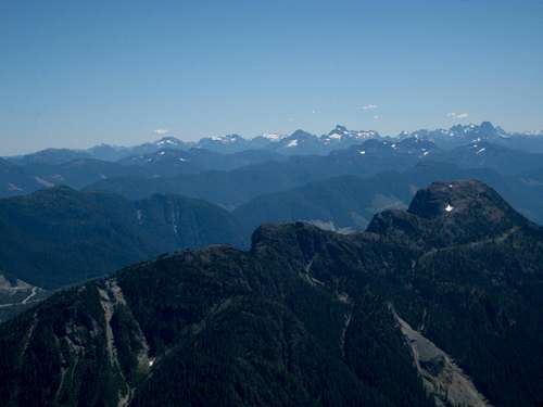 Summit view S Summit view S | 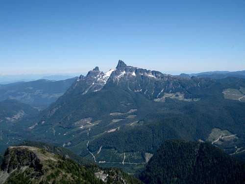 Summit view E Summit view E |
Return to your vehicle by returning from the col along the ridges described above.

Sutton Peak route profile
A MapSource/Garmin tracklog is available for the asking for the approach and summit routes. Just send me an email or PM.
Approximate route data.
Total distance: ~ 16 km
Net elevation: ~ 750 metres
Total elevation: ~1,700 metres
Ascent Time: ~ 5-6 hours
Descent Time: ~ 4-5 hours
Red Tape and Safety Considerations
Absolutely no red tape.There’s nothing resembling a formal trailhead and an intentions system simply doesn’t exist in this neck of the woods. Make sure, therefore, that you have left a detailed trip plan with someone responsible. The RCMP and the appropriate SAR agency will respond in an emergency but it is up to you to have the mechanism in place that will initiate the call-out process if it becomes necessary.
There is no cellular service anywhere on Sutton Peak. If this is a concern, equip your group with a satellite phone.
Camping
Most will tackle Sutton as an (albeit long) day trip. Nevertheless, you’ll likely want to get an early start and a car camp may be called for. If so, I’d establish this right at the end of the road if the approach is clear of logging equipment or on the parking spur described above if not. There are great views to the west from the second spot. Neither has access to water, so haul a barrel in with you.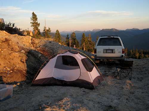 Car Camp Below Sutton |
Bear and cougar frequent the mountains and forests of Vancouver Island. Proper back country methods – hanging food bags out of reach, cleaning up all cooking scraps, good toilet practice etc – are all absolutely essential.
Useful Links
For more information refer to Island Alpine – A Guide to The Mountains of Strathcona Park and Vancouver Island, Philip Stone, Wild Isle Publications, 2003, ISBN 0-9680766-5-3For general backroad information and directions get hold of a copy of Backroad Mapbook. Volume III: Vancouver Island
Weather
Nearest point current conditions and forecast.West
East
Summit Panorama
No Vancouver Island Mountain page would be complete without a composite panorama from the summit of the featured mountain. Enjoy this one from the main summit of Sutton Peak from the southwest to the northwest  |