
|
|
Route |
|---|---|
|
|
41.14110°N / 74.8589°W |
|
|
Hiking |
|
|
Spring, Summer, Fall, Winter |
|
|
Most of a day |
|
|
Class I |
|
|
Approach
From Interstate 80From East or West exit at Exit 19.
Turn on to County Road 517
Stay on 517 until it reaches U.S. 206
Take 206 North until you reach Culver Lake.
About a half mile after Culver Lake turn right on to County Road 636. Follow signs for Parking lot. You must register your car at the Stokes State Forest Office for overnight parking, It is free.
The office is furthur along 206 north. About a mile. you must register or your car WILL be towed.
 |  |  |  |
Route Description
Start at the parking lot, mile 0.0. At the far end of the parking lot there is a sign for the Appalachian Trail turn left on the A.T.At mile 0.2 cross U.S. 206 and head into the woods.
At 0.7 miles you will cross under powerlines and the gold and brown blazed Acropolis Trail.
At 1.0 miles you will reach the crest of the ridge, the trail will make a right angle turn to the left.
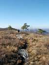
At 1.4 miles you will reach a view point with views of the Culvers Lake area.
At 2.1 miles you will cross the gray and blue blazed Jacobs Ladder Trail.
At 2.3 miles there will be a viwe point of Lake Owassa on the left.
At 3.4 miles there should be a trail register, please sign it if it is there.
At 3.8 miles you will reach Brink Road follow it west to Brink Road Shelter.
At 4.5 miles you will reach the summit of Blue Mt. with views of the Wallpack Valley and the Pocono Plateau.
At 4.9 miles you will reach the boundary of Stokes State Forrest and the Delaware Water Gap National Recreational Area. Turn left on to a dirt road.
At 5.2 miles you will reach the summit of Bird Mt., the highest of the three, with limited views at the summit. There are side trails to view points.
At 5.7 miles you will reach the col between Bird Mt. and Rattlesnake Mt.
At 6.1 miles you will reach the summit of Rattlesnake Mt. It offers nice views. Return the same way. The trail is not well blazed in some areas (summit of Blue Mt. and near the Acropolis Trail as examples) if you find your self off-trail just backtrack to avoid creating heard paths all over the place.
 |  |  |  |  |