
|
|
Canyon |
|---|---|
|
|
50.91905°N / 15.70702°E |
|
|
Hiking, Canyoneering |
|
|
Spring, Summer, Fall |
|
|
Overview
 Near Stanek
 Borowy Jar
 Near Barcinek
Bóbr is the same word than Bober in some Anglo-Saxon dialects, Biber in German and Beaver in English. It is easy to figure out the etymology of this river's name.
Before any geographic data: Why a canyon ? On most of its length (268km, from its source running shortly in Czech Republic, to its junction in the Oder), the Bóbr is only a "normal" river.
But, the number of places where its bed goes into remarkable geologic features, including a genuine canyon (Borowy Jar) near Jelenia Góra makes a first good argument.
And above all, the Bóbr is the local Mecca of water sports, especially kayaking, and even canyoning in a couple of spots.
The Bóbr flows into three emblematic regions of the range of the Sudetes :
- Karkonosze (Giant Mountains), or more exactly the Lasocki ridge (Lasocki Grzbiet), east from Śnieżka
- Rudawy Janowickie, in particular the beautiful loop it describes around the Sokoliki hills
- Góry Kaczawskie (Kaczawa Hills), volcanic piedmont of the range, where the river slowly leaves its mountainous character and reaches a quieter stage.
 Jezioro Pilchowickie reservoir
Karkonosze section
 Karkonosze
 From Cieplice
 Snow melting
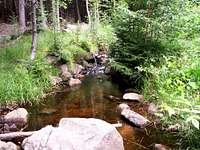 The Janowka, tributary
The Bóbr takes its source at "Boberská stráň" (Boberlehne in German), around 800m of height, near the town of Žacléř, in the Rýchory (Czech counterpart of the Polish Lasocki Grzbiet).
It enters very soon Polish territory, and capter for the first time into a large reservoir, Jezioro Bukówka. Then the small Bóbr crosses the town of Lubawka, Kamienna Góra, under which it fusions with the river Lesk that doubles suddenly its width.
From this point, we can say the Bóbr leaves the Karkonosze territory to enter Rudawy Janowickie. It has already gone down 400m, more than the half till its junction with the Oder...
Rudawy Janowickie section
 Near Wojanów
 Near Wojanów
 From Sokoliki rocks
 Friendly locals
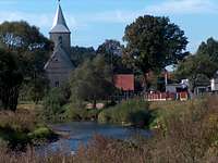
From Kamienna Góra, the still young but yet significant Bóbr enters a stage of countless meanders in which it still flows rapidly like any true mountain river.
It crosses the villages of Marciszów, Ciechanowice, and then the town of Janowice Wielkie, "capital" of Rudawy Janowickie.
Later, near Trzcińsko where the large curve it describes around the Sokoliki hills is one of its most photogenic places, including as seen as the top of the Sokoliki rock.
On its bank are now located many manors and castles worth mention, like the photogenic Wojanów. Note that the portion of road between Trzcińsko and Wojanów is a very scenical place to drive (but narrow !), or bike.
The Karpniki artificial fishing lakes, alimented by Karpniki Potok, join the concert to enlarge the river a bit again, before passing Łomnica Dolna.
Another river worth mention despite less important is the Janowka, abundantly depicted by member Romuald Kosina in his album.
Then Bóbr enters slowly and anonymly the subburb of the large town of Jelenia Góra, with its magnificent old medieval centre.
 The Bóbr river in Rudawy Janowickie
Borowy Jar & Pilchowice
 Near Jelenia Góra
 Canyon Borowy Jar
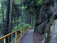 Canyon Borowy Jar
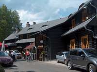 "Perła Zachodu"
 Near Siedlęcin
 Near Barcinek
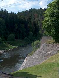
Downstream from Jelenia Góra begins the most interesting section of the river Bóbr: the canyon Borowy Jar.
Don't expect to find any wild place: the canyon is tamed since long ago, during the period when the region was a part of Germany a lot of electrical dams were erected in order to create artificial reservoirs that feed power plants. However these installations are far to be ugly: more than hundred years old for many of them, they are interesting to watch and somehow now part of the landscape.
Jezioro Modre and the Bobrowice dam are the first of them. This spectacular place (very steep and deep) is overlooked by the only mountain hut of the region located in such place: Schronisko PTTK - Perła Zachodu. The first part of the canyon is featured with a flat asphalted bicycle track that will delight all casual bikers. The rest is tougher (MBPost trail being currently built)
It ends in the village of Siedlęcin where the trail goes now on the right bank, on a narrow pedestrian track. Many fishing spots there are appreciated by the focal fishers. The pines that border the emerald water of the suddenly quieter Bóbr make this section very pleasant. It ends as the Bóbr gets larger again, at the next dam near Stanek.
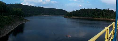
Below this point, an even larger reservoir is located, the largest on all the mountainous bed of the Bóbr : Jezioro Pilchowickie. Due to the sharp configuration of the terrain there is no trail following directly the shore, but many go a bit aside. The promontory on the left bank of its lower side is the most common hiking goal, as well as the walk over the dam that leads to the right shore, on which a friendly inn is located.
Another scenical way to reach this place is by train: the station of Pilchowice itself is a must-see viewpoint over the lake.
 Jezioro Modre reservoir
Góry Kaczawskie section
 Near Pilchowice
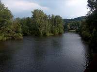 Near Pilchowice
 Near Pilchowice
 Near Pilchowice
This section of the river that makes the last portion in mountainous zone is the one that interest the most amators of water sports: kayakers of course, but also canoe, hydrospeed, and so on. These sports are also practiced on the Kwisa that merges with the Bóbr near Lwówek Śląski.
This relatively quiet part of the Bóbr starts from the village of Pilchowice, and goes through Nielestno, Wleń and goes approximately until Lwówek Śląski, the next large town which can be considered as the end of the mountainous zone.
The elevation lost is not as important as the previous sections, but many smalls lockers and dams are encountered from time to time.
Cyclotouring at a modest level is also usually done from this level, from now constantly on asphalted tracks, via the ER6, the official European bike trail of the Bóbr valley (upstream, trails are more demanding).
 Jezioro Pilchowickie dam
Lower bed
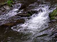 Little cascade
 A southern view...
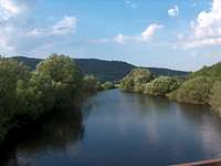
From Lwówek Śląski, the Bóbr becomes a quiet river in the flat noth regions of Lower Silesia, and runs parallel with the Neisse that makes the border with Germany.
The Bóbr crosses the city of Bolesławiec, Leszno Górne, Szprotawa, Żagań, Nowogród Bobrzański until Dychów where it merges with the Oder. This final zone made of marshland and fragile ecosystems , "Dolina Dolnego Bobru" is classified Natura 2000, and will fulfill bird observers.
Getting There
Wroc%C5%82aw is the nearest large city owning an airport.From Wroc%C5%82aw, a one and half hour drive is needed to Jelenia Góra, the usual place to go for visiting the most touristic places. For the lower bed of the river, continuing west on the A4 is more advised.
Jelenia Góra, as well as many other villages on the bank of the river are served by train, including photogenic viewpoints like the Pilchowice station.
View Larger Map
Bicycle lovers might also be intersted about the ER-6 ("Euroregionalny Szlak Rowerowy ER-6"), bike trail running all along the bed of the river :
Accomodation
All the area close to mountains and ski resorts usually have a lot of modern accomodations. For more remote places, the density is lower, but one will find more genuine accomodations locally known as "agrotouristic" (green B&B's).A lot of portals summarize all accomodations on internet, but unfortunately rarely in English or foreign languages. Since an inventary of all of them would be too much work, and the data is changing constantly, here are only a couple of tips to help to sort it out.
A small lexicon:
- Accomodation = Noclegi
- Green lodge = Agroturystyka
- Guesthouse = Pokoje gościnne
- Summer residence = Dom letniskowe
- Flat for rent = Kwatery
- Mountain hut = Schronisko
- Campsite = Kemping
Few links :
- Mountain hut Perła Zachodu in the canyon Borowy Jar
- Duch Gór, local portal with accomodations listed
- Park Krajobrazowy Doliny Bobru, the official page for the region