Overview
![Pelister peak on Baba mountain as seen from NW]() Pelister peak on Baba mountain as seen from NW
Pelister peak on Baba mountain as seen from NW
The
Baba (eng. Grandma) mountain is situated in the south-western part of the
Macedonia, between the valleys of
Prespa and
Pelagonia. It is mostly known under the name of the
Pelister national park, which is part of the Baba mountain (it takes approximately 20% of the mountain). However, the Baba offers much more (the areas that are not included in the Pelister national park boundaries are poorly visited and known).
The
Baba mountain is probably the most visited mountain in Macedonia by the tourists and the mountain climbers, due to the natural beauties of the mountain, easy ways of reaching, good marked trails, numerous places to stay etc.
The mountain is approximately long
40 km and wide
20 km and takes an area of approximately
600 square kilometres. Around 65% of its territory is situated in the
Macedonia and 35% in
Greece. During the diluvium period the mountain was covered with ice and snow, causing the recent remains of that period: cirrus, moraines, valleys and glacial lakes.
![]()
Peaks
|
The Baba mountain has more than 20 peaks over the 2000 meters above the sea level. The most important ones are:
• Pelister (2601 m)
• Ilinden (2542 m)
• Stiv (2463 m)
• Veternica (2420 m)
• Siroko stapalo(2415 m)
• Muza (2350 m)
• Partizanski vrv(2349 m)
• Rzana (2334 m)
• Bojadziev vrv (2329 m)
• Mrazalnik (2235 m)
• Skambi i rofes(2196 m)
• Golema Cuka (2179 m)
• Tumba (2176 m)
• Golema griva (2166m)
• Bela voda (2156 m)
• Skrkovo (2146 m)
• Cuce (2120 m)
• Vrteska (2010 m)
• Kozji Kamen (2108 m)
• Gura (2103 m)
• Baba (2093 m)
• Mala Cuka (2009 m)
• Izvidnica (1986 m)
• Crn Kamen (1909 m)
• Neolica (1863 m)
• Babin zab (1850 m)
• Jorgov kamen (1744 m)
|
![Stiv peak seen from the Lastojcin kamen area near the hotel of Molika]() Stiv peak (2463 m) as seen from the Lastojcin kamen area near the hotel of Molika
Stiv peak (2463 m) as seen from the Lastojcin kamen area near the hotel of Molika
|
Glacial lakes and rivers
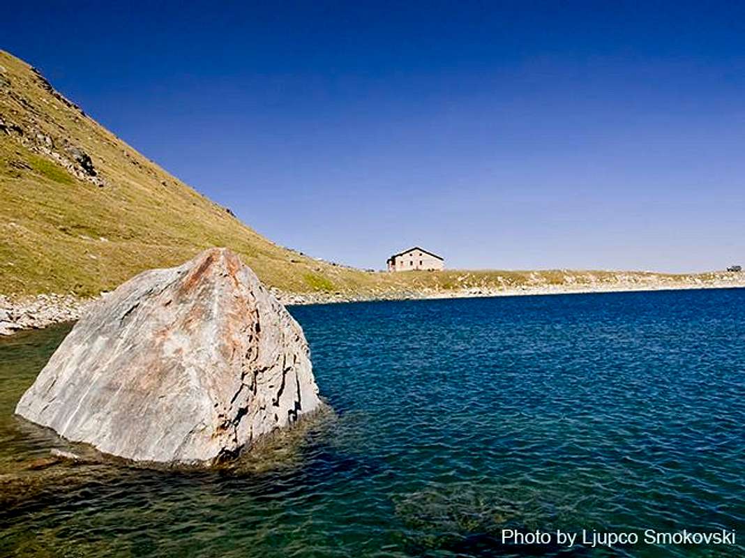
One of the most beautiful mountain features are the two glacial lakes. The
Golemo ezero (Big lake) is situated on the 2218 meters above the sea level. It is long approximately 220 meters and wide 160 meters. Its depth is approximately 15 m. There is a mountain hut situated at the lake shore.
The
Malo ezero (Small lake) is situated on the 2180 meters above the sea level. It is long approximately 80 meters and wide 70 meters.
There is another impermanent lake called
Orlovi Bari, near to the peak of Golema Griva.
The most important rivers on the range are:
Shemnica, Malovishka, Caparska, Rotinska, Crvena, Ezerska, Sapundzica, Zlokukjanska, Ostrecka, Brajcinska, Kranska.
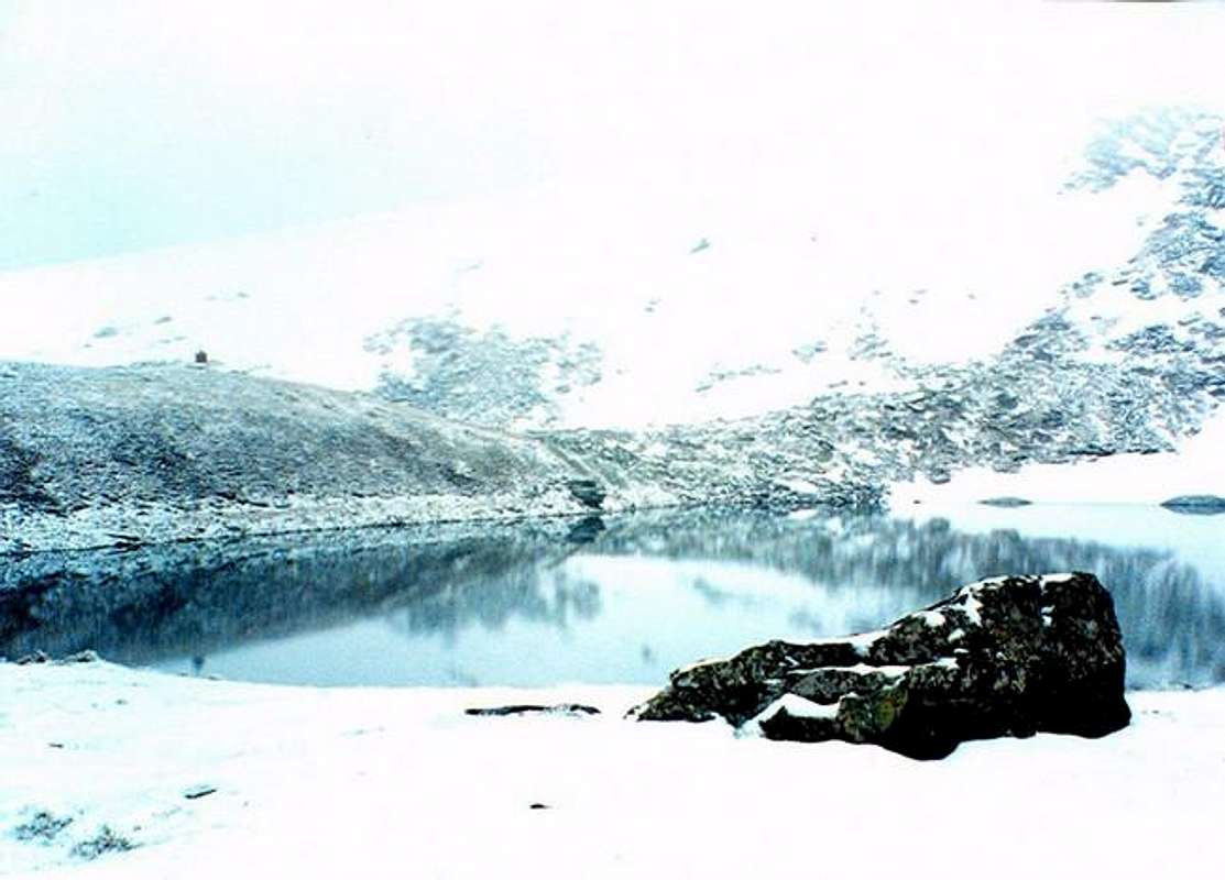
![Golemo ezero (Big lake)]() Golemo ezero (Big lake)-2218 m
Golemo ezero (Big lake)-2218 m
Stone rivers
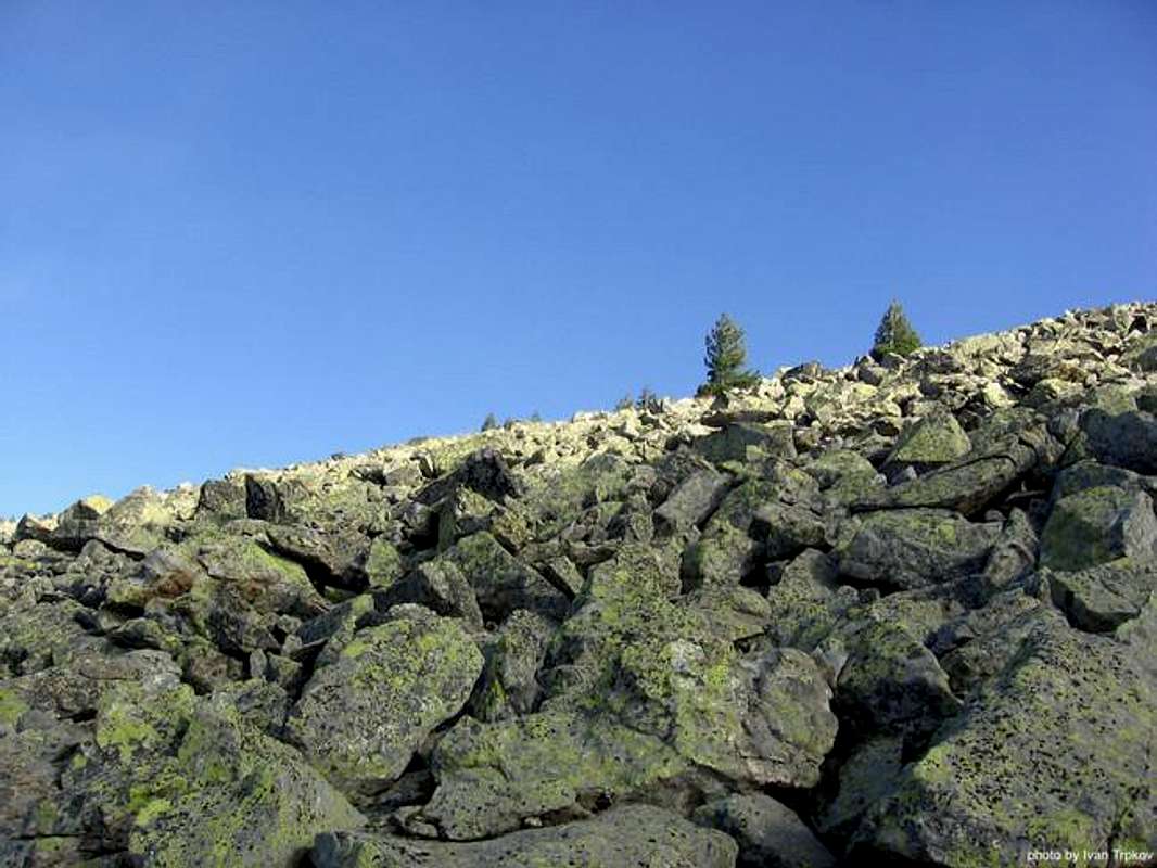
One of the most interesting features on the mountain are the “
stone rivers”. They have been formed on weathering the rocks and their slow moving to the valleys as a result of the flowing water gravitation. They can be found at many places in the Baba mountain.
![Stone river]() Stone river - one of the most interesting features on Baba mountain
Stone river - one of the most interesting features on Baba mountain
Pine forests and wildlife
The
Molika pine, also called “Pelister’s beauty”, is a well-known attraction on Baba. It’s a five-needled pine that grows only on a few parts of the Balkan Peninsula. In sub-alpine region of Baba mountain, a considerable area is covered by this pine (Pinus peuce). In the very favourable growth conditions at the sub-alpine region, the mixed molika-beech co enosis is represented.
On Baba one can also encounter the endemic Pelister snowdrop. The beauty of the landscape is enhanced by the diversified wildlife: bears, roe deer, wolves, chamois, deer, wild boars, rabbits, several species of eagles, partridges, red billed jackdaws, and the endemic Macedonian Pelagonia trout.
![Molika pine forest in winter]() Molika pine forest in winter
Molika pine forest in winter
Mountain borders
In the
north, the mountain is separated from the
Bigla mountain with the
Gjavato pass (1167 m). The border stretches along the Gjavato valley (800 m) and descends close to the town of Bitola.
Then the border goes in the south direction, separating the mountain from the Pelagonia valley even reaching the Macedonian/Greek border line.
After the state border crossing, the mountain border goes in the western direction, reaching the
Pesoder pass (1505 m), separating the Baba mountain from the
Neredska mountain. The border now follows the valley of
Bistrica river, going SW, reaching the
Prevol pass.
The valley of
Mala Prespa is next natural end of the mountain, where the border takes the north direction, near the
lake of Prespa.
After the lakes, the
Resen valley forms the mountain border that finally reaches the Gjavato pass again.
Main ridge
Baba mountain has well formed central ridge and 6 significant separations.
The
main ridge begins SW from the villages of
Trnovo and
Magarevo and ends in the
Prevol pass. It stretches in the NS direction. From the mentioned villages, the first noteworthy peak is
Izvidnica (1986 m), just above the
Kopanki hut. From there, the ridge goes higher, reaching the
Stiv peak (2468 m).
In the western direction the ridge now forms the peak
Ilinden (2542 m) and reaches the mountain highest peak –
Pelister (2601 m).
The ridge continues in the SW direction through the peak of
Siroko Stapalo (2415 m).
From that peak, in the SE direction are situated the peaks
Partizanski (2349 m) and
Veternica (2420 m). Next important peaks are
Golema griva (2166 m) and
Muza (2350 m).
From
Muza peak, the main ridge reaches the peak of
Baba (2093 m) and goes in SW direction to the state border with Greece. Situated on the border line is the peak of
Rzana (2420 m).
The most important peaks on Greek territory are:
Tumba (2176 m) and
Bela Voda (Kalo Nero – 2156 m).
National park Pelister
The
Pelister national park is part of the Baba mountain. There are 37 species of woodlike plants, 31 species of bushes, 18 species of forest communities and 27 grassy communities located within this national park. Among plant communities, the largest surface area is covered by
pine forests covering exclusively a surface area of 1.174 ha, and there are also pine-fir, pin-beech, pin-beech-fir, beech and oak-beech forests. Among flora elements, the presence is especially significant of the five-needle pine molica (Pinus peuce)- a unique species of tertiary age being present on only a few mountains in the Balkan Peninsula. It reaches its development peak on 1000 to beyond 2.200 m.a.s.w. Within high mountain layers, the following endemic plants may be found: Crocus peristericus, Dianthus myrtinervius, Sempervivum octopodes and Alchemilla peristerica.
As for the vertebrate fauna, there are 12 amphibian, 16 reptiles, 130 bird species and 37 mammal species, special attention deserved by the bear, the doe, the lynx, the wild goat, the deer, the wild boar, the stone partridge (Alcetoris graeca), the golden eagle (Aquila crhysaetos), the stone creeper (Tichodroma muraria) and the red-beak corax (Pyrrhocorax pyrrhocorax). Among the fish, the presence of the endemic Pelister trout is of special significance (Salmo peristerrious Karaman).
For more info about the Pelister national park, please click on the following link:
Pelister
Kozji kamen area
The area of
Kozji Kamen begins from the
Siroko Stapalo peak through the
Dva Groba pass in the north direction, forming the interesting peak of
Kozji Kamen (2108 m). The peak has very interesting rock shape.
The Kozji kamen ridge is situated between the Caparska and Malovishka rivers.
Main villages in this part of the Baba mountain are:
Capari, Rotino, Malovishte and
Kazhani. In the last years, many work has been done in order to introduce the tourism benefits to the local people and many projects have been implemented or are under way, so the tourist can enjoy the taste of the real village life and environment hosted by the generous local inhabitants.
The village of
Malovista is located in the vicinity of the town of
Bitola. It is a mountain village at the foot of the Pelister Mountain and it is the only settlement within the “Pelister” national park. There are some 300 people living in Malovista, and 300 more people come to the village during weekends. You can reach Malovista from the main road between Bitola and Ohrid. At an 18-kilometre distance from Bitola, on your right side, you will notice a road leading directly to the Malovista village. The village is reachable by car, using an asphalt paved road.
Visitors can stay overnight in a private house in the village; in summer, you can also use the rooms at the
monastery of St. Anna located in a nearby forest. Malovista is a specific village with interesting, authentic architecture. The village has nice, large houses built of stone in a traditional manner. A feature of the old architecture here are the maintained old cobblestone small streets, the stone bridges, and the appearance of a small town settlement.
In the centre of the village is located the
church of St. Petka with its fresco paintings and with its extraordinary wooden iconostasis with deep carving. There is a public building in the village displaying an exhibition of the village's traditional culture items.
Two very important monasteries are situated near the village, the first one,
St. Ana is close to the village, and the second one,
St. Spas is located in about 2 hours walking from the village.
![Scene of a glacial lake Big Lake 2218 m]() Scene of a glacial lake Big Lake 2218 m
Scene of a glacial lake Big Lake 2218 m
Chuka area
Chuka ridge is one of the longest separations from the main ridge. It borders with the
Malovishte valley from the eastern side and the
Prespa valley from the western side. From the
Siroko Stapalo peak it goes in the western direction, forming the peak of
Golema Chuka (2189 m).
From this peak, it goes north, forming the
Mala chuka (2000 m) peak. The ridge now descends, forming the
Kodru pass (1739 m). After the pass, the next important peak is the rocky summit of
Vrteshka (2010 m).
Whole range can be easily seen when a tourist descends from the
Galichica mountain (an asphalt road connects the
Ohrid and
Prespa valleys through the
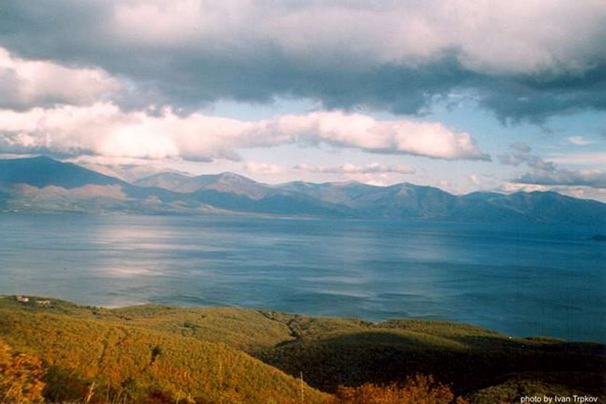
Galichica mountain). A beautiful panorama is opening before the eyes, the Prespa lake blue water reflects the high peaks of the ridge.
Prespa Lake is the second biggest lake of the Dessaret group of the Aegean Lake Zone. It is situated in the deepest part of the Prespa basin. It flows into the
Ohrid Lake (a World Heritage Site), which is 158 m lower, through limestone caves in the
Galichica mountain. The eastern part of the lake is barren and strewn with sand beaches, while on the western side there are cliffs.
In the southern part lies the island
Golem Grad, with steep banks and cliffs. Between the villages of
Sirhan and
Asamati is a wider zone of very shallow banks. Frequent sandbanks extend parallel to the lakeshore. In 1996 the northern part of the lake (2,080 ha) was declared a strictly protected ornithological reserve,
Ezerani. Most important villages form the Prespa valley side are:
Kurbinovo, Asamati, Pretor, Slivnica, Arvati, Krani and
Strbovo.
Near the village of Kurbinovo is a monastery church dedicated to
St.George, built in 1191 and famous for its frescos.By its shape and dimensions, the church is simple. But the well-preserved frescos place this church is the pearls of the medieval art of Macedonia.
Near the village of
Slivnica is situated the famous
monastery of St. Bogorodica (Holy Virgin), built in 1606. The monastery is located a ten to fifteen minutes walk above the village of Slivnica towards Pelister. The church was built and decorated in the 17th century and features well preserved wall paintings from the Macedonian school of painting from this period.
To get to Slivnica, turn off the main road on Prespa Lake between Krani and Pretor.
![Chuka area and other parts of Baba mountain reflecting in the Prespa lake as seen from the Galichica mountain]() Chuka area and other parts of Baba mountain reflecting in the Prespa lake as seen from the Galichica mountain
Chuka area and other parts of Baba mountain reflecting in the Prespa lake as seen from the Galichica mountain
Gura area
The
Gura area begins from the peak of
Veternica in the SW direction. The most important peak on this separation is
Gura or
Marushica(2103 m).
The ridge is separated from the rest of the mountain by the
Kranska and
Brajcinska rivers.
Ljubojno is the village you pass two kilometers before entering
Brajcino. It has a mixture of town and village houses, some of which are evidence of an earlier prosperity.
Stroll around the village and visit the two churches,
St. Peter and
St. Paul, which are a short pleasant walk from the village.
The Mountain Nature Trail is the main natural attraction, leading from the village of
Brajcino to
Big Lake. The trail links the Prespa Lake region with the Pelister National Park and provides breathtaking views and magnificent landscapes. It features seven illustrated information stations at different altitude zones, from 1000 meters above sea level in Brajcino to 2400 meters near Big Lake. Climbing time is approximately 5-7 hours and mountain guides are a must for climbers not familiar with the region. They will also enhance your experience in the mountains with their knowledge of local wildlife, which includes bears, wolves, boars, etc.
The Brajcino Hike runs along the slopes above Brajcino past six churches and with views down the Brajcino valley to Lake Prespa. This hike provides a splendid experience for the hiker who doesn't want to go for the longer trip, but still wants to enjoy nature and to learn about the local livelihood on the mountain. A guide is recommended for hikers not familiar with the region. The hiking time is between 3 to 5 hours.
Neolica area
From the Muza peak in the NE direction goes the fourth significant separation-
Neolica, forming the peaks of
Skrkovo (2140 m),
Crn kamen (1909 m),
Neolica (1863 m),
Babin zab etc. More info about this ridge can be obtained at the following link:
Neolica
![A view from the highest peak Pelister (2601 m)]() A view from the highest peak Pelister (2601 m)
A view from the highest peak Pelister (2601 m)
Rzana/Cuce area
The
Rzana/Cuce area begins at the peak of
Rzana in the western direction and shapes the Macedonian/Greek state border reaching the
Prespa Lake.
The highest peak on the range is
Bojadziev (2329 m), separated from Rzana peak with the Rzana pass. Just above the Prespa Lake is raising the
Cuce peak (2120 m). On the western slope of the ridge, in the Macedonian territory, are placed the villages of Dragosh, Kishava and Graeshnica. From the Greek side, on the southern slopes of the ridge, are placed the villages of Krateron, Germanos etc.
Tumba area
The last, sixth separation of significance is
Tumba and it is completely in the Greek territory. It separates from the main ridge forming the peak of
Tumba (2176 m) in the NE direction and the peak of
Bela Voda (Kalo Nero) (2156 m) in the SW direction.
The ridge ends in the eastern direction just above the sity of
Lerin (Florina) in Greece.
Getting There
The
eastern side of range can be very easily reached from several places. The main entry point is the city of
Bitola, located just near the mountain. Bitola is situated in the south-western Macedonia, near to the border with Greece.
The villages on the edge of the Pelagonia valley are also points for reaching the mountain. The most important villages are:
Lavci, Bukovo, Bistrica, Graesnica etc.
From the
northern side the mountain can be reached from the villages of
Gjavato, Capari, Kazani, Rotino etc.
The
western slopes are reachable through the villages along the shore of the Prespa lake as:
Kurbinovo, Krani, Brajcino, Ljubojno etc.
The
southern side that lies in the Greek territory can be accessed through the city of
Lerin (Florina) and the main villages of the region.
Red Tape
Permits are not required except for the area around the Macedonian/Greek border.
Aditionally, the climbers there can be very easily misleaded regarding the numerous routes that are going in different directions and it is advised to go in that area accompanied by a more experienced climbers that are familiar with the place.
Also, special attention should be paid on the preservation of natural heritage of the Pelister national park. There are sanctions if the visitor tries to cause some kind of damage to the plants and wildlife. Also, the use of cars in some of the unpaved roads through the mountain is banned.
When To Climb
Baba mountain is beautiful in every season, but usually the period from May to September is the best period for enjoying the climbing. Especially, the areas with rock boulders are very hard to be passed during the rain or snow falls. However, the climber should always take good clothing, hiking shoes, food and other stuff.
Accommodation
• The most important tourist centre on the mountain is
Begova Cheshma (15 kilometers from the town of Bitola).
• The
Molika hotel that is situated in the Begova Cheshma area is between the most luxurious in the country. It has around 100 beds in one-bed, two-bed and three-bed rooms.
• In approximately 40 minute distance from Molika hotel (1420 m) is the mountain hut of
Kopanki (1630 m), very well equipped and maintained. It offers around 100 beds.
• Another hotel of importance is the
Detsko odmoralishte hotel (1200 m), used mostly by children during the winter.
• Another important winter sky centre is located on 1150 m above the sea level near to the village of
Nizopole.
• Near the Big lake is the
Golemo ezero mountain hut, also very good maintained. It offers around 50 beds.
• The hut of
Neolica is situated on 1440 meters above the sea level and can be reached very easily from the town of Bitola.
• Also, on the other side of the mountain, the tourists can stay in the villages near the lake of Prespa:
Pretor, Krani, Brajcino, Ljubojno etc.
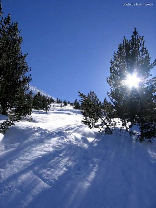
![Winter sun over the Baba mountain]() Winter sun over the Baba mountain
Winter sun over the Baba mountain
 37727 Hits
 79.04% Score
 10 Votes
 Pelister peak on Baba mountain as seen from NW
The Baba (eng. Grandma) mountain is situated in the south-western part of the Macedonia, between the valleys of Prespa and Pelagonia. It is mostly known under the name of the Pelister national park, which is part of the Baba mountain (it takes approximately 20% of the mountain). However, the Baba offers much more (the areas that are not included in the Pelister national park boundaries are poorly visited and known).
The Baba mountain is probably the most visited mountain in Macedonia by the tourists and the mountain climbers, due to the natural beauties of the mountain, easy ways of reaching, good marked trails, numerous places to stay etc.
The mountain is approximately long 40 km and wide 20 km and takes an area of approximately 600 square kilometres. Around 65% of its territory is situated in the Macedonia and 35% in Greece. During the diluvium period the mountain was covered with ice and snow, causing the recent remains of that period: cirrus, moraines, valleys and glacial lakes.
Pelister peak on Baba mountain as seen from NW
The Baba (eng. Grandma) mountain is situated in the south-western part of the Macedonia, between the valleys of Prespa and Pelagonia. It is mostly known under the name of the Pelister national park, which is part of the Baba mountain (it takes approximately 20% of the mountain). However, the Baba offers much more (the areas that are not included in the Pelister national park boundaries are poorly visited and known).
The Baba mountain is probably the most visited mountain in Macedonia by the tourists and the mountain climbers, due to the natural beauties of the mountain, easy ways of reaching, good marked trails, numerous places to stay etc.
The mountain is approximately long 40 km and wide 20 km and takes an area of approximately 600 square kilometres. Around 65% of its territory is situated in the Macedonia and 35% in Greece. During the diluvium period the mountain was covered with ice and snow, causing the recent remains of that period: cirrus, moraines, valleys and glacial lakes.

 Stiv peak (2463 m) as seen from the Lastojcin kamen area near the hotel of Molika
 Golemo ezero (Big lake)-2218 m


 Stone river - one of the most interesting features on Baba mountain
 Molika pine forest in winter


 Scene of a glacial lake Big Lake 2218 m
 Chuka area and other parts of Baba mountain reflecting in the Prespa lake as seen from the Galichica mountain


 A view from the highest peak Pelister (2601 m)


 Winter sun over the Baba mountain


