
|
|
Mountain/Rock |
|---|---|
|
|
41.05000°N / 21.18750°E |
|
|
8533 ft / 2601 m |
|
|
Intro
Your arrival to this part of the world should not only be aesthetical experience of beautiful mountains and landscapes. SW Macedonia has to offer so much more. Coming here is also sort of time travel or visit to an open history museum. This region has very rich and turbulent history which goes back to Stone Age. Especially interesting are last 2000 years which left huge mark on the land and people. Historical monuments, even over 2000 years old, are well preserved and ever present. Make your trip to Macedonian Lakeland a blend of nature and cultural experience and you will leave much more enriched. That’s how I felt after leaving the place and that is why this page deals with history more than any of my previous pages. If you read at least part of it you’ll understand why. |  |  |  |
Pelister (2601m)
 Pelister (2601m), highest peak of Baba massif
Pelister is highest peak of the third highest Macedonian mountain; Baba (Grandma). It is located in the northern part of the mountain. Pelister has a shape of cone. Its slopes are huge, strewn with big granite boulders, so Pelister dominates from everywhere you look. Especially impressive is N slope which rises uninterrupted from the foot of the mountain, almost 2000m! While other sides are bare northern is under fantastic Molika pine forest, which grows on amazing altitudes of over 2000m! As impressive is E side which descends very steeply, on places with cliffs, to the N-S cutting mountain valley which harbors Nizepole village. Side is around 1500m high! On the W is similar mountain valley which cuts into the massif from the northern foot, stretching towards south. Pelister’s side above it is also very steep but not so high because valley isn’t as deep as it is rising more steeply. Still it measures more than 500m! Through this valley macadam road approaches the peak. The only ‘modest’ side of Pelister is S where peaks descends gradually to the high crest of Baba massif.
Summit of Pelister is broad. Unfortunately it is occupied by large TV building and tower which is fortunately not wired but accessible. Knock on the door and one of the crew will provide a stamp of Pelister if you are collecting Macedonian mountains or want a memory in your mountain diary. In the case of bad weather one can seek shelter in the building. Because of TV building road approaches the summit of Pelister. It leads through the valley west of Pelister. Pelister road branches from the asphalt road that leads from Bitola town via Magarevo village towards Molika hotel and ski resort. It isn’t closed for traffic but on places it is not suitable for ordinary cars.
On the summit of Pelister is memorial plate for Dimitar Ilievski – Murato, first and till now the only Macedonian who climbed Mount Everest. He did it with Slovenian Viki Groselj, Croat Stipe Bozic and Sonam Tshering Sherpa on May 10th 1989. Unfortunately he died on the way down.
Pelister can be approached from 3 directions. Northern approach leads from Trnovo village (access from Bitola) to Kopanki hut (1600m) (2h). From the hut there are two options: Via the ridge (5h) and Normal route (4h). Eastern approach leads from Nizepole village (access from Bitola) to Golemo Ezero hut (2218m) (4h). From the hut it takes 2h to the summit. Western approach begins by the Prespansko Ezero lake, in Arvati village. From village path leads to Golemo Ezero hut (2218m) (5h). From the hut it takes 2h to the summit.
 |  |  |  |
Summit View
View from Pelister is extensive and wide, uninterrupted in all directions. It covers big part of Macedonia but also reaches Albania and Greece. On the S are rounded peaks and deep valleys of Baba massif. On the W is big blue Prespansko Ezero (850m) lake, second largest in Macedonia. Behind the lake is long crest of Galicica (2288m) mountain which is placed between Prespansko Ezero and Ohridsko Ezero (693m) lake (not visible). On the NW are nearby Macedonian and further back Albanian mountains. In the N foot is Strezevsko Ezero lake and numerous hills and mountains of central Macedonia further back. View also reaches Solunska Glava (2540m), highest peak of central Macedonia. On the NE is large Pelagonija, fertile plain between the mountains at around 600m. In the E foot is Bitola town which is 2000m lower and you observe it from airplane perspective. Behind Bitola, across Pelagonija plain, Nidze massif rises with its highest peak; Kajmakcalan (2520m). |  |
Hike Advices
I only saw both northern approaches, which are described here, so can’t really compare it to the other two. When approaching via Kopanki hut it is best to ascend via the ridge and descent using normal approach. Ridge is open and very panoramic. Also very attractive is constant granite boulder ‘riding’ so don’t miss it. But, because of that this is demanding route and one has to be in good shape. Ridge route is not suitable for descent. Also, granite boulders are almost 50% covered by green lichen which makes them very slippery when wet. If weather isn’t dry avoid the ridge in any direction. Normal approach is much easier. Path is less steep, with many serpentines. Up to 2100m you are in the beautiful pine forest. Use it for descent.Although I didn’t see both glacier lakes personally I know from the photos they are beautiful and so is the valley through which eastern approach leads. My guess is that most beautiful combination would be to climb Pelister on the first day via the ridge and descent to Golemo Ezero (large lake) hut to sleep over. The other day descent to Nizepole village through the valley. The only minus to this combination is that the trailheads are quite far apart so it isn’t easy to return to the car. Since taxi isn’t expensive in Macedonia there is a solution to this problem. Call taxi from nearby Bitola to come to Nizepole, where you will leave a car, and then go with taxi to Molika hotel, which is as close you can get to Kopanki hut (30mins below).
 |  |  |
Baba Massif
 Baba massif from Prespansko Ezero lake
Baba is located in the southwestern Macedonia. Smaller southern part of massif extends into Greece. In Macedonia Baba is 30km long and around 20km wide. West of Baba is Prespansko Ezero (853m) lake while on the east is southern part of large Pelagonia plain (around 600m). On the north it is separated from Bigla (1656m) mountain by the valley and Gjavato pass (1169m) over which road connects Bitola town and Prespansko Ezero.
Baba is very interesting and unique massif. Because of its natural richness and historic and scientific importance part of the massif has been declared a National Park in 1948, which was first Macedonian NP. Name of national park is Pelister, given after the highest peak of Baba, whose name is better known than of the mountain itself. Park covers the area of 125km2 while whole massif has 367km2.
Baba is broad massif with wide rounded crest which stretches in north-south direction. Deep valleys cut into the massif making peak sides very steep. Baba is made of granite which is 465 million years old! Especially interesting are huge granite slopes called stone rivers, made of large granite boulders on the northern side of the massif. Boulders are piled up without any order, like they were thrown from the airplane. This relief was formed in glacial times because Baba was caught by mountain glaciation. Interestingly Baba is southernmost massif on Balkans which has Alpine character. There are lots of surface flows; almost every valley has a creek. All together 23 creeks spring on Baba massif and then flow down the mountain towards valley. Longest is Semnica river with the length of 46km. Very beautiful are two high laying glacial lakes called gorske oci or eyes of the mountain. They are placed in the central part of the mountain, south of Pelister peak, in the glacial cirques. Golemo Ezero (Large lake) is on 2218m. It is 233m, 162m deep and has depth of 14.5m. Malo Ezero (Smaller lake) is on 2180m amd is actually a spring of Crvena Reka river.
Baba is 3rd highest mountain in Macedonia and 10th highest mountain on the Balkan. Its highest peaks are:
1. Pelister (2601m)
2. Dva Groba (2514m)
3. Veternica (2420m)
4. Muza (2350m)
5. Rzana (23344m)
6. Siroka (2218m)
7. Kozji Kamen (2199m)
8. Griva (2198m)
9. Golema Cuka (2188m)
 Molika pine forest
Baba is also well known after beautiful, five needle, Molika Pine (Pinus Peuce). Molika is autochthonous tree from tertiary age and only grows on few more mountains on Balkans. It is one of most interesting bio-geographical and vegetation phenomena on Balkan. Molika grows from the foot of the mountain till amazing 2200m! Especially beautiful are northern slopes where Molika is most dominant tree. All together 88 tree species grow on Baba. Most of forest area on Baba is under beech forest then, behind Molika, comes oak. On some places Molika is mixed with fir. Also very significant on Baba is blueberry which grows in enormous quantities, on some places hundreds of meters of slopes are under blueberry. Among rich flora two plants are Baba endemics: Alchemilla peristerika and Sempervivum octopodes.
Among rich fauna world, which includes snakes, eagles, chamois, lynx, deer, boar, bear and wolf, there is one endemic: Pelister stream trout (Salmo trutta peristericus. Baba also divides rivers. Those that surface east of the mountain flow to Aegean Sea while those on the west flow towards Adriatic Sea.
Although it is placed quite south climate of Baba is Alpine. There is lot of snow whose remains hold long into the summer. Because of good snow conditions there is small ski resort on the northern slopes, close to Bitola town, called Kopanki. Ski slopes reach 1800m.
 |  |  |
Bitola town and Heraclea Lyncestis
 Bitola
Bitola is placed at the NE foot of Baba massif which overlooks the town, rising high above it. Bitola is the gateway to Baba and center of the region both economically and culturaly. It is second largest Macedonian town with population of around 80 000. Bitola developed in the southern part of fertile Pelagonija plain which is placed at around 600m. This has always been very important town, placed on the junction of important trading routes. Because of that, as whole Macedonia, it has very turbulent and rich history. To tell it in the short way is hard but I’ll try.
For Bitola it all began long ago in ancient Heraclea Lyncestic town, which is today situated SW of modern city, at the foot of Baba. Upon conquering this part of the world in year 148 BC Romans realized how strategically important this location on the junction of the routes is. Heraclea immediately became very important as it lied on the main route which connected Adriatic Sea with Aegean Sea and near east. Route was called Via Egnatia. Heraclea became the principal town and administrative center of the district of Lynkestis. It was also supply depot for the campaigns of Julius Cesar during civil wars in this part of the empire. In 5th century whole Macedonia ended up in the Byzantium, after the split of Roman Empire on western and eastern parts. Bitola was pillaged and destroyed by Eastern Goths in 472 and 479 like most of Macedonia. Then it was rebuilt in at the turning from 5th to 6th century. In late 6th century Slavs arrive and take over the town. Excavations and sonar examinations revealed several layers of the town. Once it was destroyed or conquered by someone else it was rebuild over the old ruins. Heraclea had everything town needs; a court, large theater, baths, large basilica and so on. It is all well visible even today. Floor mosaics are among best preserved and most beautiful in the world because they have more than 20 colors. These mosaics date from 5th and 6th century when Heraclea was rebuilt and taken over by Slavs.
 Heraclea Lyncestic
Bitola was founded by Brsjak tribe of Macedonian Slavs in mid 7th century, just by the old Heraclea. From 976-1018 Bitola is inside the first Macedonian state after being liberated from Bulgarian occupation during a short period of weak Byzantium. Macedonian state was then ruled by Macedonian emperor Samuilo. In 1018 Byzantium czar Vasilije II conquered Macedonia again. Then Bitola was burned down. In Middle Ages Bitola is again church center for wider Pelagonian region. As a fortified town it is center of military, political and cultural life. In the 14th century, just before falling into Turkish hands, Bitola was on its peak having trading relations with big economic centers of the time: Constantinople (today’s Istanbul), Salonika and Dubrovnik. Having been conquered by Turks in 1382-1383, Bitola was immediately turned into an important military headquarter because of its strategic significance in this part of Macedonia. Turkish people began to inhabit town then. Official and public institutions such as mosques, Turkish monasteries, religious schools, inns and baths are being built then. In the mid 16th century wave of Jews, which were exiled from Portugal and Spain, inhabit in Bitola. Town prospers in coming years. Many significant buildings are erected which decorate Bitola even today. They were mostly mosques. In 17th century Bitola had 3000 houses, 900 stores and 40 pubs. In 19th century it had 17 town quarters and 30 locations for specialized markets for goods sale and gathering of craftsman. Most significant development came when in 1831 when Bitola became center of European Turkey. 30 000 soldiers where stationed in town then. Many European countries opened diplomatic branches, consulates and trade agencies in Bitola. This fast development brought back the rich Christian families who before escaped to Europe. It was time of colossal investment which gradually turned Bitola oriental looking into European looking town. During the last 50 years of 19th century and first 10 of 20th century Bitola had strong economic ties with London, Vienna, Belgrade, Constantinople, Alexandria etc. Flourishing of Bitola did not last long as Ottoman Empire began to fall apart, which resulted with Ilinden Uprising in 1903 and Bitola was center of it. Diplomatic branches informed the world of the revolutionary events and of the Turkish authoritarian regime. In 1908 came Young Turkish Revolution and Balkan Wars (1912-1913). Results were catastrophic for Macedonia and Bitola as country was divided among Serbian, Bulagria and Greece. Then in WW I Bitola and this part of Macedonia were at famous Solunski Front or Thessalonica Front (Solun is Slavic name for Greek town Thessalonica). After the war Macedonia was in Kingdom of the Serbs, Croats and Slovenes. In WW II Bitola gave great sacrifice in antifascist fight. Many citizens were killed, among them 3000 Jews. Later many Macedonians died fighting against Bulgarian fascists. After WW II Macedonia was part of Yugoslavia and since 1992 an independent country.
Today Bitola is amazing blend of cultures. Although Macedonia is predominantly Christian Orthodox country in Bitola one can find Islamic Mosques and Christian Catholic churches. In picturesque old town one can find preserved shops of various crafts which look like in 19th century. Modern part of the older center is more central European style. Bitola is greatly loved by its citizens. This resulted in over 500 written songs dedicated to Bitola, which is among most for any town in the world. Bitola is great cultural center also. Many festivals are held here during the year, especially summer. One of them is Night of Heraclea held in the stone theater of that ancient town.
If coming to Baba mountains don’t miss Bitola and Heraclea.
 |
Prespansko Ezero (Prespa Lake)
 Prespansko Ezero
Prepansko Ezero (Prespa Lake) is second largest Macedonian lake, behind Ohridsko Ezero (Ohrid Lake). It is located in the SW Macedonia in so called Macedonian Lakeland. 2/3 of the lake belongs to Macedonia while other 1/3 is split between Albania and Greece.
Being situated at 853m/2798ft it is highest placed lake (of large lakes) on Balkan. Prespansko Ezero is surrounded by high mountains. Along the eastern shore Baba (2601m) massif stretches while along the western shore Galicica (2287m) does the same. On the north is fertile plain which is well known for fruit growing. Resen town is placed on the plain which from east and west closed by same massifs as Prespansko Ezero while on the north and northwest are Plakenska Planina (1908m) and Bigla (1656m) mountains. On the south is Small Prespa lake, situated in Greece and Albania.
Prespansko Ezero covers the area of 274km2/106miles2. It is 27km/17miles long, 16km/10miles wide and up to 25m/82ft deep. Lake is fed by several creeks and springs. Its waters are clear. Through the underground water channels through Galicica massif waters of Prespansko Ezero go to bit lower Ohridsko Ezero.
Today this is one of the leading tourist areas of Macedonia. Although Prespa area isn’t as developed and popular as nearby Ohrid one can find plenty of accommodation here. Prespansko Ezero is known for its long sandy beaches. Water reaches temperature of 24°C in July and August. Climate of Prespa area is generally Mediterranean which means plenty of sunshine days. Summers are warm but not too hot, autumns chilly, winters are moderately cold and snowy. Otesevo village on the western shore, below Galicica massif, is one of leading tourist villages on the lake. There are several hotels and a camp (Hotel Europa is above the shore and has amazing panorama). Above Otesevo is ski center Galicica whose slopes begin at 1450m and reach 2130m.
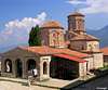
History of the place is very rich and reaches back to Hellenic times. Around the lake many cultural objects, mostly churches, can be found.
Prespansko Ezero can be accessed from Bitola, which is 35km away, or from Ohrid, that is some 45km away. Both lakes are also connected with mountain road that goes over Galicica massif via Livada pass (1568m). It is asphalted but narrower than normal road. Views from it towards both lakes are amazing.
 |
Ohridsko Ezero (Ohrid Lake)
 Ohridsko Ezero
Ohridsko Ezero (Ohrid Lake) is largest Macedonian lake. It is located in the SW Macedonia in so called Macedonian Lakeland. 2/3 of the lake belongs to Macedonia while other 1/3 belongs to Albania (SW corner). Although it doesn’t touch Baba massif as nearby Prespansko Ezero it also isn’t far from Baba and it would be a crime not to visit once here!
Ohrid Lake is legendary. Its name is known around the world. Ohridsko Ezero is one of the oldest lakes on the planet, along with Baikal in Russia and Tanganyika and Malawi in Africa and Titicaca in South America! It is one of those rare preserved ancient lakes and oldest in Europe. It was formed some 3.5-4 million years ago and is old tectonic lake. Scientists call it the museum of living fossils! It provided sanctuary for creatures from the tertiary period which died out elsewhere during the ice ages. The closest relatives of species like the endemic Ohrid Trout (Salmo letnica) survive only as fossils. There are also many other endemics in the lake. At some species ľ of those represented in Ohrid are endemics! Along with its fantastic natural value Ohrid is real cultural paradise with amazingly rich history. This was enough for UNESCO to add Ohrid Lake and Ohrid town to the list of UN World Heritage sites.
The facts. Along with nearby Prespansko Ezero and Dojransko Ezero Ohridsko Ezero is one of three tectonic lakes in Macedonia. Ohrid Lake was formed some 3.5-4 million years ago. At first Ohrid and Prespa lakes were one but rising of Galicica massif split them in two. Ohrid lake is 31km/19miles long, 15km/9miles wide and covers the area of 348km2/134miles2. So far maximum depth was 286m/938ft but recently point which is 310m/1017ft below surface has been discovered! Ohrid Lake is placed at altitude of 695m/2280ft. During summer water reaches temperature of 24°C. Water of Ohrid Lake is crystal clean; it is almost hard to imagine that such huge amount of water can be that clean in populated area. Water transparency reaches the depth of 22m! Since the shores of the lake are populated much is done to prevent pollution by building the water purifiers in larger places like Ohrid and Struga towns. Plan is that every village and house around the lake must be in the network of water purifiers to preserve this nature wonder.
Ohrid Lake is surrounded by high mountains from all sides; only south and north of the lake are small plains. Along the eastern shore Galicica (2287m) massif stretches. Galicica divides Ohrid from Prespa Lake. Along the western shores are also high mountains which belong to Albania along the southern part of western shore and Macedonian mountains along the northern part of western shore. In Albania it is Derven (1898m) while in Macedonia it is Jablanica (2256m). On the north is plain with Struga town, where Ohrid Lake looses water. North of the plain is Stogovo Karaorman (2240m) massif. On the south is similar plain between mountains. There is Albanian Pogradec town.
Because of considerable altitude and surrounding high mountains climate of Ohrid is mix between mild Mediterranean climate and mild mountain climate. Distance from the Adriatic Sea is 110km. Ohrid often sees snow in winter but it doesn’t last long on the lake level, while surrounding mountains are white from November to April or May. Average annual temperature at Ohrid is 11°C. In winter that average is 2.7°C while in summer 19.6°C. Summers on Ohrid are warm and usually not too hot. Maximum temperature measured is 35°C in July.
 Ohrid Lake gets water from many sources but most water comes from higher Prespansko Ezero lake, through Galicica massif. Most beautiful is source of Crni Drim (Black Drim) river, situated near the Sveti Naum monastery at the foot of Galicica massif and close to Albanian border at the SE corner of the lake. Source of Crni Drim covers few hectares of area. It is like a shallow lake, from 1-4m deep, filled with most clear water one can imagine. In it are 45 individual sources, some on the surface while some go through the bottom of the lake and you see them as boiling sand! They give 10m3 of water per second. Two rowing boats make sightseeing journeys of the source which last some 30mins. Don’t miss this! Water in the lake is completely replaced by the fresh water in 12 hours. Like a strong river water from the source spills into the nearby lake. Temperature of the water is 10°C but interestingly strong river goes straight into the lake and cold water doesn’t mix with nearby warm water. You can swim in warm 20°C water while meter away is strong current which has only 10°C! The other famous source by the lake is Biljanini Izvori (Sources of Biljana) at the edge of Ohrid town. They were named after Biljana girl, main character of one of most famous Macedonian tales. She used to wash laundry at the source, like other girls from Ohrid town, which was main transit centre between Adriatic and near east for centuries, since Roman times, from around year 150 BC. It was called Via Egnatia. Numerous caravans passed there every day and went to pick water at the source. Biljana fell in love with a man from one caravan although she was already promised to someone else. Today Ohrid town takes most of water from Biljanini Izvori so its strength is reduced significantly. Monument to Biljana on the source reminds of the tale.
Ohrid Lake looses water on the northern end, at Struga town. Crni Drim river comes out as strong river and continues its way towards Adriatic Sea.
 |  |  |  |  |
Ohrid Town
 Ohrid
OhridOhrid area is inhabited since Stone Age! To describe the history of the place in detail would take too much space but it would be a shame not to mention most important things in rich history of the area. Ohrid town was founded in 4th century BC. It is placed on the cliff/hill at the NE corner of the lake. Cliff is surrounded by fertile plain which is north of the lake, while mountains are close. This is best position for the town along whole shore of the lake. Its name then was Lihnidos (Lychnidos). Illyrian people who lived here then founded it. Name has Greek origin and means bright or sparkling. Lake had the same name. It was conquered by Filip (Philip) II of Macedonia. His son Alexander of Macedonia also fought wars with rebellious Illyrian tribes. In 148 BC Macedonia was conquered by Romans. Ohrid (Lihnidos) then became one of the most important towns of Roman Macedonia province. Since then it developed into rich city and very important traffic junction which connected Adriatic Sea (today’s Albanian port of Durres) with Thessalonica in Greece and today’s Istanbul in Turkey. That important trading route was called Via Egnatia. Antic theatre from 3rd or 2nd century BC which has 5000 seats witnesses of size and importance Ohrid had then. Christianity began to take its roots here in 3rd century. After the split of Roman Empire in 5th century Macedonia ended up in Byzantium state (Eastern Roman Empire). In the year 478 Eastern Goths penetrated into Macedonia and destroyed everything on their path. Ohrid was then rich and well fortified city. They didn’t manage to conquer it although long siege exhausted the town. It seams that even huge earthquake of 518 didn’t do as much damage to Ohrid as to rest of the country. In the time of huge movement of people Slavs came to Balkan. They reached Ohrid in 548. It seams that first wave of Slavic settling passed peacefully and that they managed to live peacefully with indigenous people. Macedonian Slavs lived in peace with Byzantium Empire. In 9th century Bulgarians conquered Macedonia. This resulted well for the Macedonian Slavs. Kliment and Naum began to spread the Macedonian Slavic language among the people. Macedonian was now used in literature too so this events detached Macedonia from Byzantium influence. They became the carriers of the culture of that time. Naum built the monastery in the SE corner of the lake in the year 900. After he died in 910 monastery was dedicated to him and is today legendary Sveti Naum (Saint Naum). After Bulgarian king Simeon died in 927 Bulgarian Empire began to fall apart till Macedonia found itself under Byzantium rule again in 971. But after 5 years rebellion is started by the sons of former prince Nikola who ruled before Byzantium came back. They liberated the country and then for the first time state of Macedonian Slavs was founded. One of the sons, Samuilo, became emperor. Under his rule Macedonia conquered new territory and covered lot of area, from Danube on the north till Greek Peloponnesus peninsula and stretched till Adriatic Sea on the west. He then proclaimed Ohrid to be patriarchate of the independent Ohrid church. This was of the main turning points in the history of town and Macedonia. But in 1018 Vasilije II conquers Macedonia again and brings it back under Byzantium rule. He destroyed town walls and burned the palace of Samuilo. Ohrid church was degraded but remained independent. Byzantium put their leading church man to rule here because local Slavs were self aware and educated. In 13th century Byzantium weakens so Ohrid changed rulers. In 1334 Serbian ruler Dusan Silni (Dusan the powerful) conquered Ohrid and annexed Macedonia to Serbian State. Most of the churches were built in the next period. When Dusan died local feudalists became stronger so Vukasin Mrnjavcevic took power. He led the first battle against coming Turks in 1371 on Marica. Macedonian army was defeated and he was killed. He was inherited by his son Marko who became Turkish vassal but he died in the battle near Rovin in 1395 when whole of Macedonia came under Turkish Empire. Ohrid church wasn’t shut down then but Turks gave it autonomy inside the empire. Till mid 16th century Ohrid was head of the Christian Orthodox Church for Serbia, Bulgaria, Italy, Sicily, Malta and Dalmatia. Some of the people turned to Islam under pressure of already Islamized tribes. Turkish Empire fell apart during Balkan wars and WW I. Then Macedonia joined the Kingdom of Serbs Croats and Slovenians which after the WW II became Yugoslavia. Since 1992 Macedonia is independent state.
Because of natural beauty and historical importance and heritage Ohrid town and the lake is leading tourist area in Macedonia. Here one can find numerous hotels, especially around Ohrid and Struga towns. In the Ohrid area there is more than 300 churches of which best known is Sveta Sofia cathedral from 10th century. Ohrid can easily be called city-museum with its mix of western, oriental and its own special architecture. Ohrid is also famous for Ohrid pearl. Making of it is long tradition here. Because of its value Ohrid town is proteced by UNESCO as World Heritage.
 |
Getting There
Center to visit Baba massif is Bitola town at the NE foot of the mountain.By Plane
Air gateway to Macedonia is capital Skopje or Ohrid, which is closer to Baba massif but doesn’t have that much traffic. More info about flights find on the site of Macedonian Airports.
By Bus
Buses from Skopje and Ohrid go to Bitola but also all these towns are interconnected with bus lines.
By Train
Railway connects Skopje and Bitola.
By Car
Skopje – Veles – Prilep - Bitola: 170km
Skopje – Tetovo – Kicevo – Ohrid: 175km
Ohrid – Resen – Bitola: 78km
Maps
There are no mountaineering maps in Macedonia at the moment. Road maps are good but there isn’t much help from them in the mountains. Here is road map detail which shows Baba area and two relief maps; one of wider area around Baba with Prespansko and Ohridsko Ezero lakes and the other of only Baba massif. On it I added the routes and position of Kopanki and Golemo Ezero Huts. At least it will give you some idea how they are dispersed and where the trailheads are. |  |  |  |
When to Climb
Although Baba massif is quite south on Balkan it is high and has quite harsh climate. Winters are cold and snowy. Crampons and ice ax are necessary then. Huts are open round year. You can reach Kopanji hut with a chair lift then. Summer and early autumn is usual time to visit Pelister, from July to October. In June in the high part of the mountain there can still be quite a lot of snow remains.Mountain Conditions
On the summit of the highest peak of Baba, Pelister, is TV building and tower but no meteorological station. Crew of the building probably monitors the weather and temperature but that is not professional so no data can be found in public. Solunska Glava (2540m) peak in the mid part of the country gives data of altitude weather. Because it isn’t far on the north (85km away) and has similar altitude temperatures are probably similar to those on Pelister.Russian weather server provides best current data for Solunska Glava. Best weather site, Weatheronline, gives accurate forecast and current data for quite close Ohrid.
Where to Sleep
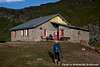
Kopanki Hut (1600m) is placed in the Molika Pine forest on the northern slopes of Baba massif. Hut is trailhead for two northern approaches. By car you can reach Molika Hotel. From it path leads to Kopanki some 30mins through the Molika forest. Kopanki hut is open year round. It has electricity and water. They prepare food and sell drinks. It has 80 beds.Molika Hotel (1420m) stands on the northern slopes of Baba massif and is surrounded by beautiful Molika Pine trees. It is reachable by car from Bitola via Magarevo village (14km). This is beautiful mountain hotel which has absolutely amazing interior, one of the most beautiful I’ve seen in my life and I’ve seen a lot! Hotel is open year round. It has 3 single bed rooms, 47 double bed rooms, 3 three bed rooms and 3 apartments. Full board in double bed room is 24.5€, half board is 22.5€ while only with breakfast it is 20.5€. If money isn’t a problem for you my recommendation is that you sleep over here. Kopanki hut is just easy 30mins above which won’t add much to the route to Pelister but you will sleep in dream hotel.
Golemo Ezero hut (2218m) is placed on the shore of Golemo Ezero (Large lake). Eastern route towards Pelister, which has a trailhead in Nizepole village, passes by it. Hut is open year round. In the kitchen you can prepare food while they sell drinks. It has water but no electricity. In the hut are 60 beds.
Don’t know about the camping but it is probably forbidden on the mountain since it is National Park.
 |  |  |  |
Mickovski - Aug 31, 2005 7:18 am - Voted 10/10
Untitled CommentCamping as well as any type of open fire are strictly prohibited on the grounds of the NP Pelister - the access routes to the NP territory prompt the visitors with huge billboards written in - cyrillics only!