March 19, 2006
Our honeymoon – a mix of a bit of work, a bit of school, and a lot of adventuring, was the fourth trip to New Zealand for me, the third for my beautiful wife Sonya (
ColoradoSonya), and our second together. Each time we visit we find many more reasons to come back, and our “to do” list keeps growing. This time around we spent two months on the South Island, living in Nelson for the first month and traveling about during the second.
We had been hoping for a chance to attempt the Ball Pass crossing in Aoraki / Mt. Cook Park in the first week of March, but were foiled by severe gale force winds (up to 120 km/hour in the valleys, and much worse higher up). Instead of waiting out what looked to be an extended period of foul weather in the park, we retreated down South to Fiordland to meet up with my parents, who had just arrived on the island to crash our honeymoon. To make up for this injustice, my parents generously supplied us with hotel rooms and dinners while we traveled together, a big upgrade from our accustomed tent-on-the-side-of-the-road and ramen travel style.
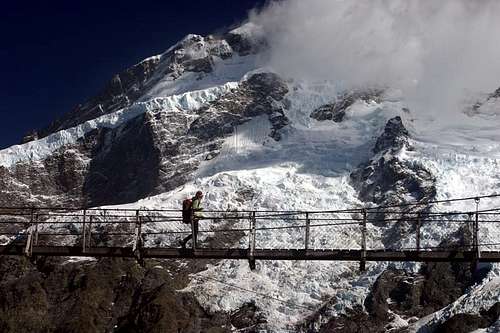
![Crossing the Hooker River below Mt. Sefton]() Sonya crossing the first footbridge over the Hooker River.
Sonya crossing the first footbridge over the Hooker River.Upon our return to Mt. Cook, we set out from the Whitehorse Hill campground at around 8 in the morning following the trail up the Hooker valley. The weather outlook was great for the next day and a half, which would hopefully allow us enough time to climb up the Hooker valley, camp on the pass itself and get safely down to the Tasman valley below before the low pressure system settled in. We crossed the first scenic footbridge under the enormous face of Mt. Sefton, illuminated by the morning sunlight. At the second footbridge over the Hooker River, we parted company from my parents and sidled along a climber’s trail across a steep scree-covered face on the river’s true left. From this point on the Ball Pass crossing becomes an unmarked route rather than a trail, which helps to maintain a sense of wilderness apart from the busy path on the other side of the river.
![Ascent of Gully from Hooker Valley, Ball Pass]() Climbing up the gully
Climbing up the gullyThe route finding was reasonable amongst tussock-covered slopes, shingle fans, and the occasional small stream crossing as we followed sporadic cairns up the valley. We ate a quick lunch before heading up a scree and boulder filled gully to the northeast. Here we crossed paths with a guided party descending the gully, and envied them as they cruised downwards, free from the misery provided by the slippery scree. The gully ascends relentlessly up to a level grassy area (the “playing fields”) that came as a great relief and reward for all the toil in the gully. The spectacular view across the valley from this small plateau takes in Mt. Sefton and La Perouse, with the low peak of Mt. Cook looming high above. Clouds piled up along the West Coast poured over the divide before evaporating in a mist across the glaciers. We reluctantly continued on, and zigzagged up and across a series of ledges before dropping back down the other side of a ridge below Mt. Mabel. This section of the trip was one of the trickier bits of route finding on the crossing, and would have been quite difficult in less than ideal weather conditions.
![Above A Crevasse, Ball Pass Route]() Crevasse
CrevasseFrom here on the pass itself was clearly visible, and our only difficulty was finding enough energy to lug our packs up to the foot of the small glacier just below the pass. Here we strapped on our crampons, and continued upwards, passing a couple of small crevasses on the climber’s right. One final scramble up yet another scree slope put us on top of the pass, and we were thrilled to look out over the Tasman Valley as the sun began to set. We set up our camp on a small clear patch just above the pass, and Sonya cooked us up a tasty cheesy noodle dish as I organized the tent. We briefly visited with our neighbors camped below on the glacier – three friendly guys from Christchurch who had come up the Tasman side and supplied us with useful route information for our descent.
The stars started to come out as we headed back up to our little yellow tent, and I spent a few minutes taking nighttime pictures of Mt. Cook from the pass. I noticed some mist beginning to form below on the Tasman Glacier, and in fewer than three minutes visibility was reduced to zero on the pass. I took this as a hint and wandered back into the tent, where Sonya was busy warming up our sleeping bags.
March 20, 2006
![Caroline Face of Mt. Cook]() View from Ball Ridge
View from Ball RidgeThe next morning we were treated to a fantastic red sunrise, after which we hurried to eat a tasty oatmeal breakfast, pack up and head off down the glacier into the Tasman Valley. Walking across the glacier beneath the morning sunlight on the Caroline Face of Mt. Cook was definitely one of the highlights of our trip. After numerous photo stops we gained the Ball Ridge, took a break to strip down some layers of clothes and take off the crampons, and continued down the ridge. This section of the route more or less follows the ridge crest, but in poor visibility conditions could make for extremely difficult travel.
![Closeup, Caroline Face of Mt. Cook]() Closeup of Caroline Face
Closeup of Caroline FaceAfter a steep scramble down a loose rocky spur we reached the Caroline Hut, two hours after we left the pass. We continued our descent, searching for the occasional ambiguous cairn (route finding was especially tricky just below the Caroline Hut) and steadily losing altitude. All the while the Caroline Face reared above us, rumbling with frequent serac falls and avalanches. As we continued down Sonya remarked how lucky we had been to avoid any gusty wind, which of course was the immediate cue for the wind to sweep across the ridge. A series of steep descents consisting of alternating short scrambling sections with longer segments along a more well defined path led us to the Ball Shelter and the valley floor.
From the precariously perched Ball Shelter (situated on a collapsing moraine wall) we trudged along the old road, which itself has slumped down the moraine at numerous points. Two hours later we arrived, hot and exhausted, at the Blue Lakes car park. Here we hitched a ride back to Mt. Cook village from a very friendly retired couple on holiday from Christchurch in their RV. The travelers were quite excited to hear where we had arrived from, and we were congratulated with a number of “good on ya’s!” Good on them for helping out a smelly pair of honeymooners!


Comments
Post a Comment