
|
|
Mountain/Rock |
|---|---|
|
|
39.07300°N / 79.298°W |
|
|
Grant |
|
|
Hiking |
|
|
Spring, Summer, Fall, Winter |
|
|
4091 ft / 1247 m |
|
|
Overview
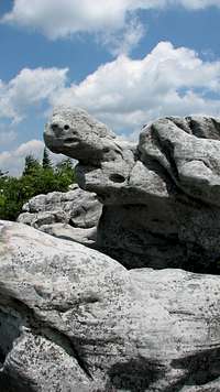 Sandstone formations.
Bear Rocks are at the northern border of the very popular Dolly Sods Wilderness, adjacent to the Dolly Sods Scenic Area in the Monongahela National Forest. The Rocks are typical of the high, scoured ridgelines that resemble a sub-alpine environment. No such true sub-alpine ecosystem exists in this area, but the Sods are a pretty darned good imitation of such.
Like The Sawteeth and Charlies Bunion in the Great Smokies, and Grayson Highlands in southwestern Virginia, these high elevation, wind-swept vistas are the product of clear-cutting followed by devastating fires followed by heavy downpours. The clear-cutting left behind the shattered remnants of trees, creating tinder that quickly dried. Lightning or other causes started fires in these clear-cut areas that burned the vast, thick, peaty topsoil that had lain undisturbed beneath towering forests of virgin spruce and balsams for 10,000 years. This organic soil burned as readily as the drying limbs and trunks left by the lumber companies and billowed into soot all the way down to the bare rock and mineral soils beneath. The thunderstorms that followed washed away what soil remained and so the mountaintops of what we now know as Bear Rocks and Dolly Sods were left to slowly recover, beginning the process of reforestation that had first begun after the retreat of the glaciers more than ten thousand years before.
 Open vistas.
Bear Rocks are composed of sandstones and conglomerates and are strikingly pale among the heath-like shrubs and stunted evergreens along the 4,000-foot slopes. After almost 100 years, the vegetation is beginning the painfully slow process of reforestation. Most of what you see growing around Bear Rocks are blueberries and huckleberries along with red spruce trees stunted by the severe winter weather and the almost constant winds that scour this part of the Allegheny Front. There are no established trails here, but the locals gather all along the Front in the summer months to harvest berries, and so the heaths are a maze of many trails.
 Near the summit.
The views from Bear Rocks on a clear day unimpeded by smog are amazing. One can see range after range extending eastward all the way to Shenandoah National Park at times when air pollution is at a minimum. In all other directions, visitors can view the local high peaks and the vast plateau upon which these fantastic lands lie. South of Bear Rocks is the Dolly Sods Wilderness Area where there are many miles of established trails weaving in and out of valleys, steam beds, and along ridgelines much like those at Bear Rocks. Standing along the meadows around Bear Rocks, it’s not hard to understand why this area is among the most popular hiking destinations in the entire state of West Virginia.
Getting There
 Forest Service Road 75.
Red Tape
None. Bear Rocks are open to the public. Respect the land.Camping
There is ample backcountry camping available in the adjacent Dolly Sods Wilderness Area. The Red Creek Campground is also along Forest Service Road 75 just a few miles south of Bear Rocks. Rustic camping with picnic tables, lantern posts, vault toilets, and potable water source.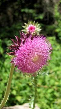 Thistle.
External Links
Dolly Sods Wilderness.Bear Rocks Preserve.
Red Creek Campground.
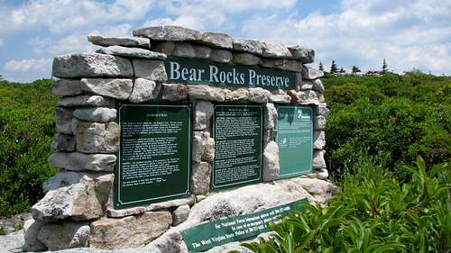 Nature Conservancy sign.
sopwith21 - Oct 18, 2013 1:19 pm - Voted 3/10
Need Actual Hiking DetailsThis page is very good for explaining the theories of why the land came to be as it is, and a description of the vegetation. But adding actual hiking details is paramount to those of us who want to visit. Parking information... how long is the hike... how many hours should be set aside for it... how strenuous is it... is there an established trail (apparently not?)... if so, how to find it... if not, what route, what side of the ridge, is one route superior to another... is it all obvious when we get there?? All these details would be very helpful to those who have not been there and would like to plan a trip. Thanks for making this page!
BobSmith - Oct 18, 2013 4:04 pm - Hasn't voted
Re: Need Actual Hiking DetailsOkey doke! I'll see what I can do. There wasn't much in the way of established trails as I recall. Just manways all through the vegetation where people go to pick the blueberries.