
-
 16169 Hits
-
 81.17% Score
-
 13 Votes
|
|
Mountain/Rock |
|---|---|
|
|
47.83070°N / 7.80580°E |
|
|
4639 ft / 1414 m |
|
|
Overview
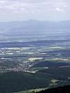
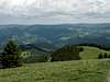
With its height of 1414m it is only the fourth highest mountain in the Black Forest, after Feldberg (1493 m), Seebuck (1448 m) and Herzogenhorn (1415 m), but it is the most beautiful one. The view from here on wooded mountains and valleys in the Black Forest and on the Rhine valley with the Vosges behind is wonderful.On clear days you can see the Alps. Above the timberline you will find a sub alpine flora, plants like the mountain campanula and foxgloves. The slopes facing the north are covered with pine trees but the ones looking to the south are either covered with rocks or you find meadows and light beech forests.
In the Alemannic language "Belchen" means a mountain without a peak only with a hilltop, rounded off like a dome which often is bare.
There is not only one "Belchen" but quite a few, in the Black Forest, in Switzerland and in the Vosges because we are in a highland region.
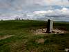
Belchen is not a difficult climb, there are lots of hiking trails you can follow. A road ends at the "Belchenhotel" which comes up from the northwest, the "Wiedener Eck" or from the southeast from "Schönau". Since the construction of the cablecar, this road is forbidden for cars. At the top there is a circular walk on which you can go right round the dome.
Web cam of Belchen
 |  |  |  |  |
Getting There
- From Karlruhe you reach the Belchen-Seilbahn (cablecar) over highway A 5. Exit Bad Krozingen direction Staufen - Münstertal to the collar Wiedener Eck and follow the signs "Belchen-Seilbahn".- From Basel road B 317 direction Schönau and follow the signs "Belchen-Seilbahn".
- From Titisee-Neustadt road B 317 to Schönau.
 |
Red Tape
The Belchen summit road is forbidden for cars since the construction of the Belchen cablecar.When To Climb
All the yearRoutes Overview
- Summit roundhikeDiscover the summit of Belchen in 30 minutes. Follow the direct path from Belchenhaus to the summitcross.
- Nature path
Follow the signs which explain the nature and you reach the summit in 40 minutes
- Panorama path
Tour of the summit in 1 hour with nice views on Freiburg and the Münstertal, 1000 meters lower.
- Path of the virgin forest
Walk through the Belchen-Bannwald to the cablecar departure in 70 minutes.
- Hochkelch-Haldeweg:
Walk from Haldenhof over Hochkelch (1.266 m) to the summit (6 km, 2 hours)
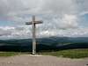
Summit View
From the Belchen, you have a sweeping view over the Black Forest.- in the west, the Rhinevalley and the Alsacian plain in France with the Vosges in the back.
- in the south, the Swiss Jura.
- in the north, the innumerable summits of the Black Forest.
- in the south the Wiesental just below.
If the weather is clear, you have a magnificent view over the Alps from Zugspitze to Montblanc.
 |  |  |  |  |
Camping/ Hotels
Camping on the Belchen is not allowedNearest camping : Schoenau Camping Schoenenbuchen home page
Belchenhotel "Jägerstüble"
Günter Dietsche
79677 Aitern-Multen
Tel . 07673 / 7255
Fax 07673 / 7884
Hotel-Restaurant-Café "Belchen-Multen"
Fam. Demmler
79677 Aitern-Multen
Tel . 07673 / 209
Fax 07673 / 7039
Belchenhaus. Built in 1898, highest hut in Baden-Württemberg
 |
Mountain Conditions
See Belchen home page :Mountain conditions
"Belchism"
On the mountain tops the Celtic people who originally inhabited this area used to worship the sun as a deity which was called "Bellenus". The Celts did that especially on the longest and the shortest day and on the days when day and night are of the same length. This means they followed a kind of sun calendar. From this mountain called "Belchen" in the Black Forest you can see the sun rise directly above another mountain also called "Belchen" in Switzerland on the shortest day of the year. When day and night are of the same length which happens twice a year in spring and in autumn, then you see the sun set at the "Belchen"(Grand Ballon) in the Vosges.Is that a coincidence? It probably is. But for the Celtic people this coincidence was of great importance.
If you want to see for yourself if it is correct what I am saying here then climb to the top and check on these peculiarities on 21st December, 21st March or 23rd September.
Geology
In primeval days the whole region of the Black Forest - including the Vosges on the other side of the Rhine - was covered by an ocean whose sediments of muschelkalk, keuper and Jurassic limestone covered the granite and gneiss.After that forces from within lifted the region, the ocean disappeared and the sediments formed a huge dome which could not resist the pressure. As a consequence a long rift formed - the Upper Rhine Valley.The southern region of the Black Forest - the right rim of the rift - was pushed up higher than the northern region, that is why the highest mountains are to be found in the south:" Feldberg" 1493m, " Herzogenhorn "1415m and "Belchen" 1414m high.
In the course of time the upper layers of sediments were completely removed by erosion in the south during millions of years so that granite forms the surface here. In the north red sandstone covers the granite and gives the region a different character. The soil is not fertile and that is why we mainly find fir trees here which can grow on poor soil. Beach or oak trees are rarely to be found.