
|
|
Canyon |
|---|---|
|
|
41.18082°N / 111.90315°W |
|
|
Hiking |
|
|
Spring, Summer, Fall, Winter |
|
|
Overview
 Beus Canyon in the Fall
 Yup...that's the Trail! Fern Fields give the Upper Beus Canyon a nice Jurasic feel. Raptors?
 Cross Road 1/2 mile up trail...continue on right fork across bridge
Beus Canyon, at the top of Ogden's 46th street, is a non-technical USFS canyon trail running along Beus Creek and is part of the Great Western Trail. Even though the trail is the primary route for attempting Mt Ogden from the west, the canyon is interesting in and of itself. Beus Canyon trail routes through forest, crosses Beus Creek several times, and goes through thick fern fields for a total distance of about 2.5 miles before it turns south and goes steeply up the mountain side (that’s the route to Mt. Ogden). Trail traffic is surprising low even though it is close to the city.
While Beus Canyon is a place hardcore climbers blow through on their way to climbing Mt. Ogden, for "stop-and-smell-the-moose-crap" summitposters, it is a cool and scenic diversion. It is prime for summer hiking as the forest tends to be about 10 degrees cooler than the city. During the fall, you get some nice leaf changes and fall coloring without the effort of driving into the mountains. The trail gets plenty of traffic during the winter and you shouldn't need snowshoes on the lower portion of the trail (although it does get icy and snowshoes could be handy). Spring comes a little later to Beus than the rest of Ogden because of the natural shading of the forest; expect snow to be present thru April.
Overall, the trail is straightforward and doesn't have a lot of side trails that confuse the heck out of people. All cross-road/side-trail issues are solved with "Keep Right/Go Up". There is only one trail from the trailhead and you pass an info kiosk and sign that says 5.6 miles to Ogden Saddle. From there, the trail goes steadily (but not steeply) up the canyon. At the 1/2 mile point the trail splits with the left fork going onto the Bonneville Shoreline Trail and all Ogden points North. The Right Fork (stay on this) crosses a bridge and continues into the canyon. At about 1 mile, you will reach a small 25 foot waterfall next to the trail. Continuing up, you cross the creek twice and the forest becomes more Aspen and less Oak. At about 2 miles, you will reach the fern fields that go for about another 1/2 mile...these fern fields are incredibly thick, you may need a machete in the summer. During the fall, the fern feilds are much less imposing and the trail is easy to navigate. Recent trail maintenance has greatly improved the trail above the waterfall and widened the trail through the fern feilds. Once you run out of fern field, you've ran out of canyon. From there, the trail goes steeply up the side of the mountain (south) and up to Mt Ogden (About 3 miles to the North East).
Getting There
 Crossing Beus Creek in the Forest
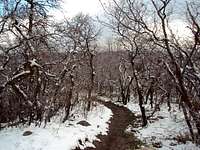 Beus Canyon trail
From I-15, take exit 341 toward 31st St, follow signs for Weber State University. After 1.2 miles merge onto UT-79 E/31st St. Turn right at US-89 S/S Washington Blvd. Turn left at 40th St. Continue onto Country Hills Dr. Turn right at S 1200 E St/Harrison Blvd. Turn left at E 4600 S. E 4600 S turns slightly right and becomes S 1900 E.
The Trailhead is on the left next to a small Forest Service building.
In general, once you reach Ogden, you head toward Weber State, get on Harrison Blvd, head south until you reach 4600, turn East toward the mountain, Beus Trailhead is at the top of 4600 Street next to the USFS building.
The trailhead doesn't have water or bathroom facilities. There is parking for about 10 vehicles but doesn't have much space for horse trailers (but I've never seen a horse on the trail anyway!). The Info Kiosk has a poster map of the area and some historical info about the trail. See https://www.summitpost.org/beus-trailhead/699629 for more info.
Red Tape
None. US Forest Service Land.Pursuant to a whole herd of US Government Regulations, avoid making non-standard trails, be careful with campfires, don't annoy the wild animals, and recreational use pharmaceuticals on Federal property is frowned upon.
No motor vehicles are allowed on the trails but watch out for mountain bikes.
Camping
There are very few "good" camping locations in Beus Canyon. Since the trail runs along a creek, there is plenty of resupply should you decide to spend the night.Since the hike is fairly short, few people actually camp along the route.
Flora and Fauna
 Beus Creek along trail
Despite being very near Ogden, Beus is full of wildlife. I've been nearly ran over by moose twice, seen bobcat tracks, been attacked by a rabid squirrel and had the bejeusus scared out of me by wild turkeys and grouse. And, of course, keep an eye out for rattlesnakes. Like most North Utah forests, bugs aren’t too much of a problem and you shouldn’t need much more than Off bug spray to keep them at bay.
Flora is pretty typical of North Utah forests and thickly lines the trail. The trail is heavily forested with Gambel oak, Canyon Maples and Aspen for the first 2 miles. After that, you will reach a massive fern field that goes for about a 1/2 mile (no kidding, this looks like Jurassic Park in the summer).