Punakha to Paro 16 Day Trek
“Good morning!” “Coffee, tea?” I rolled over in my sleeping bag and shouted “coffee, please”. I had grown accustomed to this morning wake up call over the past two weeks. The camp staff delivering hot beverages to my tent would be unfailingly cheerful whether it was drizzling rain, bitter cold, or bright sun. It was impossible to guess the weather conditions until I unzipped from the cocoon of my sleeping bag and gazed outside. Today was the most anticipated day of my sixteen day trek in Bhutan; I desperately hoped for clear skies.
As I scramble to unzip the frost-laden tent, I discover both my water bottles are frozen solid. Night time temperatures tend to be chilly when camping at 13,500’ elevation. When I stick my head out of the tent into the brisk morning air, I’m astonished by the brightness of the view. The sun is shining directly on the white snows covering Chomolhari (23,997’). I have to squint as I take in the spectacle of the majestic peak surrounded by brilliant blue sky. Yes, this will be a birthday I will always remember.
For years I have been fascinated by the pictures in travel brochures--of Bhutanese in traditional dress, Himalayan scenery, Buddhist monks, and unique architecture. In 2006 I learned that the
King of Bhutan had announced a transition to democracy, scheduled to occur in 2008. I knew I had to see Bhutan in its pristine glory, before the “global economy” and other Western influences drive the traditional culture to fade away.
I struggle to focus my sleepy eyes on the blinding white glaciers blanketing Chomolhari. Unlike other high Himalayan peaks, there is no reason to retrieve binoculars and scan the slopes for black specs indicating ascending climbers. Climbing the snow-capped peaks in Bhutan is forbidden, lest you “disturb the spirits”. That may explain why Bhutan contains the highest unclimbed peak in the world ---Gangkhar Puensum (22,623’). With nearby Nepal charging thousands of dollars for alpine permits, would the newly democratized people of Bhutan vote to reverse ban on climbing? Will the citizens of Bhutan uphold the King’s decree that “Gross National Happiness” takes priority over “Gross National Product”? How will Democracy affect the pristine environment I’ve observed for the past two weeks? Next year’s trekkers could find a base camp crowded with aspiring climbers and climbing gear, instead of the serene and unspoiled landscape I am currently enjoying.
Bhutan is situated in the Himalayas between Tibet and India. Bhutan, or "Druk Yul," means Land of the Thunder Dragon. Tucked within the highest mountain range on earth, Bhutan was long kept secret from the rest of the world. At 17,954 square miles, Bhutan is the size of Switzerland. Surprisingly, guidebooks indicate that it takes two weeks of driving to traverse the country west to east. Of course, that depends if the one vulnerable cross-country road is blocked by snow (in winter) or landslides (in summer).
Bhutan may be small in size, but it is rich in bio-diversity and culture. Bhutan’s landscape varies from tropical valleys to alpine peaks, with deep rivers flowing from north to south. Almost all roads throughout the country are one lane dirt roads, rising and falling great distances as they hug the mountainsides or traverse the river valleys. Rugged mountains dominate the terrain and make the building of roads difficult and expensive. I witnessed people rebuilding roadbeds by painstakingly breaking rocks into smaller pieces using only a small hammer. There are no traffic lights in the entire country of Bhutan!
Culturally Bhutan has no parallel. For many centuries, the Himalayan Mountains isolated Bhutan so that its language, society and social customs developed with little external influence. Mahayana Buddhism permeates and inspires all of Bhutanese life. Hunting, fishing and the sale of tobacco is prohibited. Prayer flags and religious structures dot the landscape. A major attraction for tourists is attending one of the Tsechu ceremonies. In contrast with many other countries, Bhutan's ceremonies are not relics of the past - they are still important aspects of everyday life.
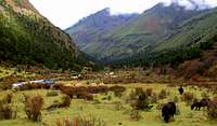
The best way to see Bhutan’s natural beauty is to go trekking. Unlike backpacking, trekking involves only carrying a light day pack. Heavy gear and food is transported by pack animals, so trekkers can enjoy the landscape without the hassle of shouldering a heavy load. On organized treks, a crew is hired to cook meals, purify water, and assemble the tents. I chose a trek from Punakha to Paro; a sixteen day trek in a completely road-less region of the country. At times I would walk four days between villages, with only a few scattered yak herders’ huts between settlements.
Day 1: Tashithang to Gem Damji
![Punaka Dzong]() Punaka Dzong
Punaka DzongOur group was transported by van on the muddy road through Jigme Dorje National Park. The road now ends at Tashithang (5,800’), but construction is underway to extend the road to Gasa. This short first day of trekking brought us from the lush subtropical rainforest of the valley to the high agricultural terraces above the Mo Chu (“Mother River”) at 7,325’.
Day 2: To Gasa Hot Springs
![Gasa Dzong]() Gasa dzong
Gasa dzongUpon awaking I was horrified to pull a leech from my skin-– my first outdoor leech experience. The muddy trail wound through rolling hillsides, with vistas of villages and fields set against oak and pine forests. We passed monks traveling in the opposite direction. At mid-day, I glimpsed Gasa Dzong perched on a mountainside in the distance. The Dzong was built in the 17th century by King Shabdrung Ngawang Namgyal to protect the valley from Tibetan invaders. After crossing a well-built suspension bridge, we reached Gasa Hot Springs (7,238’). At one time these springs were improved with cement troughs and wooden tubs. But as it is in most third world countries, the springs were not maintained. The area is in dire need of repair and trash removal, but this does not deter the local residents. I made up for the morning’s parasitic insect attachment by spending three hours relaxing in a hot spring. That would be my last time to soak in hot water until I departed Bhutan three weeks later.
Day 3: To the town of Gasa
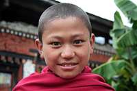
![Monks in Gasa]() Young monks
Young monksIt was a half-day uphill climb to the town of Gasa. When visiting Gasa Dzong, curious young monks wearing traditional red robes overcame their shyness to try on my sunglasses. “Dangerous!” one of them shouted in English as he flaunted the shades to his fellow monks. It was astonishing to observe how something as simple as sunglasses could amuse the austere holy boys for hours.
Day 4: To Koena
![Young monk]() Young monk
Young monkToday was the longest day of the trek, so we had an early start. We climbed steeply through bamboo, juniper, and rhododendron forest to the shoulder summit of Bale La (12,350’). After descending on the other side, we snaked along the side of the Mo Chu river. It rained most of the day. Around 4 PM, we reached Koena. Lonely Planet calls Koena “the worst campsite in the entire Himalaya”. It is a muddy bog with a small dormitory. After one of our group members fell in the mud, we opted to continue trekking. About 1 ½ hours beyond the filthy camping area was a nice (but very small) flat spot beside the Mo Chu River. We did not reach the campsite until it was dark. Without headlamps, the area was pitch black. It was very easy to get disoriented and lost if you did not have a torch. Since everyone in our group was drenched from the day’s rain, hypothermia was a concern. Upon awaking, we discovered why our camping area was flat. The level area was actually a run off diversion stream of the Mo Chu River. Fortunately the river did not rise high enough to wash our tents away during the night.
Day 5: to Laya
![Bridge over Mo Chu]() Mo Chu bridge
Mo Chu bridgeThe trail continued to gain in elevation. We passed through a Bhutanese army outpost, where our group leaders were required to show paperwork. After snapping a few pictures with my camera, I was urgently instructed to cease taking photos.
In late afternoon, we reached Laya (12,610’). This is one of the highest settlements in Bhutan. The women of Laya are recognizable by their conical bamboo hats with a center spike of bamboo. It was also unusual to see the long hairstyles on these women, since women in the rest of Bhutan keep their hair short. Laya’s men wear distinctive black woolen coats.
Day 6 Laya exploration Day
![Laya young woman]() Laya woman
Laya womanThere was plenty to explore around the fascinating village of Laya. I visited a monastery, a school, and the only health clinic for 4 days of walking. I was fortunate to be able to visit inside one of the homes. Later in the afternoon I hiked up the nearby hills and looked for bouldering areas. There were fantastic views of Mount Masang Kang (23,604’).
I saw a woman washing clothing in the stream and attempted to communicate with her. Using mimes and gestures, I only succeeded in exchanging smiles and giggles. I wondered if this happy woman was aware of the upcoming changes in her country’s government, and if the rumors I had heard are true. I had been told that people in Bhutan love their King, and are very sad to be pushed into Democracy. But wouldn’t this woman aspire for the simple improvements electricity could bring (such as a washing machine)? If a politician promised modernization for rural villages, would they win the local election? Or would people vote to prolong their primitive but peaceful lifestyle?
Since no roads exist, all items destined for the communities I visited are transported by mule or yak (at high altitudes). Exploring the remote villages made me feel as though I had used a time machine to reverse the last 400 years. There is no electricity, running water, or machinery of any kind. Animals continue to be used to plow the fields. In spite of everything, the barter economy dominates – isolated and unchanged. Most villages have a monastery or Dzong where monks worship as they have for centuries. The march toward modernization has eluded this deep-rooted land of the monarchy. I felt under the spell of tranquility as I traversed the countryside where time seems to stand still.
Day 7: to Limithang
![Lamithang]() Limithang
LimithangThe trekking route led to increasingly higher elevations. Bhutan is covered by all climatic zones, starting from sub-tropical jungles in southern Bhutan (bordering with India) to high alpine plateaus. On the trail, I would occasionally pass a local resident walking the opposite direction. I was bundled up in Gore-tex® to protect from the occasional shower, but the Bhutanese wore traditional dress – a “gho” for men and a “kira” for women. Their clothing did not appear to be rain resistant, but I was always met with smiles and “Kuzuzangbo” or “Hello!” Dzongkha, the national language, uses the same script as Tibetan. Although their histories are intertwined, the spoken words if Dzongkha and Tibetan are different. English is the official working language, and both English and Dzongkha are taught to children in Bhutanese schools.
We reached the Limithang Valley directly below the huge peak called Gagchen Tek (22,291’), the Tiger Mountain. Camp was at 13,250’.
Day 8: to Robluthang
![Shinche La]() Shinche La
Shinche LaEvery day of trekking now would involve climbing over at least one windy pass; each high point crowned with differing arrays of fraying prayer flags. Day eight was difficult, climbing in wet conditions to Shinche La Pass (16,400’). The pass offered stunning mountain views, and we were fortunate to see bharal (blue sheep) grazing as we descended the other side. Later we found a recently killed deer carcass. We assume was attacked by a snow leopard, since there are no other large carnivores at this high altitude.
After eight days of trekking, I was amazed to see such little human impact on such a vast area of pristine countryside. The natural environment is seen as the living place of gods and spirits and is revered by the people of Bhutan. Seventy-three percent of Bhutan is forested because the country has allowed only sustainable development. A permit is required to cut down any tree. Rivers and lakes are pure and endangered species are protected. Bhutan is reported to have 165 species of mammal including the endangered takin, langur, and very elusive snow leopard. Bhutan supports more than 5,000 plant species, including some 300 medicinal plants and 600 types of orchids. Six hundred and seventy five different species of birds have been identified; the most popular being the black-necked cranes that winter in Bhutan.
After a very long day with a few stream crossings, we reached our campsite at Robluthang (12,965). Above the campsite were the crumbling ruins of an old Dzong.
Day 9: to Shamuthang
![Takin]() Takin
TakinDirectly outside the campsite, we traversed “protected Takin habitat”. Takin is the national animal and looks somewhat like a stunted moose. At Jari La pass (15,550’), I dashed up a side summit while the rest of the group gathered for lunch. I had the irresistible urge to summit something, anything, on this trip. The Himalayan views were stunning.
A long descent through rhododendron forests brought us to a riverside camp at 13,026’. The camping area was on an incline. I found a memorial Chorten for a trekker who expired on Oct 9, 2007. We only know the camp staff could not wake her in the morning.
Day 10: To Chebisa
![Chebisa]() Chebisa
ChebisaAt Gombu La pass (14,604’), we were fortunate to see a griffon flying overhead. The weather held and the views were impressive. Another herd of bharal was sighted before we reached Chebisa (12,710). Once in camp, I opted to bushwhack to a nearby waterfall. The exploration was notable for the number of yaks and barking dogs I had to evade. Some responded to airborne rocks; others required large detours. When I returned to the campsite, I learned the Bhutanese Army tent behind us held four prisoners accused of smuggling.
All new construction in Bhutan must conform to the old style of architecture. The country's magnificent architecture forms a significant part of the Bhutanese identity; you will not see any modern buildings when visiting. The structural design is striking especially when you learn that neither blueprints nor nails are used in construction. All homes have distinctive pressed earth (mud) walls supported by heavy timber frames. The building’s exterior is then painted white; while exposed wooden beams are meticulously decorated with elaborate symbols and designs. Goenpas (monasteries), Dzongs (fortresses), Lhakhangs (temples), and Chortens/Stupas (religious monuments) all incorporate this unique architecture.
Day 11: To Lingshi
![Lingshi Dzong]() Lingshi dzong
Lingshi dzongThe trek continues as a pleasant routine of hiking each day through changing alpine scenery. Spending weeks without modern conveniences and distractions had an unexpected and profound effect on me. I acquired a tremendous sense of serenity which has persisted to this day. Perhaps I no longer feel the same intensity of desire toward material possessions. The people of Bhutan lead joyful lives of simplicity, unlike our complicated stressful way of life.
We passed through the village of Gom Yu and a striking monastery cut into the cliffside. After reaching the community of Lingshi, we lunched at the post office in an effort to keep out of the rain. A steep ascent led us to Lingshi Dzong, a mystical looking structure built on an improbable hill surrounded by mountain views. The front rock wall of the dzong had tumbled and the building was in disrepair. Astonishingly, the monks were rebuilding a Chorten some distance away instead of reinforcing the Dzong where they resided.
We camped at 13,196’ with spectacular views of Jichu Drake (22,930’).
Day 12: to Jangothang
![After Nyele La]() Trekking
TrekkingTrekking at the higher altitudes was like changing to a panoramic camera lens. The expansive clear sky opened up, and the views became colossal Himalayan vistas. Each new bend in the trail would reveal different aspects of gigantic mountains, with immense white glaciers clinging to the jagged slopes. The trekking route led from Jichu Drake to Jangothang (“land of ruins”)—otherwise known as Chomolhari base camp.
When camping, competing forces conspired to keep me awake most nights. The dogs in Bhutan sleep all day and bark all night. When camped near a village, I was guaranteed to hear barking dogs most of the night. In the alpine highlands, yaks would grunt sounding similar to a 2000 pound person snoring beside my tent. Other nights I was serenaded by the jingling bells worn by our ornery pack mules. The most uncomfortable nights were those spent on inclines. In an effort to keep horizontal, I would wedge my belongings below my feet inside the tent door. At times it felt as though I was sleeping standing up (on my duffel bag). A few lost hours of sleep is a small price to pay for this once-in-a-lifetime cultural and outdoor experience.
Day 13 Chomolhari Base Camp (13,500’)
![Bharal]() Bharal
BharalAlthough billed as a “rest day”, my mileage exploring the surrounding areas surpassed that of most trekking days. I visited beautiful Sopu Lake, an alpine lake in which fishing is prohibited (as in all of Bhutan). In order to regain some merit, I worked to pull some wet prayer flags out of the river and rebuilt the supporting pole. I was happy to see the dry prayer flags still flying when I returned later in the day.
Tourism in Bhutan did not begin until 1974, and is still heavily managed by the government. Bhutan's tourist policy, "low volume, high quality," reflects the country's desire to avoid the negative impacts of tourism on culture and environment that have affected other developing countries. Tourists must plan their visit through accredited private travel agencies, apply for visas through the travel agencies, and pre-pay $200/day (or more) for their stay. Travel is only restricted in some remote parts of the country; visitors may freely walk through most towns and villages and mingle with local people. In 2006, Bhutan had 18,000 tourist visits.
Despite the lack of infrastructure, travel restrictions may be lifted according to the will of the people when the democratic process begins in 2008. One obstacle to increased tourism is the limited airline access. Druk Air, Bhutan’s only commercial airline, normally schedules just one flight into Bhutan each day. The air strip is set in a narrow valley 7,300 feet above sea level. The surrounding hills are high as 16,000 feet. The approach into Paro airport involves a 30 degree turn at the last moment and is entirely by visual flight rules. Flights may be cancelled if clouds obscure the valley, an increased concern during the monsoon season.
Day 13-14 Thangthanka, Sharna, then onto Paro
![Alpine Lake]() Alpine Lake
Alpine LakeAfter weeks spent in high altitude, it only took two days to descend back into the cover of trees once again. As I trudged along—cognizant I was nearing the end of my trek – I was greeted again and again by smiling and waving children beside the trail.
Autumn is the traditional high tourist season in Bhutan. The snow has melted on the high passes, and the summer monsoons have ended. September and October months have the highest number of festivals. The rice harvest season in the fall produces landscapes of remarkable terraces and changing colors. Bhutan grows red-colored rice which is purported to have a higher nutritional value than white rice. Food in Bhutan is an exciting mixture of hot Himalayan flavors - Tibetan, Chinese and Indian. Bhutanese prefer vegetables, rice, chilies and more chilies. The nation dish is Ema Datse - cheese and chilies. Chilies are not just a spice, they are the entire meal!
After the trek had concluded, I spent one day in Paro visiting Bhutan’s most famous landmark—the Tiger’s Nest. The Tigers Nest (Taktshang Goemba) is an ornate monastery perched on a cliff. Legend has it that Guru Rinpoche, who brought Buddhism to Bhutan, flew in on the back of a flaming tigress and landed on this spot. The only way to visit Tiger’s Nest is to hike two hours uphill or ride a horse (unless you know how to find a magic tiger). Bhutanese written history begins in the 17th century. All other history is legend, folklore and myth passed down through generations.
Despite its tradition of self-imposed isolation, Bhutan will transition from a monarchy to democracy in 2008. The county without fast-food chains, traffic lights, and more monks than soldiers will submit to the “will of the populace” beginning next year. The undisturbed rural lifestyle which designates Bhutan as the last great Himalayan Kingdom will be exposed to unrestrained globalized exchange of cultures. Western society--long feared and historically banned—is now an unrestrained influence. The future will reveal if the people of Bhutan agree with the former King’s proclamation that “gross national happiness is more important than gross national product” because “happiness takes precedence or economic prosperity”. I feel fortunate that I was able to experience Bhutan while it still was “Shangri-La”.
Facts about Bhutan
![Women at monestary]() Bhutanese women
Bhutanese women• Bhutan has been a member of the United Nations since 1971.
• Police may fine any Bhutanese not wearing official national dress in public. Men wear the robe-like gho and women wear the apron-like kira. Although it has always been customary to wear national dress, it didn't become law until 1990.
• English is taught in schools and it is used as the official working language, but national leaders advocate the use of Dzongkha, Bhutan's national language.
• Forests make up 72.5% of the total area of Bhutan.
• Bhutan is the only country in the world that practices the Tantric form of Mahayana Buddhism as its official religion. Tantras are sacred texts from India written between the third and tenth centuries.
• Bhutan has more than 2,000 temples and monasteries spread across the nation.
• Archery, Bhutan's national pastime, is the only Olympic sport the country has ever participated in (since 1984). While most bows are factory-made, traditional Bhutanese bows are hand-carved from bamboo. The arrows are made from pheasant and eagle feathers.
• While the economy is primarily agrarian, the King's social programs are bolstered by the sale of hydropower to India.
• The national currency of Bhutan is the Ngultrum (Nu). There are very few ATMs in the country (I did not see any) and only a small number of places accept credit cards.
• Bhutan strives to preserve its heritage in arts and crafts. There are thirteen traditional crafts: painting, carpentry, carving, sculpture, casting, blacksmithing, bamboo work, gold and silver smithing, weaving, embroidery, masonry, leather work, and paper-making. Music and dance are also part of the traditional arts and passed down through generations.
• Until 1999, television and the Internet were illegal in Bhutan
• Bhutan seeks to measure its progress in long-term kalpas (a measure of millions of years in the Buddhist faith) of good karma and gross national happiness rather than in quarterly corporate bottom lines.
• The people of Bhutan love their King, but do not worship him in a religious context.
• Over 200 tour companies can arrange travel to Bhutan. An Internet search will reveal numerous travel companies.


Comments
Post a Comment