
|
|
Route |
|---|---|
|
|
42.63660°N / 118.5757°W |
|
|
trail, x-country, and scramble |
|
|
Most of a day |
|
|
class 2 |
|
|
Approach
From the town of Burns, OR take OR206 S for 59 miles to the town of Frenchglen, OR. Stay on OR206 past Frnechglen for about 15 miles until you see a sign (large, can't miss it) for South Steens Campground next to a dirt road on your left hand side (east side of hwy). Make this left turn and continue on the dirt road for about 25 miles until you see the well developed (pit toilets etc) South Steens Campground on your right. There's a parking area next to the campground directly on the dirt road.
Directions in Douglas Lorain's book (Backpacking Oregon) are very precise and more reliable than what is printed here (from memory). An excellent book!
Route Description
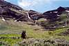
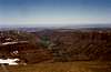
Hike into the South Steens Campground and go past a large group campsite parking area. Will come to a gate with a sign-in sheet and postings from rangers (warning of rattlesnakes etc.). Continue hiking on an old Jeep road till the first river crossing (no bridge, it's knee deep and about 30 feet wide). At this point, the 'road' turns into a trail. You'll cross the river/stream two more times within a mile (don't bother removing your Tevas). Continue on the trail as it enters the Big Indian Gorge. As the trail turns east (following the turn in the gorge), you'll see a "wall' in the distance - what appears to be the end of the gorge. This is your goal. The highest point you see on this "wall" ahead is not the summit of Steens though (true summit lies to the south or your right of this highest visible point). As you approach the wall, the trail disappears in a meadow and the going is x-country from there on - can't mess up, just stay on the left bank of the main stream in the Gorge and keep heading towards Steens. Near this apparent end of the gorge, you'll see that the gorge actually turns south (right). Make that turn staying on the left bank of the main stream. Ahead of you (to the south) lies a scramble. Aim for what appears to be an eroded rock pinnacle at the center but turn left directly below it and continue going up. Your destination will become clearer as you climb. You'll come up to a nice basin with an obvious saddle visible to the south - go up it. From the saddle you'll see a small lake (Little Wild Horse Lk.). Turn left and climb up the rock ridge. Once on top, you'll get your fist glimpse of the radio-antenae-clad true summit of Steens and Wild Horse Lake. Traverse top of this ridge till you hit the dirt summit road (open to cars when snow-free).
Descend either same way, via the road (probably the fastest and safe if you're running out of daylight), or via Little Blitzen Gorge (D. Lorain's recommendation). The road is quite scenic, but the cars and esp. the resulting dust clouds at lower elevations take away from the beauty of the hike.
 |  |  |  |  |
Essential Gear
Hiking boots and possibly some footwear to cross the streams.
Hiking poles recommended and in early season an ice ax might come in handy for making your way out of the Big Indian Gorge. There's plenty of water all throughout the gorge but none (if there's no more snow) once you climb out of it.
Miscellaneous Info
If you have information about this route that doesn't pertain to any of the other sections, please add it here.