

-
 20257 Hits
-
 90.13% Score
-
 31 Votes
|
|
Custom Object |
|---|---|
|
|
45.84411°N / 6.92413°E |
|
|
Custom Object |
wait please
still in progress, more sections will be addedthe BIG routes
The ones who have climbed a big mixed wall perfectly know that the route cannot be described with precision: there where snow, ice, seracs, crevasses are part of the route, routefinding is only a matter of experience : climbers must be fit and skilled enough to go past the surprises that the changes of the seasons or of the weather can put on the route and, of course, be able to climb classical difficulties (even the strongest) wearing the crampons.Which are the features that a route must have to be a BIG route (in the Alps) ?
The only needed info to climb them, as for we are concerned, are :
So we are going to put here these (we think useful) small info about the main routes.
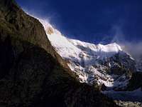
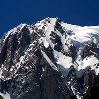
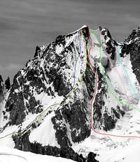
Brenva wall - the classic routes
The Brenva wall is the Eastern wall of Mont Blanc.Its average slant is about
- 40° northern border (Brenva Spur)
- 45° northern side (Sentinel)
- 50° central side (Major)
- 55° left side (Poire)
- 65°+ southern border (Pilier d'Angle)
so not too much steep, but this is on a wall that has a difference in elevation between 1300m (Sentinel) and 1600m (Pilier d'Angle)
 | On Brenva wall, in the years from 1927 to 1933 Thomas Graham Brown (a great British climber) created the famous triptych of the Brenva : 1927 - The Sentinel aka Red Sentinel or Right Sentinel - with F.S.Smythe in 2 days 1928 - The Major aka Left Sentinel - with F.S.Smythe in 2 days 1933 - The Poire with Alexander Graven and Alfred Aufdenblatten in 1 day these were the first routes opened on the walls of Mont Blanc : till that time Mont Blanc was only climbed along its (safer) ridges. After those exploites the wall became (and is still now) a goal for the best mountaneers : the most climbed (and maybe the BEST) is the Major Some more routes were opened later, all more difficult and dangerous. |
 the Brenva Spur the Brenva Spurfrom Purtud (Val Veni) |  the routes on the Brenva wall the routes on the Brenva walltelephoto from the valley | 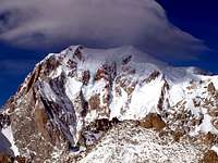 the Major on the Brenva wall the Major on the Brenva wallfrom Punta Helbronner | 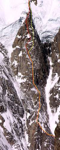 the Poire on the Brenva wall the Poire on the Brenva wallfrom Punta Helbronner |
From the Fourche you have to cross, along the route to Col Moore (usual starting point for the Brenva Spur) the Brenva plateau, get the Col Moore (3479m), cross it and follow on ascending toward left, in a not difficult environment, till the foot of the Sentinella Rossa (Big red rocky spur with a good bivouac site at about 3800m).
Now, crossing to the left and after a channel you get the "Costa Mummery", cross another channel to get the snow ridge dividing this channel from the big (Killer) central channel
Here you can make the first choice :
Here you can make the second choice :
Once the choice has been done you must follow, as pointed out by the sketches, using the safer route you find; for the Major the best choice is to stay always on or very near the edge, at the end of the big snow ridge there should be an easier way out on the right part, but the sequence of channels and dihedrals on the left part is safer.
Peuterey ridge
the finest route to Mont Blanc a real stairway to heavento be approached ONLY when weather conditions are absolutely good !!! once near the Col de Peuterey the escape is the M.Blanc summit
 | Yes, the Peuterey ridge is also the safest route for coming down having climbed the Aiguille Blanche or the Pilier d'Angle (it's not a joke, coming back to the valley from the Col de Peuterey is normally more difficult and much more dangerous than going to M.Blanc summit). In a fine weather day, not too windy, the ridge has classic difficulties on normally good snow, the only requirements are to be very very fit and trained; from the Col de Peuterey only the first stretch (up to get the snow ridge after the Pilier d'Angle) has some difficulties and some (small) danger. The marked route is the finest, the Pilier can be passed over on the left side (Freney) along a system of snow ledges and short rock steps, but it is a little less safer. The big gendarme after the Pilier d'Angle must be passed over on Freney side (W) |
The only problem is how to get this point: there are many different solutions (all requiring to be a good mountaneer) :
Once at the summit of the Pilier d'Angle (there where the Peuterey ridge changes its direction) only 500 metres to the summit of Mont Blanc (3-5 hours)
 the Aiguille Blanche routes the Aiguille Blanche routes |  the Pilier d'Angle routes the Pilier d'Angle routes |  Peuterey ridge from the upper end close to Mont Blanc summit Peuterey ridge from the upper end close to Mont Blanc summit |
Mont Blanc South side
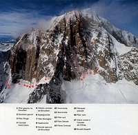 | the whole range, from Brouillard to Peuterey ridge, is a sequence of big routes. Some became classic like the "Innominata" (the "easier") and the "Central Pillar" (the most famous,maybe due to the tragedy during an attempt) and so, often climbed. Some are really a gamble (like the Hypercolouir, the Hypergoulotte, the "Abominette" and the Gran Colouir du Freney) because can be climbed only in particular conditions of the mountain. One, that could become really "classic" (the Gervasutti on the North Pillar) has been forgotten. No info about the other ones that maybe have been only "exploits" but I think that are really very challenging. |
Grandes Jorasses
all the routes to Grandes Jorasses must be considered bigThe easiest route, the normal one from Rifugio Boccalatte, is as engaging as the Brenva Spur to Mont Blanc.
The traverse from Col des Grandes Jorasses to Punta Walker (West ridge) is the only route that can be climbed (with absolutely safe weather) by "normal" climbers, all the other ones leading to the main summit ridge are very strong and difficult and require very good rock climbing skill and a very high training and fit.
 | Apart all the routes on the N side, all very engaging and difficult (some also very dangerous) there are 2 more "classic" routes, not so often climbed (almost neglected), that are very worth : |
For details see the Route section ot the Grandes Jorasses page