
-
 18371 Hits
-
 74.01% Score
-
 4 Votes
|
|
Route |
|---|---|
|
|
40.52670°N / 111.7553°W |
|
|
Steep Snow |
|
|
Most of a day |
|
|
Class 3 |
|
|
Approach
Driving south on Wasatch Boulevard: Continue south past the mouth of Little Cottonwood Canyon for miles past the 4-way stop on the south side of the canyon. Turn left onto Rainbow Oaks Circle, which ends between an LDS Church to the north and Hidden Valley Park to the south. Park here and begin hiking down the dirt road.
 |
Route Description
From the church parking lot, walk up a dirt road as it switchbacks toward tha mouth of Big Willow Canyon. Right as you enter the canyon there will be a small but well defined trail that branches off the road to the right. Follow this steep trail as it cuts south through scrub oak across the western slopes of the Lone Peak Massif. Eventually the trail turns up Littlle Willow Canyon. Make sure to take the switchback at the 'avalanche danger' sign farther up the canyon.
The trail climbs over a ridge and drops into Big Willow, traversing along the heavily forested south side of the canyon until the trail reaches the canyon bottom. From here, the trail winds its way through pine forests and meadows as the base of huge granite cliffs to the north. Eventualy a headwall is reached, which can be bypassed by scrambling up the slopes to the north. From here, continue hiking along the canyon bottom until the cirque is reached near treeline.
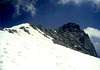
Cut south across the open cirque and continue up the steep headwall. Follow just to the right of a prominent arete that cuts 1/3 of the way down the slope. There is some airy class 3 scrambling on large solid blocks for the last hundred feet. There are some losse boulders sitting around, so use caution. Once the top of the cirque is reached, just walk across the plateau to the highpoint to the southeast - this is where the knife-edge ridgeline to the summit begins. Follow the exposed class 2-3 ridgeline south to the summit.
 |  |
Essential Gear
Make sure to bring your 10 Essentials, as well as a helmet, crampons, an ice axe, and possibly snowshoes and avy beacon depending on time of year.
While it is possible to do this route in the summer, the open slope in the cirque would have lots of miserable rock, so this route is best done when covered in snow. It makes a great May-June snow climb, since the avalanche danger usually low and the snow is hard-packed by then.
 |  |
Miscellaneous Info
If you have information about this route that doesn't pertain to any of the other sections, please add it here.
rmjwinters - Oct 16, 2009 1:45 pm - Hasn't voted
Sawmill TrailRecently a sign for Sawmill Trail has been placed at the mouth of Big Willow Canyon at the beginning of Sawmill Trail. The elevation of the sign is at about 5,500 feet about 100 yards past the junction with the Bonneville Shoreline Trail.