
-
 10244 Hits
-
 76.66% Score
-
 7 Votes
|
|
Route |
|---|---|
|
|
45.22650°N / 116.558°W |
|
|
Hiking |
|
|
Summer |
|
|
Most of a day |
|
|
Class 3 |
|
|
Getting There

Hornet Creek Road is paved and is easy driving. Follow it for about 28 miles to where the pavement ends and the little settlement of Bear is located. There is a little white painted one room school house along the road in Bear and note your mileage here. The gravel road is good and continues up the valley beyond Bear for another 4.3 miles before you turn left on FR 105 with a sign indicating that Black Lake is 15 miles ahead. The trailhead is at Black Lake.
FR 105 is rougher and it starts to climb at 5.1 miles stay left and pass the work center. At 6.0 miles you crest a ridge and there is a historical marker on the left for some old mail cabin that doesn’t exist anymore. Turn hard right here and proceed onto FR 112. There is a sign here that the road is not recommended for passenger cars. If you are driving your wife’s BMW, turn around and go get your old beater car that you use for going to the dump. This road has some rocks in it and high clearance will be an advantage. I’ve seen some SPer’s get their cars up 4WD goat tracks before and this road isn’t that bad. Of course if it is still wet and muddy from the spring thaw, you will have problems. Stay on this road, past the Placer Basin Historical Marker at 8.4 miles, and past the turn off for Smith Lookout at 11.0 miles.
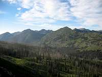
At 12.0 miles you come over a saddle at about 7,400 ft elevation and you can see some mountains off to your front left. That is your destination. Continue and at 16.7 stay left to the lake. The lake is at mile 18.0 from the Bear school. Just past the large Black Lake Campground/Hells Canyon Recreation Area sign is the trailhead on your right. This is where you start your hike, elevation 7,220 ft. There isn’t any parking at the trailhead so go back down the road about 100 yards and turn off to the south and find a place to park.
Route Description

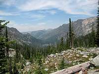
From the trailhead at Black Lake follow the trail up to Purgatory Saddle (7,940 ft). The trail is good and easy to follow. Stay right at the trail junction just before the saddle and pass by the little unnamed lake near the saddle. From the saddle you can see Emerald Lake in the valley to the north. The trail makes several switchbacks down the north side of Purgatory Saddle and then heads up the valley to Emerald Lake. Follow the trail and enjoy the scenery. Pass by Emerald Lake and the little unnamed lake to the north of Emerald Lake.

Stay on the trail until you get to elevation 6,600 ft about a mile north of Emerald Lake. The area here is forested but you can occasionally see to the east an impressive vertical face of the mountain that runs parallel to the Emerald Lake Valley. You may even be able to see a break in the continuous wall. In any case at 6,600 ft in elevation turn right, leave the trail and head east.

There is a live creek coming out of the basin that you want to access. I recommend you can follow this creek up on the south side in the forest about 200 ft from the creek until you get close to the vertical face of the mountain. Then cross over the creek which is very brushy and continue on the north side of the creek up into the basin. This is a long climb with no trail. Stay out of the brushy creek and parallel the creek either on the north or south side. The entry to the basin is at least a 100 yds wide, so if you follow the wrong creek and get pinched in with vertical walls on both sides, you are following the wrong creek.

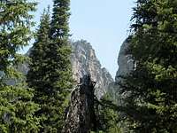
Climb the 1,000 vertical feet up to the basin and then the steepness of the terrain becomes less intense and the bottom of the basin is rocky with mostly good footing. When first entering the basin, you should be intimidated by the vertical walls ahead and to the right. Continue into the basin until you can see the north end and Monument Peak rising prominently. It is triangular in shape and looks like the tallest thing on the surrounding cliffs.
Walk up the basin directly at Monument Peak through steep wooded slopes and some minor cliff bands.. You need to gain about another 1,000 ft in elevation before you come to the base of the cliff that leads to Monument Peak. To the left of the summit there are several chutes in the cliff bands that lead up to the north ridge of Monument Peak. I went up the first chute next to Monument Peak. I’ve heard the second chute is easier to climb. Climbing the first chute to the north ridge is class 3 scrambling for about 225 ft. You will need to use your hands and find placements for you hands and feet. There is a cave about half way up that I passed by going left and then across the roof of the cave back to the right side. There is lots of loose scree and rocks in this chute and if someone is below you, they probably should wait until you reach the ridge above.
Once you reach the ridge, it doesn’t look like easy climbing up to the summit. Don’t go straight up the ridge. Instead, follow the boot trail off to the east a little and pass around to the east side of the ridge. It is an easy scramble up to the summit from the east side.
Return to the trailhead by the same route. Save some energy for the hike back. Once you are back on the trail you have about 2.7 miles of uphill to Purgatory Saddle and gain about 1,300ft.
Stats: Round Trip is about 11.2 miles with about 4,300 feet of elevation gain. It took me 8.25 hours for the hike.
Essential Gear
