

Comments
No comments posted yet.
|
|
Trip Report |
|---|---|
|
|
34.75589°N / 32.41081°E |
|
|
Nov 6, 2019 |
|
|
Hiking |
|
|
Spring, Fall |
The sunlight reflected off the silver-blue sea as our plane started to descend. I had been watching the view change from the cold, grey and greens of early winter in England to the bright sunshine of the Mediterranean countries. Islands and coastlines had passed beneath us, bathed in warmth whilst the green fields had been replaced by the sandy orange and brown hues of sunburnt lands.
I had just retired from work and November in England – as far as the weather was concerned – was decidedly gloomy.
Paphos in the south west of Cyprus is generally known as a summer holiday destination, full of sun, sea and cut-price booze with this area being particularly popular with the British. Not really a mountaineering destination but with temperatures in November being in the high twenties centigrade and less crowds than the summer, it is a very pleasant change from the UK and from a hiking point of view, there is plenty to do.
Most guidebooks and commentators advise that the best way to get around is to hire a car. We didn’t want the extra expense and the hassle of trying to park, so opted to use public transport.
It has been recorded elsewhere on SP that there are no good maps available for Cyprus. We made do with the maps provided in the guidebooks we used.
We spent a few days doing some of the shorter walks along the coast and visiting some of the fantastic archaeological sites around Paphos and Coral bay as well as getting used to travelling around on the public transport system.
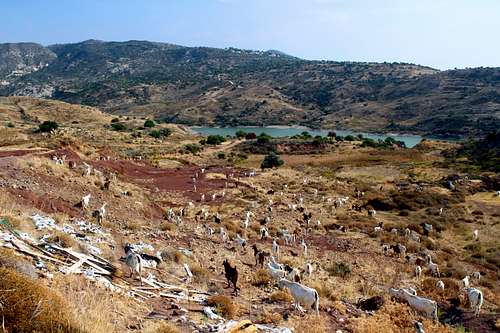
We also had a day inland on a walk that took us through banana plantations to the Mavrokolymbos reservoir. Here we climbed up to a knoll to catch what little breeze there was and later encountered a multitude of goats and sheep.
On our second day, we had returned to our hotel for a beer on our balcony whilst watching the sun go down.
“Do you realise?” Marie said, checking her watch. “This time last week, you were leaving work for the last time?”
I hadn’t realised – already, it seemed that had happened a long time ago.
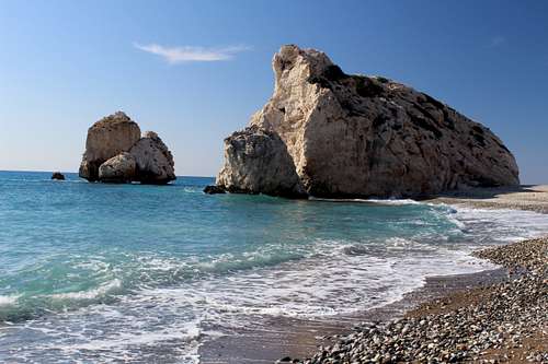
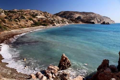
(Reputed to be the birthplace of the goddess of love, Aphrodite.)
(Hike - Approx 16 Km)
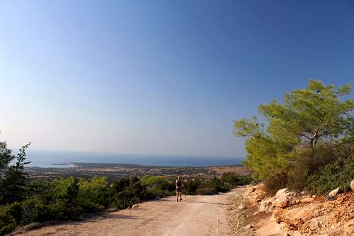
Although Petra tou Romiou looks only a short distance south eastward from Paphos, the bus journey wound its way through small towns and took nearly an hour. When we all got off the bus, everyone headed into either the small shop by the car park or down towards the beach.
Marie and I followed our guidebook route description and headed upwards onto the cliffs. The nature trail was set out with signs telling us what each of the plants along the way were.
“Spiny Burnet”. I read one of the signs next to a small bush covered with vicious looking thorns. “Sounds like an east London gangster!” I said.
Sadly, a lot of the plants were burnt to dried out twigs. The temperature in November was in the high twenties centigrade, but nothing to what it would have been in summer.
We reached a seat with a wooden shade on a viewpoint overlooking the sea and the beach where the birthplace rocks are situated. We caught whatever breeze there was and admired the view up and down the coast. The sea disappeared over the horizon but was calm as a small lake on that day.
We headed away from the sea and upwards, following a track towards what we could see of the A6 road to Limassol.
Away from the cliff, it was hotter but we made good time.
“I think we’ve gone a bit wrong”. I said checking the guide again. “We don’t go this near to the road.”
Sure enough, we were on the wrong track and had to descend until we spotted our trail.
We crossed a small valley to another track that took us back to the cliff tops a little further westward. After admiring the views again, we continued on a descending path to cross the B6 coast road.
The trail is signposted here to continue along the road for a short distance before continuing towards the sea and the cliffs above the pebble beach.
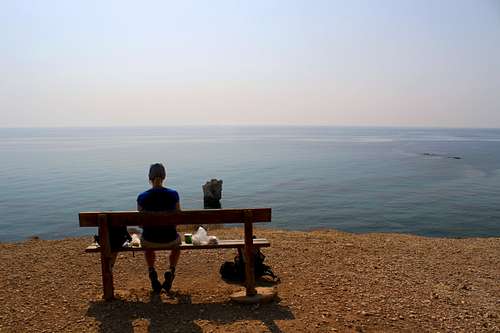
The crowds stayed around the rocks, 5 minutes from the carpark/bus stop and the further we got away from here, the fewer people we saw. Regularly spaced benches by the path meant the walk took a lot longer than it should have!
We sat and had a bite to eat on a clifftop bench.
“I wonder what the weather’s like back in the UK?” I said.
“Not as hot as this, that’s for sure.” Marie replied. “And no views as good as this.”
She continued, “Do you remember that Beautiful South song, “The Mediterranean”? I can’t help think of it looking out at that sea.”
I recognized the tune when she sang it and the last line of the chorus but hadn’t realised the song was about the Mediterranean Sea. Marie grew up on the west coast of Ireland so has an affinity with the sea. That song became the theme of the whole trip, repeated every time we saw a fabulous view over the “Med”.
The trail continued to a picnic area, just off the road and had a way down to the beach here. We descended and decided to continue along the seashore, this was harder going as the shingle gave way under out feet.
Eventually, we reached a spot where the cliffside path descended to the beach and we could head back. So far, we had taken 3.30 hours and now had to get back, so we set off along the cliff top nature trail.
Now we were in a hurry so didn’t stop so many times and returned in 2 hours. The views across the sea were still amazing.
The Akamas peninsula lies at the western most point of the island. The area has some very fine walking and we had three visits there during our trip. Two of the best official nature trails are the “Aphrodite” and “Adonis” trails. The first walk we did here was an amalgamation of these two.
(Hike - Approx 16 km)
It took three separate buses and about 2 hours to get to our destination.
Paphos harbour – Paphos Karavella
Paphos Karavella – Polis
Polis – Baths of Aphrodite
The “Baths of Aphrodite” is a botanical garden with a (rather gloomy) natural pool that was said to be frequented by the goddess of love. A restaurant, car park, small shop and a few houses complete the facilities. Both the nature trails start from here.
We set out on the Adonis trail and headed southwards, back down the main road towards Polis. This is against most official advice which told us to head northwest up the Aphrodite trail but I had read this was a good way to do it and it was certainly a quieter alternative. We continued down the road until a signpost showed us the obvious way up. From here, the trail went up quite quickly and provided us with views of our starting point and the north coast of the island. The trail was easy to follow and as we rose higher, the trees became more stunted and wider spaced giving us further views along the north coast.
As usual, the undergrowth abounds with Lizards – some of them quite large – but all very shy.
Having crested a small hill, we descended slightly on a rocky path into a valley. Although there was no running water, it was clear that this area contained more vegetation including Cypriot Cyclamen which sprouted from rocky outcrops.
Soon we reached the Kefalovrisia spring, characterized by a number of tall Calabrian pines.
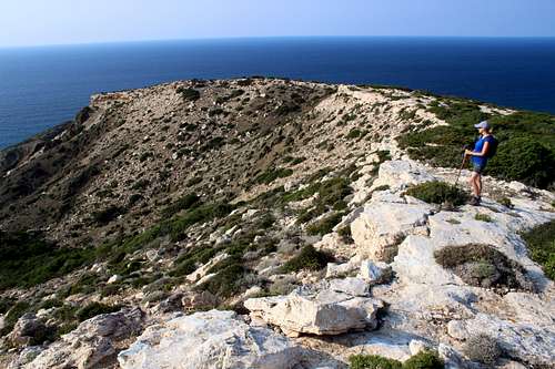
There are several trails here but the Adonis trail is marked and heads to the right (north) and uphill to the high point of the ridge at 335m.
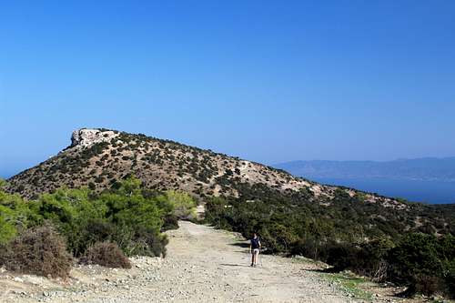
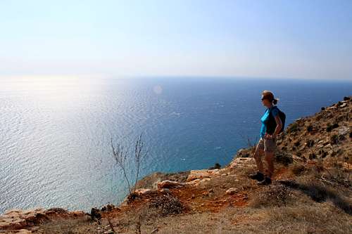
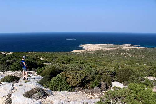
Now, we were back in the sunshine and headed up to a viewpoint. From here, we could see the summit of Moutti tis Sotiras our highpoint for the day and southwards down the west coast of the peninsula.
“What’s that island we can see?” Marie pointed to a round, flat looking island further down the coast.
With no map to help me, I didn’t know but later in the trip, I realised we were looking all the way down towards Agios Georgios and seeing the island of Geronisos, just off the coast.
We returned to our wider track and met the first of the 4wd vehicles. Up to that point, we had met one man on foot but the bigger tracks are used by local farmers, tourists and off road enthusiasts (even though this is a nature park!) - one of the down sides to the area.
We could also see a lot more people walking up the Aphrodite trail, this is obviously the most popular trail and we were pleased to have chosen the quieter route.
We followed the Adonis trail down until it joined the Aphrodite trail and then rose up again towards the top of Moutti tis Sotiras (370m).
The view from the top is amazing, stretching to the northwest across the peninsula and along the north Cyprus coast. We stopped for some food and to take in the views for a while before the arrival of more people made us choose to continue on our route.
Now on the Aphrodite trail, we descended the trail on the western, quieter side of the mountain, on our own. The path here is narrower and steeper but although not difficult, seemed too much for most of the visitors. I continued to take photos as we descended, only to realise later, they are all of the same view!
The trail turned back towards the sea as we rounded the mountain and joined the trail out towards Cape Arnaoutis at the head of the peninsula. We however, headed back towards our starting point and the bus journey back to Paphos.
(Hike - Approx 24 Km)
An early start got us to the harbour bus terminal at 8.30 am for the bus to Coral bay. Here, we waited for the small minibus to Agios Georgios (St George) and asked the driver to let us off at the turn off for the southern end of the Akamas peninsula road.
The road heads northwards towards Lara beach, a Sea Turtle sanctuary during the summer.
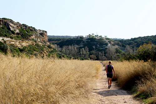
30 minutes walking down the road bought us to a carpark and we left the road and turned right and inland to cross a field of long grass towards the gorge entrance.
As soon as we left the coast, we lost the sea breeze and it got hotter, so we stopped for a drink.
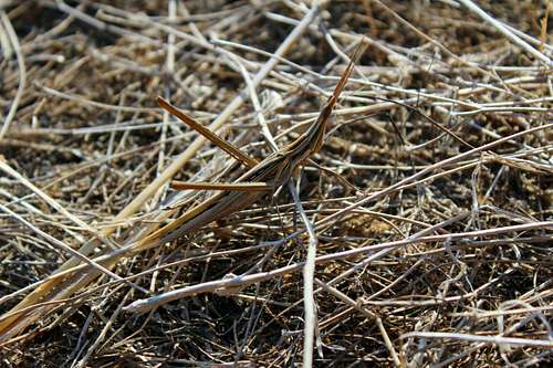
A movement on the path caught my eye – but I could only see pine needles and dead grass. I shifted my feet and the “pine needles” hopped a short distance! Clearly, these are not just any old “pine needles!”
“What are you doing?” Marie asked as I dropped to my knees, camera in hand.
“There’s something here.” I replied. “An insect of some sort.”
“Where, I can’t see it.” Marie bent over to look and her movement caused the Alien – like creature to hop again. She gasped in surprise, “What is it?”
I had no idea. I had never seen anything like it in real life or on tv. Later, I found out that it is a Cone-headed Grasshopper (Acrida Ungarica) and apparently, quite common!
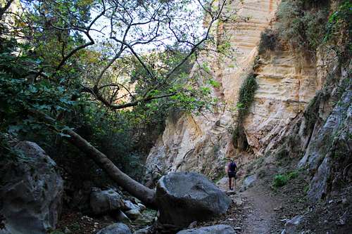
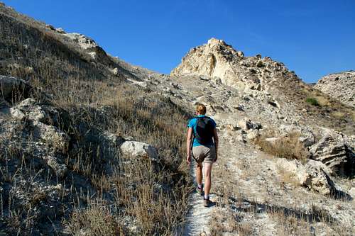
We continued on and into the gorge itself. It’s quite steep sided and it’s apparent, we will not be alone! We tried to get ahead of some of the parties but I wondered if this was a fruitless task. The gorge narrows until we could almost touch both sides and a stream now covered most of the bottom of the gorge. There was some scrambling over wet rocks in the gloomy half-light and this seemed to deter quite a few visitors from going any further.
The trail jumped from one side of the stream to the other as the gorge opened out again. For a while, it was nice and cool in the shade of the walls or the trees growing alongside the water. We saw bright red Dragon flies and lots of Butterflies as well as a group of English birdwatchers on the lookout for an elusive Wallcreeper, a bird wintering on Cyprus.
The further we went, the fewer people were seen. At the end of the gorge, we found a bench perfectly situated for lunch.
Most gorge travelers seemed to return the way they had come but we wanted to exit the gorge and do a loop around and back to the coast. It looked straight forward on the map in our guidebook although, the notes did say that the way was unmarked and that route finding needed a lot of attention.
We set out across the sunburnt landscape in the early afternoon. At first, all went well but when we got to a possible left turn, we couldn’t believe it was the correct turn.
Needless to say, it was the turn we wanted and we went the other way!
We continued on, still unsure of the route until our track reached a junction with a larger dirt track at an information board, this was not mentioned in our guide.
Note for anyone doing this route: If you see the Information board, you have gone the wrong way!
We turned left to try to get back to the track we wanted but after about 10 more minutes, it was clear we were getting further away. We climbed a small hill to survey the scene.
We had travelled in a big U shaped direction and were now looking down on where we should be but only about 500m away. A little farther on there was a side track which looked to head in the right direction.
“Shall we just go back the way we came and pick it up or shall we try that track over there?” I pointed to the track.
“I don’t fancy going all the way back.” Marie.
Now, everyone knows that when you have no map and are off route, heading off on an unknown track is always a good idea!
For a while the track looked like it would bring us back to our route… but then it just ran out. We were really near where we wanted to be with just a shallow stream and loads of undergrowth in the way.
Suddenly, a local man appeared from nowhere. I assumed he was a farmer and we were probably trespassing. I would have suggested hiding but it was too late for that!
“Hi there!” He waved to us, no order to get off his land!
“Can we get across the river there?” I asked tentatively, pointing to where he was.
“I’m sure you can.” He replied.
We had a bit of a chat, he wasn’t a local landowner and didn’t say what he was doing - we wondered if he was illegally hunting - but 10 minutes later, we had negotiated rocks and thorny bushes and were across the stream and back on our route.
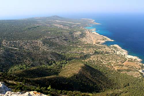
We passed a barking dog at a goat farm and several deserted buildings and met another dirt track – according to the guidebook it runs from Kato Arodes to Lara beach. We turned left and headed upwards, looking down onto where the gorge path exits the gorge itself. The track climbed through the rocks and deserted farms up to a high point where we crossed over the ridge to the seaward side and the Pegeia forest.
It’s possible to see the island of Geronisos, just off the coast of Agios Georgios, our final destination but the route through the forest heads away in the opposite direction. There was nothing else to do but follow the track under clear blue skies, down towards the sea.
About an hour later we reached the main coastal track near Lara beach and headed back along the road towards Agios Georgios.
Another hour later, we were back at the church of Agios Georgios and luckily the bar next door was still open. We enjoyed a well-earned beer and crisps whilst waiting for the last bus and sat admiring the sunset.
(Hike - Approx 20 km)
Almost a week after our first visit, we retraced our bus journey to the Baths of Aphrodite to walk out onto the end of the peninsula.
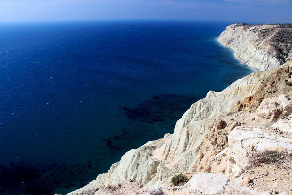
We had to follow the 4wd track for a lot of the way but we saw only a few during the whole day. The trail threads it’s way between clumps of Gorse bush, low growing Cyprus trees and some Junipers. However, the sharp outcrops of rock and even sharper thorn bushes mean that there is no way to leave the track.
We got to a bay known as the “Blue Lagoon”.
“Look at the sea, all of those beautiful shades of blue.” Marie was correct, the sunshine caught the waves and created a multitude of different shades.
We were enjoying our day. We had originally decided to just walk out and back but now decided to make it a bigger walk. This meant missing our early bus and the vagaries of the timetable would mean a late finish unless we could get a taxi back to Polis, we decided to continue anyway.
We reached the end of the lonely peninsula, only to find a fisherman on the beach, we stayed on the low cliff and stopped to eat our lunch. Afterwards, we visited several sites, unsure of which one is the actual end of the cape before deciding to head back.
|
|
Our route returned to the Fontana Amorosa (Fountain of Love) before joining the E4 long distance footpath and headed upwards towards the summit of Moutis tis Sotiras again.
By now, we were tired and virtually out of water and the upwards trail became a bit of a trial! Finally after a long and tiring ascent, we reached the familiar “Adonis trail” and descended the other side to join the “Aphrodite trail” beneath Moutis tis Sotiras.
Descending this, Marie was in front of me when I heard a rustle in the undergrowth to my left.
“Look Marie.” I shouted.
A long black snake disappeared into the rocks under a tree. It was too quick for me to take it in and it amazes me how quick these reptiles can move!
We got back to the bus stop and rang for a taxi.
15 Euros got us back to Polisin plenty of time for the next bus and in time for a beer and toastie in a bar whilst watching the Scotland football team beat Cyprus 2-1 on the tv. We had wondered why Paphos had been full of kilted Scotsmen – even though the game was in Nicosia!
(Hike - Approx 14.5 Km)
The bus to Pissouri Bay left the Karavella bus terminal in the centre of Paphos at 9.30 am. The small minibus had only 3 of us as passengers and with no need to stop to pick up along the way, we reached our destination within an hour.
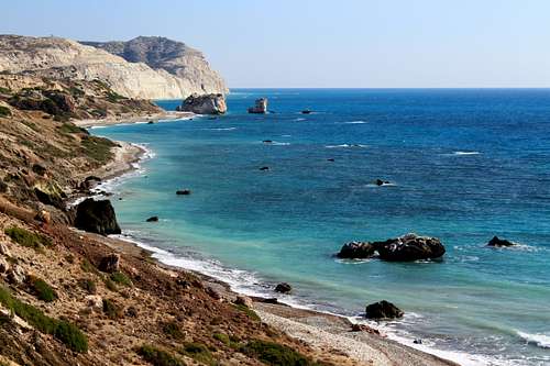
The weather was still lovely and sunny but now had a fresh wind blowing from the sea to keep us cool. We started along the promenade towards the cliffs at the western end of the bay and noticed straight away that the route was popular. There was a couple ahead of us and another not far behind.
Our route description told us that the beginning part of the trail had 3 narrow, precipitous sections and sure enough, the woman from the couple in front of us turned around at the first of these to return to the town. The path was narrow with a big drop off but nothing to deter us and the next two sections were similar but not as narrow.
The trail traversed around the headland with great view back towards the town of Pissouri Bay and then dropped towards a stony beach.
Marie and I followed the man in front of us down some rocks into a small valley followed by the two lads behind us who had caught up. The lads seemed to struggle on the rock and were contemplating its descent as we scrambled up the other side. From here, the trail heads up a rough path to the first viewpoint over the chalky cliffs with strangely eroded rocks along the way. The man in front of us seemed to change gear and in a few minutes was way ahead, the lads behind us didn’t follow and so very quickly, we were alone.
The trail followed a good path although, there were plenty of thorny bushes to scratch us and a few Olive trees as the path headed inland for a short way.
Soon, the path returned to the cliffs and another viewpoint by a broken-down goat enclosure and continued between the goats and the sea to gain the Trachonas plateau.
On top of the plateau and set back from the cliffs is a military installation, along the track was a jeep with a man in green army camouflage fatigues, he appeared to be waiting for us. His dogs ran around about the jeep.
“Hello, how are you today?” he asked as we approached.
We chatted and it turned out he was just waiting for friends and he was keen to find out about us and tell us about his English mother! From here, the track continued near to the cliff edge and we were preoccupied with the fabulous views over the sea once again.
On this day, the sea was deep blue with plenty of “white horses” on the top of the waves, blown up by the wind. About 15 minutes and a dozen photographs later, we reached the western end of the plateau and stopped to admire the fantastic sights further west along the cliffs and have some lunch.
The plateau lies at 210m but it’s possible to drop down to a secluded, stony beach.
We had just about decided against making the descent when Marie noticed something.
“Is that someone coming up?” she pointed down the cliffs.
The man who had left us behind earlier was returning up and back towards us.
“It’s a lovely day,” he said in English with a hint of a Germanic accent.
We agreed, it seems he had raced down to the beach, had a quick swim and was on his way back to meet his wife. After a quick chat, he was gone and we returned to our sea views.
Soon, we decided to head back too, retracing our steps along the cliffs in the warm sunshine with time to get a beer before the solitary bus back to town.
Our last day, so we decided to revisit Aphodite’s birthplace again.
This time, we followed the crowd down towards the rocks for a beach side view. Marie made friends with a stray dog whilst I photographed the lovely turquoise sea, whipped up again by a fresh breeze.
Then, we re-traced our steps and followed the nature trail up onto the cliffs and down the coast. Looking further eastwards, I fancied I could see paths up to a viewpoint on the cliff top, a route that wasn’t in either of our guidebooks and maybe a future destination for us?
Walking across the sun-dried hillside I suddenly spotted a large Black Whip snake disappearing into the undergrowth. As it was our last day, we wanted to descend to check on our old friends, the big Lizards. They were in their usual spot and ran off when they saw us!
We continued along the trail on top of the cliffs between the road and the sea, to sit once again on the bench overlooking a solitary column of rock in the water.
We continued to the end of the trail and returned the same way, watching a kestrel hunting above the coastal trees and bushes enjoying for the last time, our views out over the blue Mediterranean Sea.