
-
 21557 Hits
-
 85.87% Score
-
 21 Votes
|
|
Area/Range |
|---|---|
|
|
42.61417°N / 20.10167°E |
|
|
Hiking, Mountaineering, Skiing |
|
|
Spring, Summer, Fall, Winter |
|
|
8310 ft / 2533 m |
|
|
Overview
IntroRead as: [Bogitchevitza]
Bogićevica is a mountain area, and a morphological unit in eastern part of Prokletije (Bjeshket e nemuna/Bjeshkët e Alpeve Shqiptare) range, situated between Treskavička rijeka (Treskavac river) on the west and the source and upper flow of Dečanska Bistrica river (Lumbardhi i Deçanit/Lumebardhi i Deçanit/Bistricës (Lumbardhit) të Deçanit) on the east. Bogićevica spreads over three countries: Montenegro, Kosovo/Kosova (Wiki: a disputed territory in the Balkans. The partially-recognized Republic of Kosovo (Albanian: Republika e Kosovës), a self-declared independent state, has de facto control over most of the territory, with limited control in North Kosovo. Serbia does not recognize the secession of Kosovo and considers it a United Nations-governed entity within its sovereign territory, the Autonomous Province of Kosovo and Metohija), and Albania. The mountain area is roughly 15 kilometers long (in E-W direction) and 10 kilometer wide (in N-S direction).
There are more peaks higher than 2,000 meters in Bogićevica, two of them even higher than 2,500 m: Marijaš (Bogdaš) (at 2,533 m the highest peak of Bogićevica) and Maja Rops (2,502 m).
  |
Borders of the Area
Starting counter-clockwise from its north-western edge, natural borders of this mountain area are following: Treskavička rijeka (river) - katun Bjelaj (katun is periodical, summer shepherd´s settlement) - Ćafa Bjelaj (ćafa=qafa is a mountain pass, originally Albanian word but used by all nations in the area) - Lumi Proni Gašit/Lumi i Gashit river valley in Albania - katun Dobrodol (Dobërdol) - Ćafa Dobrodol (2,275 m) - Bistricës te Kozhnjerit river (Kožnjarska Bistrica, Lumi i Kozhnjerit) - Bistricës te Deçanit river (Dečanska Bistrica, Lumbardhit te Deçanit) - katun Raški Dol - katun Zavoj - Babinopoljska rijeka (Babino Polje´s river) - Babino Polje (settlement) - Temnjačka Rijeka (Temska´s river) and back again, Treskavička rijeka river.
Mountain area of Bogićevica is separated from surrounding mountain areas by mountain passes and deep river valleys:
to SW with Ćafa Bjelaj mountain pass (1,965 m),
to SE (Đeravica/Gjeravica, Gerovica Junikut/Bjeshkët e Nemune te Junikut/Juničke planine and Skilzen/Shklezen/Maja Škeljcen group) with Ćafa Dobrodol, and to
North (Bjeshkët e Lumbardhit/Ljumbardske planine and Starac-Zavoj mountain area) by a mountain pass situated between mountain peaks Maja e Vogël (Vogelj 2,284 m) and Zavoj (2,243 m).
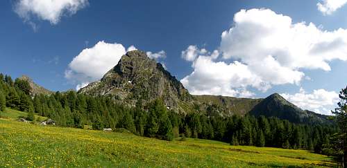
 eastern part of Bogićevica from Krš Bogićevica |
Morphology and Geology
Morphological Description
The highest central parts of Prokletije mountain range (Popluks,Karanfili-Brada, Bjelič-Bor groups) extend to the East in direction of other high mountain groups in eastern parts Prokletije, such are Đeravica/Gjeravica and Skilzen/Shklezen/Maja Škeljcen. When reaching those groups the main mountain ridges of Prokletije diverge to northern direction and spread over mountain areas of Bogićevica, Koprivnik/Maja e Kopranikut and Streočka pl./ Bjeshket e Strellcit and further across Bjeshkët e Lumbardhit/Ljumbardske planine mountains and Čakor/Qokorr mountain to the North-eastern part of Prokletije (where the highest mountain is Hajla (Area; Mountain, summit).
 and the area around Hridsko jezero (Hrid´s Lake) |
The main mountain ridge, the "backbone" of Bogićevica is actually the continuation of the main ridge of Prokletije mountain range; the one that is arriving from western parts of Bjelič group then follows Montenegrin-Albanian border and finally arrives to Bogićevica from south-western direction. In Bogićevica area, this ridge shortly turns to west-east direction until reaching Tromeđa peak (2,366 m, which is three-countries border point, between Montenegro, Albania and Kosovo), from where it turns again, this time in northern direction.
Main mountain ridge is broken by glacial, fluvial-glacial and fluvial-erosion processes, into more mountain sub-ridges branching off the main ridge. The main ridge is higher than 2,000 m in almost all of its length across Bogićevica area. Along the ridge itself, beside few lower laying mountain passes, there are more higher peaks as are: Pasji vrh (2,405 m), Maja Madhe (2,372 m), Maja e Vogël (2,284 m), Tromeđa (2,366 m), Maja e Spalit (2,203 m), Ujkov krš / Kërshi Vujkit (Vujkut) (2,269 m).
From Tromeđa peak one shorter sub-ridge branches off in SE direction in direction of Ćafa Dobrodol (2,275 m), a mountain pass that separates Bogićevica from Đeravica/Gjeravica and Skilzen/Shklezen/Maja Škeljcen mountain groups. Two higher peaks are situated along this sub-ridge: Maja Bogicaj (2,404 m) and Maja e Ram Arucit (2,358 m).
The mountain and its high peak Marijaš (Bogdaš) (2,533 m) is another such sub-ridge, connected to the main mountain ridge with its SW part. From northern side it is bordered by Dečanska Bistrica/Bistricës te Deçanit river source area and its course, and from southern side by deep valley of Beleški potok stream and its tributaries.
The mountain and its peak Maja Rops (2,501 m) is connected to the main mountain ridge with its western parts. To the north of Maja Rops is Beleški potok with its tributaries which flows here into Dečanska Bistrica river, while to the south is the upper flow of Kožnjarska Bistrica/Bistricës te Kozhnjerit river.
Bogićevica mountain, is the vastest part of Bogićevica mountain area. The mountain touches the main mountain ridge with its southern and south-eastern parts, on Ujkov krš / Kërshi Vujkit (Vujkut) peak – Tromeđa peak – so called "Double pass" (Ćafa Bogićes and Ćafa Belega passes) section, while is separated from eastern and north-eastern part ot the main ridge by long and wide glacial valley of Babinopoljska rijeka river
Bellow peaks and ridges there are more traces of glaciation. One clear example is long curved glacial valley where Babino polje settlement is situated, a product of once-upon time present long glacier thatt was spreading from higher mountains in Plav direction.
Table 1. Structure of the Mountain Group - Bogićevica
| Peak Name | Other Names | Height (m) | Position Lat/Lon | Photo |
| Marijaš (Bogdaš) | Marijash, Marjash, Bogdash | 2,533 m | 42.6141667° N 20.1016667° E |  |
| elevation 2286 | - | 2,286 m | ridge peak - adjoining Škat e Hajnave pass from NE | - |
| elevation 2324 | - | 2,324 m | ridge peak - adjoining Škat e Hajnave pass from NE | - |
| Rudin | - | 2,064 m | 42.6175° N 20.1211111° E | - |
| Bajrak | - | 2,020 m | 42.6072222° N 20.1286111° E | - |
| Pasji vrh | Maja e Qenit both pas and qen means a dog | 2,405 m (2,406 m) | 42.5983333° N 20.0777778° E |  |
| Pčelin krš / Maja Madhe | Maja e Male, Maja Made madhe means large in Albanian | 2,372 m | 42.5883333° N 20.085° E | - |
| Mali Pasji vrh / Maja e Vogelj | vogelj = vogël means small/lesser in Albanian | 2,284 m | 42.6047222° N 20.0738889° E | - |
| Maja Rops | Maja e Rops, Majae Rops, Maja Ropsit | 2,502 m (2,501 m) | 42.5741667° N 20.1083333° E |  |
| Kožnjar/Kozhnjeri (spur) | Kozhnjer, Mali Kozhnjer | 2,154 m | 42.5866667° N 20.1427778° E | - |
| Velika Kleka | Veliki Klek | 2,268 m | 42.5863889° N 20.1116667° E | - |
| elevation 2363 (W) | - | 2,363 m | - | - |
| elevation 2329 (N) | - | 2,329 m | - | - |
| 4.1. Krš Bogićevica | ||||
| Hridski krš (Veliki Hridski krš-Large H.k. and Mali Hridski krš-Leser H.k. | - | 2,358 m | - |  |
| SW Peak | - | 2,194 m | - |  |
| Krš Bogićevica | - | 2,374 m | 42.5722222° N 20.0527778° E |  |
| 4.2. Veliki Hrid | ||||
| Veliki Hrid | Veliki Hrid, Hrid veliki | 2,073 m (2,076 m) | - |  |
| elevation 2,038 m | - | 2,038 m | - | - |
| elevation 2,011 m | - | 2,011 m | - | - |
| 4.3. Mali Hrid | ||||
| Mali Hrid (Tepsijica) | Mali Hrid, Hrid mali | 2,092 m (2,076 m) | 42.5841667° N 20.0427778° E |  |
| elevation 2078 | - | 2,078 m | - | - |
| elevation 1988 | - | 1,988 m | - | - |
| 4.4. Other Southern and South-Eastern peaks | ||||
| Ujkov krš / Kërshi Vujukt | Kërshi Vujkit | 2,275 m | - |  |
| Maja e Špalit | Maja e Shpatit, Maja Spalit, Maja Spatit, Maja e Spalit, Maja e Špatit | 2,203 m (2,232 m) | 42.5591667° N 20.0561111° E |  |
| elevaton 2222 | - | 2,222 m | - | - |
| elevaton 2224 | - | 2,224 m | - | - |
| elevaton 2221 | - | 2,221 m | - | - |
| Tromeđa | Tromedja, Trokusit tromeđa means three-borders point | 2,366 m | 42.5561111° N 20.0777778° E |  |
| Ravno brdo (a ridge) | - | 2,205 m | 42.5638889° N 20.0808333° E | - |
| Maja Bogicaj | Maja e Bogiçaj | 2,404 m | 42.5505556° N 20.0883333° E | |
| Maja e Ram Arucit | Maja e Ram Arućit | 2,358 m | 42.5436111° N 20.0933333° E | |
Geological Structure
While central and western parts of Prokletije (like the most of the Dinaric Alps) are built of Triassic (251-199 million y.a.) and Creataceous (145-65 million y.a) limestones (sedimentary rocks, consisting mainly of calcium carbonates, usually the secretions, shells or skeletons of plants and animals) and in lesser extent of dolomites, the Eastern and North-Eastern parts of Prokletije, where Bogićevica is also situated, have forms characteristical for flysch (redeposited sedimentary rock) and slate rocks. This part of Prokletije, because of its eruptive structure (eruptive silicates – slates), has milder forms (especially comparing to steep vertical limestone towers of Central Prokletije), mountain masses are often rounded, easy passable and rich in surface waters.
But even in Bogićevica area there are more limestone belts passing through, and the one of the most prominent, runs in S-N direction, coming from Albania (Dobrodol) over parts of Bogićevica mountain to Pasji vrh and Marijaš (Bogdaš) peaks, and continues further north where some smaller parts of this limestone can be seen in Dečanska Bistrica river source area. Further north, following the same line, is clearly visible limestone massif of Bjeshkët e Lumbardhit/Ljumbardske planine mountain group.
 |
Hydrological Features
Bogićevica is rich in surface waters, thanks to the abundant precipitation and its geological structure. There are many sources, streams and fast mountain rivers, a picturesque Hridsko jezero (Hrid´s lake), many waterfalls and other hydrological features. All mountain area is cut up with deep valleys formed by strong rivers and strong erosion.
The divide between the Black Sea and the Adriatic watersheds passes over Bogićevica. Waters of western parts run in direction of Lim river, and further to the Black Sea, while those from the eastern Bogićevica run into Dečanska Bistrica then to Drim/Drin and the Adriatic sea. Southern flows run into Lumi Proni Gašit (river) and to Drim/Drin again.
The largest rivers flowing througf Bogićevica area are: Treskavička Rijeka (Treskavica´s river), Babinopoljska rijeka (Babino Polje´s river), Dečanska Bistrica/Bistricës te Deçanit, Kožnjarska Bistrica/Bistricës te Kozhnjerit, Lumi Proni i Gašit and Hridska Rijeka (Hrid´s river) flowing out of Hridsko jezero.
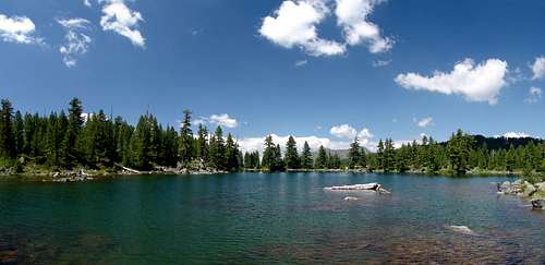
Hridsko jezero
This lake has become the symbol of Bogićevica and its largest tourist attraction. The lake is situated 18 km away from the town of Plav, at 1,970 m altitude, under rocks of Hridski krš (krš in this sense means craggy, rugged) and Veliki Hrid (veliki means large), and is sometimes less correctly also called Ridsko. The lake is one of the biggest mountain lakes in Montenegro (so called mountain eyes) an for many people one of the most beautifull lakes in the country.
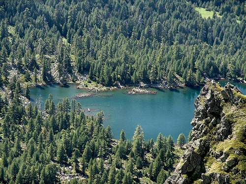 |
The lake today is clear example of well preserved glacial relief. In Pleistocene period (1.8-0.01 million y.a.) here was collecting area for ice that fell down over more steps from surrounding peaks, dragging with it heterogeneous material. Precipitatins had washed away smaller rocks, bur larger ones still remained on south-western and western lakeshore.
The lake is 295 meters long, 110 m wide and around 5 meters deep, in average. Beside precipitations it receives water from more sources located near its shores.
The lake is surrounded by nice molika pine tree (Pinus peuce Griseb.), which has adapted well to harsh local climate. This is a Tertiary (65-1,8 million y.a.) relict of Prokletije, the only 5-needle pine. It reaches a height of 25-30 m and a width of 1 m. It is often called a jewell of the Balkans and it grows in Montenegro, Kosovo, Macedonia, Albania; Bulgaria and to limited extend in northern Greece.
More tales are connected to Hridsko lake, and according to one of them even the name of Prokletije (proklet, means accursed) originates from here.
 |
Other Features
The sides of river valleys are covered with forests (forest areas: Bivoljak/Bivolijak, Hridska gora, Treskavica), and mountain ridges and mountain-tops are in mountain pastures zone (this is locally and also in science known as sùvāt zone (a word of Turkish origin means mountain pasture). On Bogićevica these are vast pastures easy passable, with more periodical summer settlements still active. Such settlement is usually called katun, or stanovi (a collection of more stans, houses, huts).
The most of higher mountain slopes and peaks in Bogićevica are treeless. Some slopes of some peaks can be very steep, but very often the access to this peaks are much easier if accessed over connected mountain ridges.
A part of Maja e Ropsit mountain has been declared a mountain flora reserve in 1955., covering the area of 25 Ha (molika, pine, beech), and in the same year Kozhnjari area (161 Ha) was declared a fauna reserve (Rezervat shtazor) especially because of the presence of chamois, (Rupicapra rupicapra L.). But today, after the latest war on Kosovo, and because of illegal hunting, it is questionable how many of mountain fauna has stil being preserved. There are some official intentions which brings more optimism in this issue. One of the ideas is forming of International Park Prokletije (see: External Link, section of this page).
There are no permanent settlements in Bogićevica, but many periodical shepherd´s settlements (Katuns), situated, in principle, somewhere on border between forest and pasture zones. Pastures on Montenegrin parts of Bogićevica are being used by shepherds from Upper Lim river area. Here, shepherds from the town of Plav and surrounding area ascended to pastures in Babino Polje, Treskavica and Tromeđa (Trokusit) areas. Katuns in this area are very dispersed, rarely there are tightly grouped together. The huts are made of woods mostly.
Mountain pastures on eastern parts of Bogićevica belong to Albanian shepherds from Kosovo. These pastures are less aboundant comparing to those oriented in Lim river direction.
There are no paved road in this mountain area, whilst more non-paved road exist and even leading to the highest parts, especially to the areas close to border where you can still see more military-border posts, usually a square-boxed low houses, today the most of them bandoned. There are some intentions to better connect the towns of Plav and Dečani/Decan and even to open a border crossing.
Climate
Bogićevica area belongs to European-continental and mountain type of climate, characterized in this region by short and rather fresh summers and long, cold and snowy winters. Spring periods are shorter, but the fall period can be longer and milder in temperatures.
In mountain areas the average temeperature is below freezing point (zero Centigrade) for at least 4 months in a year. Winter inversion is often in winter, especially during periods of winter high pressures, when mountains are bathing in sun while valleys and deep river valleys are much colder and under the fog, even for days.
Bogićevica area has more that 100 rainy days, and more than 120 days in average with permanent snow layer, in a year.
 |
Mountaineering
Except often visits to Hridsko lake, the rest of the mountain area is rarely visited by montaineers, although the things are improving to better lately. Some of the reasons are isolated position, non-existence of permanent settlements and the closeness of two borders.Routes
Marked mountain trails in the area are rarity. The one that is marked and maintained is the path leading from katun Hridske kolibe to Hrid lake. Before the wars of 1990-tih, in former Yugoslavia, there were more trails in this part of Prokletije, like the one leading trough Dečanska Bistrica valley over Kožnjar and Pločica areas (on Đeravica/Gjeravica), passing Ćafa Bogćes mountain pass to reach Bogićevica mountain, and further to Hrid lake and Treskavička Rijeka river valley to the town of Plav
But, with the exception of forested valleys and basins as well as the rugged parts of Krš Bogićevica on Bogićevica mountain, the most of other mountain targets (peaks, ridges, katuns) lay in pasture zones, above the forest-line, so the orientation during your walk in this highest parts should not make you problem. Beside this, the most of the peaks are connected together with mountain ridges and rounded slopes, which also enables you to walk from one to another without too much oscilating in height.
Climbing
The area has not developed as a climbers destination, partly because of the lack of tradition, isolated and rarely visited border area.
 |
Getting There
To access Bogićevica there are three possible ways: from west, from Montenegro (the town of Plav then along Komaračka Rijeka river); from east, from Kosovo (the town of Dečani, then along Dečanska Bistrica river); and from south, from Albania (over the town of Bajram Curri, then Pruni Gašit river).Some sections of the approach from Dečani/Decan are described on this page on SP: Visoki Dečani – Kožnjar – Rupa – Đeravica.
 |
Getting to Plav or Dečani/Deçan by car
Approaches and some distances:
The town of Plav is rather isolated, because of its position among many mountain groups it is a kind of dead-end. So there is only one main road connection to Plav, the one leading to the town of Andrijevica to the North. From Andrijevica road connection is to Podgorica, the capital of Montenegro (via Berane-Mojkovac and Kolašin, then via Trešnjevik pass and Kolašin, or via Trešnjevik pass and Veruša-Lijeva Rijeka), then to Berane, Rožaje and further to southern Serbia and finally from Andrijevica in direction of Berane and further north to Bijelo Plje or Plužine and South-Western Serbia or Eastern Bosnia.
To reach Dečani/Deçan on Kosovo you can use roads from Prishtine/Priština via Peja/Peć, or from Gjakova/Đakovica.
The road access from the South, from Albania is rather difficult because of bad non-paved roads and the duration of your drive. South of Bogićevica is the Albanian region of Tropoja. Here, the road will take you through small settlement Bajram Curri (you can reach Bajram Curri from two directions – from Tropoja and Kosovo, with border crossing (bad roads) or from the town of Kukësi via the town of Fierza. There are certain bus connections from these places to Tirana the Albanian capital, but they are infrequent and long-lasting.
Approaching Routes:
Road Connections
From Montenegro (and further from SE Bosnia&Herzegovina, southern Croatia, Italy, Central and Western Europe)
Podgorica – Kolašin 71 km – Mojkovac 21 km – Berane 53 km – Andrijevica 20 – Plav 24 - In Total Podgorica - Plav = 174 km
Podgorica-Kolašin-Mateševo-Andrijevica-Plav
Podgorica – Lijeva Rijeka – Veruša - Mateševo 62 km – Andrijevica 45 km – Plav – In Total Podgorica - Plav = 153 km (shorther but in worse condition than Podgorica-Plav via Kolašin and Mojkovac)
From Central and outhern Serbia (and further from Hungary, Romania, Bulgaria and beyond):
Belgrade (or Niš) - Kraljevo – Novi Pazar – Rožaje – Berane – Andrijevica – Plav
Belgrade (or Niš) - Užice – Priboj – Bijelo Polje – Andrijevica – Plav
Belgrade (or Niš) - Kraljevo – Novi Pazar – Rožaje – Peć/Peja-Dečani/Deçan
From Kosovo (and further from Macedonia, Greece, Bulgaria, Southern Serbia, Northern Albania)
Prishtine/Priština – Peja/Peć - Deçan/Dečan = 96 km
Peja/Peć - Deçan/Dečan = 15 km
Gjakova/Đakovica - Deçan/Dečan = 14 km
Getting to Plav by bus
There are regular, but not very frequent, bus connections to/from Plav to/from Plav to Podgorica (and towns along the route) up to 2 times daily.
There were attempts to establish and keep regular bus service to Serbia and Bosnia (Sarajevo) from Plav, but many times his tries have failed.
Getting to Plav by train
No railway passes through Plav or its vicinity. The closest is Belgrade-Podgorica-Bar railway and with stations in Kolašin and Bijelo Polje (with 6-8 trains daily from Podgorica and Belgrade) on it. From Kolašin (72 km away from Plav) or Bijelo Polje (80 km away from Plav) you can catch a bus to reach Plav.
Getting to Plav, Dečani-Deçan or Northern Albania by plane
There are no international airports in the vicinity of Bogićevica. The most convenient airports you can use are Podgorica Airport (TGD, cca 180 km away from Plav), and Tivat Airport (TIV, cca 240 km from Plav) both in Montenegro, Prishtine/Priština Airport (PRN, cca 90 km from Dečani/ Deçan) on Kosovo, Tirana Airpost (TIA), Skopje Airport (SKP, cca 180 km from Dečani/ Deçan) in Macedonia also Belgrade Airport in Serbia and Dubrovnik Airport in southern Croatia are suitable for your arrival.
 as seen from Krš Bogićevica |
Red Tape
There are no fees for climbing in the area, neither special restrictions. But since this is the border area of three countries, be cautious when hiking, keeping in mind no to do something illegal, although mountaineering along the mountain ridges situated on borderlines are being tolerated. Always have your documents with you, and it is recommended to register your movement in advance in Police Station in Plav or in Dečani/Deçan (and also to international peace-keeping forces members in front of Dečani Monastery at the entrance to Dečanska Bistrica canyon).This is because there were often cases of smuggling over the borders, so sometimes rifle shots could be heard for this reason but also from illegal hunting or protection of herds from wild wolves.
Also be carefull about the weather conditions because the area is treeless and without natural shelters. As soon as you notice dark clouds, try to find your safe heaven because thunders struck very often in this mountain area.
 |
When to Climb
Hiking, climbing and other outdoor activities can be performed in Bogićevica all year-round, in all seasons. But you must be aware these mountains are very isolated and rarely visited during the most months in a year. Probably the best seasons to visit the mountain are late spring, summer and early fall. If you are more extreme type a visit during winter months can be a wounderous experience - the terrain looks especially attractive for turno-skiing. But don’t expect to meet people in the mountains in these solitude parts of a year, exceps some shephers, hunters, or border police. |
Camping and Accomodation
There are no mountain huts for mountaineers in the area, and no regular camping sites. Your option is either to camp under the open sky or search for private accommodation. If your option is to put up a tent, take care of the location where you do it, especially if the site is close to the borderline or open to exteme weather conditions (thunderstucks, avalanches or falling rocks). Another possibility is to ask local shepherds to camp by theirs huts, or offer to pay for overnight inside the huts. Many times you will be offered to over-sleep inside the huts even without asking for it and most of the time for free – because people would not accept the money. |
External Links
 | The Balkans Peace Park Project UK Registered Charity - Aims to facilitate the creation of a trans-national, cross-border park in the adjoining mountain areas of Kosovo/a, Montenegro and northern Albania as a symbol of peace and cooperation: to promote environmental conservation, to stimulate local employment, to promote sustainable visitor activities in the region The BPPP is a grassroots network bringing together transnational actors, especially environmental activists in the Balkans, the UK and around the globe, linking with people living and working in the valleys and villages of the area. A truly international cross-border protected area in one of the most spectacular and least known mountain ranges in Europe, can both further the needs, interests and aspirations of the local communities, and help sustain biodiversity and ecological responsibility. | |
 |
Miscellaneous
Table 2. Other toponyms and location in Bogićevica| Name | Other Names | Altitude | Position Lat/Lon | About |
| Babino Polje | - | - | 42.6069444° N 20.0536111° E | Situated in glacial valley of Babinopoljska rijeka river |
| Bogićevica | - | - | 42.58° N 20.0741667° E | One of largest shepherd´s settlements in the area |
| Hridski stanovi | Hridske Kolibe | 1,751 m | 42.6° N 20.0305556° E | One of largest shepherd´s settlements in the area |
| Beška Babajit | Bješka Babajtit | - | - | NE slopes of Maja Rops |
| Beška Belegit | Bjeshka e Belegut | - | 42.5966667° N 20.1019444° E | - |
| Prilepska Planina | Rudin | - | 42.6088889° N 20.0630556° E | - |
| Zavoj | - | - | - | - |
| Raški Dol | - | - | 42.6369444° N 20.1105556° E | - |
| Zavoj | - | - | 42.5658333° N 20.1030556° E | - |
| Hridsko Jezero | Liqeni i Ridit, Hridsko Jezero | 1,968 m (1970 m) | 42.5716667° N 20.035° | - |
| Ćafa Belega | Liqeni i Ridit, Hridsko Jezero | 1,968 m (1970 m) | 42.5813889° N 20.0866667° E | - |
| Ćafa Bjelaj | Cafa Belaj, Qafa e Bellazs, Qafa Belaj | 1,968 m (1970 m) | 42.5475° N 20.0386111° E | - |
| Ćafa Bogićes | - | - | 42.5725° N 20.0858333° E | - |
| Ćafa Dobrodol | Cafa Ali Cels, Qaf' e Ali Celes, Qaf' e Ali Çelës, Qafa e Ali Celes, Qafa e Ali Çelës, Ćafa Ali Čels | - | 42.5394444° N 20.0969444° E | - |
| Škat e Hajnave | - | - | 42.6025° N 20.0858333° E | saddle |
| Preslapa (Mali Hrid) | - | - | 42.5905556° N 20.0416667° E | saddle |