|
|
Route |
|---|---|
|
|
44.36000°N / 107.173°W |
|
|
Download GPX » View Route on Map |
|
|
Mixed |
|
|
Summer |
|
|
Most of a day |
|
|
Class 2 to Class 2.5 |
|
|
 Overview
This is the standard route from West Tensleep Lake Trailhead.
Getting There
- From Buffalo, WY, go west on US Highway 16 for approx 45 miles
- Turn right onto West Tensleep Road (aka Forest Road 27 aka Deer Haven Lodge Road) (look for the large sign on the corner for Deerhaven Lodge)
- Follow this road approx 7 miles as it goes north past Island Park Campground, Deer Park Campground and West Tensleep Campground until the road dead ends at the West Tensleep Lake Trailhead. There are pit tiolets here at the parking lot, so use them if you dislike doing your business in the woods.
Camping
There is FREE dispersed camping along West Tensleep Road available on a FCFS basis in addition to the fee campgrounds. All of these spots will fill up early on the weekends during the summer, so get there early if you want a spot. There is NO CAMPING at the West Tensleep lake Trailhead but you can park overnight.
Route Description
From the West Tensleep Lake Trailhead, follow Trail #63 north along the eastern side of West Tensleep Lake. Go approx 1 mile and then cross West Tensleep Creek at where the arrow is pointing...approx at: N44 16.505 W107 12.865 There used to be a bridge here but it was washed away in a flood. The rocks are VERY slick so use caution if going barefoot.
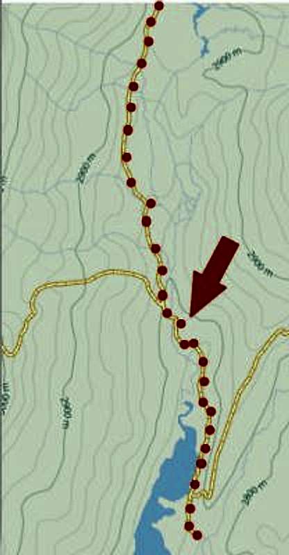
Continue on Trail #63 for approx 5.5 more miles (passing Lake Helen and Lake Marion) until you arrive at the south side of Mistymoon Lake. You will have gained approx 1100 vertical feet at this point. Many people choose to camp at Mistymoon Lake when making this an overnight trip.
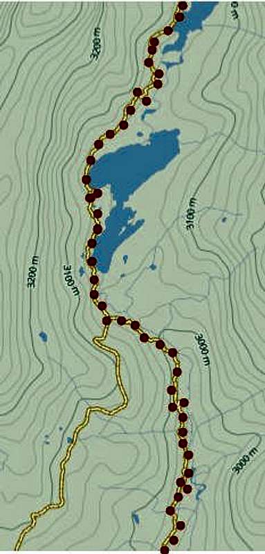
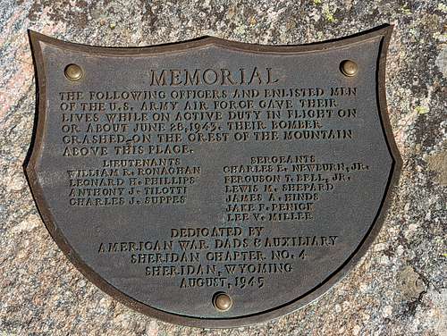
From there, go east on Trail #38 along the south shore of Mistymoon lake as you pass Fortress Lake (on your left/north side of the trail) and then Gunboat Lake (on your right/south side of the trail). You may not even see Gunboat Lake until you are already past it. Go approx 2.1 miles and gain another 500 vertical feet until you pass Florence Lake (on your left/north side of the trail). Once you get past Florence Lake, cross the creek and look for the very large boulder near N44 20.831 W107 10.692 and look for the large memorial plaque placed for the airmen that lost their lives in the B-17 bomber crash in 1945.
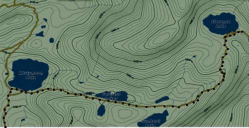
Once you get to the plaque, bear to the left (north) and follow the cairns along the eastern edge of the lake. You will see Bomber Mountain ahead of you and, depending on the cloud cover, you may be able to see sunlight glinting off of the exposed wreckage of the plane. Follow the shoreline until you get to a spot where the mountain goes down into the water making it impossible to continue without getting wet. Look up and you'll see a steep gully with a medium-sized section of dark colored rock to the right; follow the cairns up this gully (as shown in the two photos below), then bear to the left at the top and cross the wide open valley.


When looking up at the ridge, you will see a large section of rock that is a much darker grey/black than the surrounding rock; the easiest route goes above this rock section as it's a much more gradual climb. Go up towards the right side of this grey/black rock and you'll find another gully marked by cairns to climb. Once you get up, bear to the left and make your way up towards the ridge.
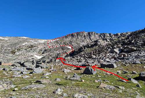
Once you gain the ridge, bear right and make your way up to the summit. You can also simply go straight for the summit once you get above the grey/black rock, but it's a much tougher climb requiring a lot of bouldering and route finding. It is approx 1.5 air miles and 1500 vertical feet from Florence Lake to the summit, however the actual distance you travel on foot will vary based on the lines you pick.

The return hike is simply the reverse of the above info. Round trip mileage is 22-24 miles.
Red Tape
There are no fees required to climb, however you must self-register yourself or your group at the kiosk at the trailhead.
Essential Gear
- A good pair of trail running shoes or hiking boots is recommended
- Sunscreen and insect repellent
- Adequate water and nutrition (Treating water sourced from rivers or lakes in the backcountry is a must!!!)
- Dress in layers and be prepared to add/remove them as needed.
- There is ZERO cell coverage anywhere near the trailhead or along the trail, but there is good Verizon coverage at the summit.
Tips
If you are starting from the trailhead, leave early so you can get up to the summit and back down before the afternoon thunderstorms roll in. Even strong hikers can expect 8+ hours for a round trip hike.
External Links
Add External Links text here.
Table of Contents