![North Peak of Bruin Mountain]() The northwest aspect of Bruin Mountain, north
The northwest aspect of Bruin Mountain, north![Upper Hazard Lake Trail]() Hazard Creek Meadows
Hazard Creek Meadows![Ascending West Ridge]() Starting the west ridge
Starting the west ridge![West Slope of Bruin Mountain, South]() Upper west slope
Upper west slope![The Summit Ridge, Bruin Mt. North]() Part of the summit
Part of the summit![Upper Hazard and Hard Lakes]() Upper Hazard Lake from the summit
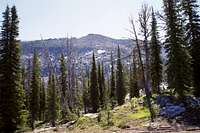
Upper Hazard Lake from the summit![View North from Bruin Mountain, North]() North from summit, Hazard and Lower Hazard Lakes
North from summit, Hazard and Lower Hazard Lakes![North Face of Bruin Mountain North]() North face
North face![West Side of the North Ridge]() North ridge
North ridge
I had been looking forward with anticipation all winter of climbing the north peak of Bruin Mountain to go along with my ascent of the south peak the previous fall. I was blessed with perfect sunny, but not to hot weather to make the attempt and as always I left home before the sun for a long day trip. The drive down was getting a bit boring since I have made it so many times that past three summers and I realized that though there were still some nice mountains up this road, I really wanted to spread out into another area. But that wouldn’t be today.
My hike started at the trailhead going south from Hazard Lake Campground a couple miles north of the mountain. The trail was quite level to Upper Hazard Lake and passed through delightful meadows filled with spring and early summer wildflowers. The meadows were saturated with snow melt that left many areas boggy or running with ephemeral streams. Lower Hazard Lake and Hazard Lake are two large bodies of water situated in large flat glacial valleys, which is atypical of most lakes in these glacially carved mountains. Upper Hazard Lake is more typical being found in a spectacular setting at the foot of the rugged south peak of Bruin Mountain. Though the south peak is a bit lower than the north peak, its north side makes it the more beautiful and awe-inspiring mountain. Upper Hazard Lake is the type of place that screams, “camp here!”, but unfortunately I could only spend a few minutes admiring it before heading up the ridge on the north side that would serve as my route up the north peak of Bruin Mountain.
The ridge I would follow would connect to the lower west slope of the peak. My route was simple; just follow the ridge and then go straight up the talus slope on the west face to the summit. On the ridge I got my first excellent views of the lower valley I had hiked up. The entire area was a skeletal forest of dead trees that were killed in the huge fire in 1994. How different this place must have looked with the base of the granitic peaks and deep blue lakes were embedded in a sea of deep green forest. Generally fire is a positive rejuvenating force on the natural landscape, but when its this massive, the results are tragic. There were a few ledges to pick my way around coming off the ridge at the lower slope of the peak, but nothing noteworthy.
The ascent up the west side was also quite straightforward and consisted of scrambling up a huge talus slope of granite boulders. The only bit of route finding required was taking an appropriate line to avoid occasional larger gaps or rocks that couldn’t be spanned or hopped. At the top of the talus I entered some stunted small whitebark pine that formed a strip along the top and in just a short time was on the top of the summit ridge. The long ridge is composed of huge black lichen encrusted granite blocks that were difficult to get on top of. There could be some real serious bouldering here for those into that. The angular blocks were fairly level over the entire reach and it took some looking around to determine exactly which one was the high point. There may have been a summit register, but I couldn’t find it.
I took lunch on the south end of the ridge promontory to enjoy the view south down the Long Valley beyond McCall. The Lick Creek Mountains with all those glacial horns were to the southeast and to the southwest were Granite Mountain and Slab Butte, which were old friends from previous years. Dominating the view however was the huge northern cliffs and snow fields of the southern peak of Bruin Mountain. To the west I could see the West, Cuddy and Seven Devils Mountains. This peak seemed to be in a very key position to see so many of the mountains of west central Idaho. Nearer to the west were the local group known as Grassy Mountain, which is actually an approximate cluster of peaks that gives this sub-range of the Salmon River Mountains it name. Not sure how this happened however, because they are among the smaller peaks in the area. There were not far off the road and I was on my goal by lunch so I started thinking again. Maybe I could stuff in a multiple peak day hike. The previous fall I did that and really wore myself out, but this was a new year and the mountains generally take over my mind on such beautiful days.
I intended to hike the north ridge of the peak out to a road on the ridge directly above and east of Hazard Lake, then cross country down the slope to the lake and trailhead. Much of the ridge was gentle and would provide a nice subalpine hike near the timberline, but I knew there would be some difficult sections. From the awesome north slope of the horn I headed north and met little trouble at first. The ridge soon was impassable on the east side, but the west side was certainly doable. It looked like I would need to cross the ridge to the east eventually as that is were most the passable surface would be found as I neared the easy rounded ridge toward the road. But I never got to what appears to be a notch providing that opportunity. Dropping down a bit rather than climb up one section I chose not to, I found myself a fair bit lower on the west side than I wanted. To work my way up would have taken a lot of energy and increased the time I needed to get out on my original idea.
So I thought I would just bail off the west side, hit the meadow, pick up the trail and have an easy walk back to the trailhead. But it wasn’t as straightforward as I had hoped. Soon I was standing on a bluff that had high cliffs on every side except the way I had come. So backtracking a bit was necessary before I could start down again. Looking back at the main ridge above, I saw the most rugged rocks and cliffs on the entire mountain were on my side of the north ridge. If I had kept going I would have had to get on the east side somewhere soon. I think if I had worked more to stay near the top earlier, I would have found a crossover and believed I could see some options. I think they cut through to the easier part of the east side, but need to check it out. Perhaps on another day I’ll start were the road crosses the ridge further to the north and work my way back to the peak.
Working my way back to where I could start down again, I soon was on gentler slopes that were swept smooth and rounded by years of extensive seasonal waterfalls and run off. It was an exceeding beautiful area despite the skeletal forest below. There were many ledges providing terraces for boggy and mossy ground that were bright with wildflowers. I even found a small patch of
Saxifraga bryophora tobasiae, which is a tiny plant with a worldwide distribution limited to a few peaks found in this immediate area. It took much longer than I had planned, but soon I was in the meadow below looking for a way to cross the swollen stream. Finally finding it, I was soon on the trail and back at the trailhead. Rather than a leisurely drive out of the mountains after another successful day, I hustled down the road to see if I could make another trailhead before it was too late for a double header.
Comments
No comments posted yet.