
|
|
Route |
|---|---|
|
|
43.30432°N / 110.60915°W |
|
|
Hiking |
|
|
Spring, Summer, Fall |
|
|
Most of a day |
|
|
Overview
This is a mainly on-trail route to the top of Cream Puff Peak, prominent in view when driving south from Hoback Junction. It's the one on the left right before entering Hoback Canyon. It's roughly 12 miles round trip ~3500' elevation gain, and once near the upper part of Cream Puff, there are a few other similar peaks that one can hike to.
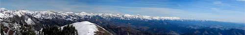
Views of all the surrounding ranges, from the Wind Rivers to the Tetons, are incredible. One of the better views in the southern GYE that I've seen.
Getting There
Drive south from Hoback Junction approx. 8 miles (I need to check this), to Bull Creek. You can pull in on the left, after crossing the Hoback River the second time (the river will be on the right side of the road). It's also just south of the green & white sign that says 'Entering the Sublette County Water Conservation District.' There isn't an official TH or sign, just a two track 'road' going uphill. I parked right here by the road.
Route Description
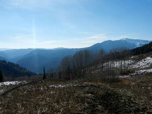
Walk uphill on the two-track for a couple hundred yards where it will intersect a trail. Take a left here and follow the trail. According the map I have, it's 4.2 miles to the 'base' of the peak. The trail ascends the Bull Creek/Cow Creek drainage, gradually gaining elevation. Ramshorn Peak will become visible across the valley behind you as you gain elevation, and the Gros Ventres will become visible as you reach the top of the drainage.
At the top of the drainage, one will go over a 'pass' and there Cream Puff will be visible to the left, and a related lower peak, on it's right side, with a fairly level ridge connecting them. Follow the trail to the base of the right hand peak, losing some elevation on the way. At the base of the right-hand peak's lower slope, look for a trail that enters the conifers. The trail ascends the rather steep slope with some switchbacks, and exits the forest at a shelf.
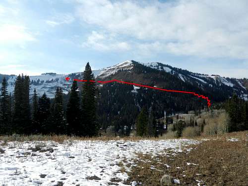
Here the trail becomes more faint, or at least it did when I was there, which was mid-October, with some snow on the ground. The idea is to traverse toward the base of Cream Puff's upper peak, gaining elevation while crossing the basin. According to the map, there is a trail that traverses this slope, but I couldn't find it. Instead I followed some game trails, up toward the right-hand peak. It was steep, vegetated and slippery, typical of the slopes here. I made it to the ridge and walked across to Cream Puff. Here the route should be fairly obvious, follow the ridge up, heading due south, the first peak is not the true summit, which is a short walk away.
On the descent, I followed game tracks down through the basin, attempting to the find a trail. While there were game trails here, they were discontinuous, and I had to avoid some crumbly cliffs at one point. It's a great summit, but if you're hoping for well manicured trails, you'll be disappointed by this upper basin. But in return, you'll get to visit a summit that likely sees few people, in a range that's quite wild.
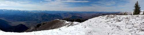
View from Cream Puff Peak
Theoretically, this could be done in winter, but would be much more involved. Things to consider are TH access, avalanche danger, cornices, etc.
In autumn, there was little to no water on the route. There are plenty of places to pitch a tent if one wanted to, but water will likely be scarce.
Essential Gear
Standard hiking gear, map, etc. Whatever you usually use. In early season axe and crampons may be desired.
External Links
http://www.mountainweather.com/