
-
 10763 Hits
-
 78.27% Score
-
 9 Votes
|
|
Route |
|---|---|
|
|
50.97572°N / 115.17517°W |
|
|
Hiking, Scrambling |
|
|
Spring, Summer, Fall |
|
|
Most of a day |
|
|
easy |
|
|
Overview
The summit of Mt. Allan is one of the most popular peaks in all of Kananaskis. Rivalled only by Ha Ling to the west, Allan may attract dozens of summits per year. Survyed in 1984 as the location for the 1988 Calgary Olympic Alpine Skiing event, this mountain has been entered into numerous climbers and hikers summit logs. You will gain 1350 m in 11 km on this trail along with some great views. Mt.Allan from the summit of Olympic Summit.
There are no ski runs located directly on the Allan summit as all are located at Nakiska Ski Area on Olympic Summit further southeast. Nakiska is known for being the closest ski hill to Calgary, AB and attracts 100's on the weekends throughout the winter.
Centennial Trail is the normal route to the summit of Mt. Allan. This trail leads up the southeastern ridge of Olympic Summit then on to Allan. If time permits one can keep hike on to Mt. Collembola to bag all three in one day.
 Looking down Centennial Trail on the accent of Olympic Summit.
* This trail is closed from April 1 to June 21 as the gentle slopes of Olympic and Allan are a breeding and lambing ground for the Big Horn Sheep of the area. *
Getting There
If coming from Banff, AB or Canmore, AB you will take The Trans Cananda east for 30 to 40 min. and if venturing from Calgary, AB a good hour west. From either location the overpass you will be exiting at is Highway 40 - South ( Kananaskis Trail ).Kananaskis Trail is a beautiful Front Range highway. Drivers will pass some breath taking scenery on the drive to Allan. Mt. Baldy, Mt. Lorette, Wasootch Peak and Barrier Lake are some sights you will observe on the first leg of this road.
Roughly 20 mins after exiting off the Trans Canada you will come across the Kananaskis Village and Nakiska Ski Area turn off on the west side of the highway. Mt. Kidd will be in plain view to the southwest. Turn right here and cross the gorgeous Kananaskis River. Your first left will be your next turn and then the first right after that. This is the Ribbon Creek Parking Area and Hostel.
 Looking West down the Bow Valley. Canmore, AB in the middle-right of this shot.
After parking, look for the trailhead at the north end of the parking lot. Here you will find some signage on the Centennial Trail. Enter the trail here and keep to your left and avoid crossing the small creek as this is the wrong way.
The trail is initially the trail is marked "Hidden Ski Trail" but later leads into Centennial Trail and to the summit of Allan.
Route Description
The beginnings of this hike lead you through a Poplar Forest, but as you gain elevation you will find yourself in a dense Logpole Pine woods. The trail will start quite wide but then thin once in the pined forest.Once you exit this pine forest you will find yourelf on the open slopes of Olympic Summit. Here the trail is well marked with cairns and some poles with red marker tape attached. Most of this hike is on the southeastern ridge and gives you great views of the Kananaskis Valley, Mt. Kidd, Mt. Bogart and The Wedge to the southeast.
Once you near Olympic Summit's highpoint, there will be a short, easily traversed rock band. As you walk along Olympic Summit's summit ridge you will get your first views of Mt. Allan. Also there are a few weather station on this summit and a view of the Gold Chairlifts of Nakiska Ski Area.
The next leg of this climb leads you though a beautiful pinnicle field. Some of these pinnicles raise 40 to 50 ft off the Olympic-Allan col and are the most photogenic part of the hike.
Once you reach the base of Mt. Allan the hike becomes more scramble-like. Scree and a small amount of slab will accompany you to the Allan summit. Once on the summit you will have some spectacular views. Mt. Lougheed towers to the SW of you, Canmore, AB and Cascade Mountain are in the west. Looking east of a clear day you will see the skyline of Calgary, AB over 100 km away.
This is a hike that everyone visiting or living in the area should try once. The views are beautiful and the hike delightful.
Essential Gear
A good day pack with some sunscreen and snacks are a good start. I would bring trekking poles or find a good hiking stick in the woods at the beginning of this hike. This comes in handy on the decent. Bear spray is always a good idea also. Bears are abundent in Kananaskis and have been seen on the slopes of Nakiska throughout the spring and summer months.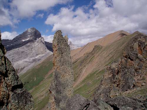 Some of the pinnicles on your trek. Allan in the background.
Don't forget your camera. The views are beautiful and there is tons of wildlife on this trek.