
-
 9232 Hits
-
 79.04% Score
-
 10 Votes
|
|
Mountain/Rock |
|---|---|
|
|
35.59520°N / 107.3186°W |
|
|
Mckinley |
|
|
Scrambling |
|
|
Spring |
|
|
7608 ft / 2319 m |
|
|
Overview
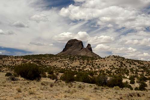
Cerro Parido is an isolated steep volcanic neck at the north end of Chivato Mesa just west of the Rio Puerco Valley. Thought to be around 3 mllions years old, this mitten-shaped volcanic plug rises at near vertical angles from all sides and is covered with thousands of cacti of many different species. Such an environment makes this peak an excellent location for Golden Eagle nests.
The Jemez Mountains, the San Pedro Mountains, Cabezon Peak, Cerro Cuate, the expansive desert of the Chaco Canyon area to the northwest, and other interesting desert landmarks are visible from this peak. The easiest route consists of a long scramble, 4th class, and low-5th class climbing higher up the peak. The elevation gain is anywhere between 1,000-1,250 ft., depending on where you start the ascent. Since it is so far out of the way, even from the Cabezon area, this peak has nearly zero human traffic.
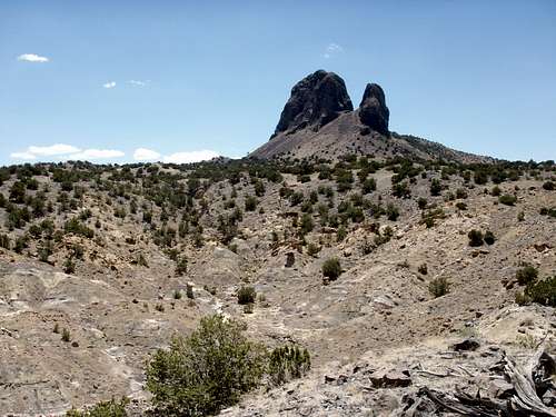
East Face of Cerro Parido
Getting There
_Drive north on I-25 to Bernalillo from Albuquerque and take exit 242 onto US-550. Travel west through Bernalillo (1 mile), and northwest to San Ysidro (22 miles), and then an additional 19 miles to the turnoff to the villages of San Luis, Cabezon, and Torreon, which are on NM-279. It is a paved road for a couple miles past the village of San Luis and then becomes an equally wide dirt road around 8 miles from US-550.
_The main road takes a sharp turn to the right at a sign that warns you to slow down to 15 mph; another road you don’t want to take continues straight forward. After half a mile the road forks; stay right.
_You’ll pass Cerro Cuate and reach another fork; go left. This road goes down from a sandstone mesa to the Rio Puerco and crosses it at a one-lane bridge. Continue straight for another mile and turn right at a fork at the base of Chivato Mesa (left takes you south). Drive up onto the bench into the pinon and juniper. Immediately after a kiosk with a map, turn right. A series of descending turns lead to a gate, which may or not be open. It is okay to enter, just leave the gate as you found it after you pass through. The road travels further down into a small valley and climbs up another sandstone bench where it turns pretty rough (4-wheel drive/high clearance recommended). Another 3 miles of driving up and down gullies and bluffs will put you within striking distance. The closest road to the peak is actually to the northwest of the peak when the road turns south to cross a ditch.
Red Tape
There are no fees or permits.For further information take the link below to the Bureau of Land Management Field Office in Albuquerque.
BLM Link
This picture was taken on top of a ridge in the arroyo halfway between the dirt road to the northeast and the peak. (June 10, 2006)
When to Climb
The peak is climbable at all times during the year. The best periods are between March and May and also between August and November. The summer months can cook the mountain to unbearably hot temperatures and ice thawing in the afternoon during the winter can give way to rockfalls. Due to the dust, dry air, altitude, and intense sun that drain you of water, it is important to pack plenty of it (a couple of liters is good). It's best to leave early in the morning to beat the heat.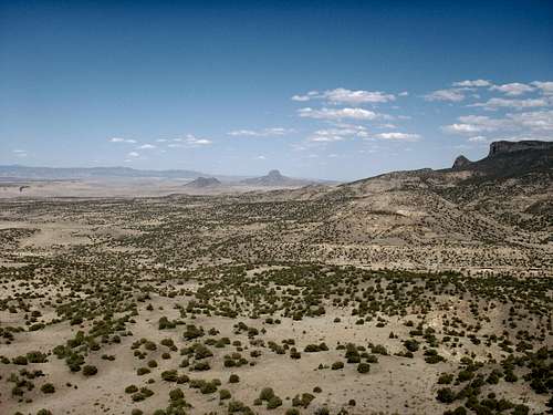
From the left to right: Cerro Cuate, Cabezon, and La Boca del Oso.
The picture was taken from the saddle between the two spires of Cerro Parido.
Mountain Conditions
San Ysidro is the closest city or town to the Cabezon area at around 25 miles to the east.Weather at San Ysidro
Camping
The peak and surrounding areas are on BLM land and there are no camping restrictions other than the natural features. There are plenty of flat areas without cacti that can serve as camping sites.Conservation Campaign
Currently, the Cabezon Wilderness Study Area, which is run by the BLM, protects the land around Cabezon Peak to an ambiguous extent. Yet, the land surrounding the other volcanic necks in the region remains unprotected.
“The BLM is directed to preserve the wilderness values of the Cabezon Wilderness Study Area (WSA) for the long term. This involves protecting the area’s special features and natural qualities, including outstanding opportunities for solitude and primitive recreation. Preserving wilderness values is a difficult task that requires a commitment from you as well as the BLM. The challenge for land managers lies in making sure the use of the other resources and activities within the WSA is compatible with its wilderness resource. The challenge for you is to use the area in harmony with the wilderness environment.
You do not need a permit to climb Cabezon Peak. However, permits are required for most uses other than primitive recreation, including mineral exploration, grazing, outfitting/guiding, commercial filming, and scientific research.”
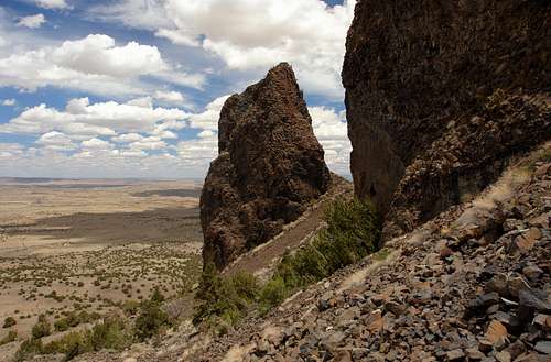
Cerro Parido: approaching the base of the west face. The detached rock tower UN 7,394 is seen in the center. 05-22-2011
Cabezon Peak Pamphlet by the BLM
This method the BLM uses is insufficient for the protection of these great landmarks in the New Mexican landscape. The door stays open for those who would seek profits at the expense of others’ enjoyment. The desert environment is fragile by nature and takes many years to recover from harsh treatment. Already, heavy grazing by cattle has reduced many portions to near badland-like conditions, which exposes the land to erosion. Another detrimental effect from local ranchers is the use of cyanide on coyotes, which makes its way into the food chain, eventually affecting most fauna including birds of prey. Closed gates on public roads also restrict access to these public lands.
An experiment designed to measure the effects of grazing on vegetation is being planned at the moment and will produce results within the next five years. In the mean time, an effort must be made to create more protections in the Rio Puerco Valley and open up the public lands for more uses than just cattlegrazing.
Some solutions are managing the cattle grazing in a way that would reduce the harmful effects on the vegetation. If the frequency that a certain portion of land is grazed is reduced and rotation of cattle herds through these areas is organized more properly, such effects could be reduced.
Another is making the region a national monument or enveloping the whole valley under the blanket of the wilderness study area. There are many other ways to improve the management of this land. Your ideas and contributions are essential for progress to be made.
Public opinion is a great vehicle to get this moving and the links below are to help with that.
New Mexico BLM Feedback Page