
-
 8728 Hits
-
 80.49% Score
-
 12 Votes
|
|
Mountain/Rock |
|---|---|
|
|
13.39873°S / 72.6064°W |
|
|
Hiking, Mountaineering, Scrambling |
|
|
Spring, Summer, Fall, Winter |
|
|
17868 ft / 5446 m |
|
|
Overview
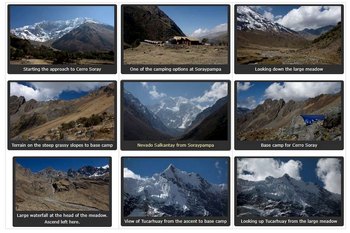
Located in southern Peru about 2 hours west of Cusco by bus/van is the small town of Mollepata, and the tailhead for the now famous Salcantay Trek is another hour up a long gravel road. At the end of this gravel road there is a small village called Soraypampa and Cerro Soray rises directly above this village to the west. This peak makes for a nice climb offering fantastic views of Salkantay and Tucarhuay, which are two massive glaciated peaks in the Vilcabamba Range. Climbing in this area is largely unexplored and literally brand new, with just a small handful of people in Cusco actually making ascents of the high peaks in all of southern Peru. While Salkantay (the highest mountain in the Vilcabamba range at 6,279 meters), is a very difficult an committing climb that has seen few ascents, Cerro Soray can be climbed without technical gear of any kind, and makes a good solo outing for someone passing through without a climbing partner.
The standard route up the north face involves a hike up a decent trail from Soraypampa (elevation 3,900 meters) to a high alpine meadow, followed by some steep grass/talus hiking to a small base camp at about 4,800 meters which makes a great camp. SP member SkyHighAndes has built a couple very nice rock walls to protect tents from wind and give you some decent storm protection in case you get caught. He, or one of his assistant guides often take clients up this peak either to acclimate or for an easier objective. If you are however already acclimated and have climbing experience, there is no need to hire a guide, and it's easily done as a solo outing.
Beyond the base camp the ascent continues up some very loose talus, around the fringe of one dying glacier and up a steep talus gully to the base of the upper glacier which involves 50 meters or so of at most 35 degree snow. The route finishes off with a Class 3 ridge scramble.

Cerro Soray Standard North Face Route Topo - Taken by Sky High Andes
Getting There
Getting to this peak isn't too difficult. From Cusco you will need to go to the intersection of Arcopata and Av. Abancay in the far western end of town. Here you will find 10-12 passenger vans (collectivos), heading to Mollepata on a somewhat regular basis. If you can't find their exact location, just ask anyone in the area where the vans for Mollepata are. They leave when full and the ride takes about 2 hours. There are a few small shops and restaurants in Mollepata, as well as a few hostels. In the small Plaza de Armas, you can usually find a taxi up to Soraypampa anywhere from 75-100 Soles depending on your negotiating skills. Plan on about 4 hours to get to Soraypampa, and if you leave Cusco early enough (before 7am), you can still probably make the approach to base camp before dark. Otherwise you can stay in Mollepata and take the taxi to Soraypampa the next morning.
For the approach to camp you have a couple options. If you arrange ahead of time, you can have Antonio Huari aid you with your ascent by carrying your gear on his burros to base camp. He also knows the best way to get there, however I do not recommend this. It is both unnecessary and expensive if you are traveling solo or with just one partner. Instead, locate Antonio's property which is just past the very fancy Chilean Salkantay Lodge (can't miss it!) on the left side of the road before you would cross the river draining from the north side of Cerro Soray, and Laguna Tucarhuay. He has 5-6 large silver/blue domes on his property. If he is around, you can simply ask him if you can pass through his yard to catch the trail that continues beyond his home and up above the left side of the river. If he's not around, there probably won't be anyone stopping you from just walking through his yard to catch the trail, which leads to the large meadow at 4,240 meters. You do not want to hike to the lake as there is a large glacial moraine that separates the lake from the large meadow.
Alternatively you can hike beyond the stream and pass through any one of the small camping areas with the large army type tents lined up and begin hiking the trail towards Laguna Tucarhuay (popular tourist hike), then cut left (south) once you are sufficiently beyond all the homes etc, but before you reach the moraine. Cross back to the south side of the creek and find a good roue up the hill until you meet the nice trail. Once in the meadow it is a long flat walk through beautiful grasslands where you will find cows, donkeys, and llamas. At the head of the meadow, shortly after the terrain begins going uphill again, you will notice a huge waterfall dumping off from Point 5,370 meters. Before reaching this waterfall, begin ascending SSW up the grassy slopes, aiming for a small rocky peak. This final ascent to base camp is 400 meters and is the worst part. If you went light and aren't carrying much, and already acclimated it goes by quick and you can get to this 4,800 meter camp in just 2-3 hours from Soraypampa. With more/heavier gear and no acclimatization you'd probably take 5-6 hours. See the map below for an overview of the correct approach route.
*Note that the maps and guidebooks call the 5,917 meter peak just north of Cerro Soray across the valley Humantay, when this peak is actually Tucarhuay.
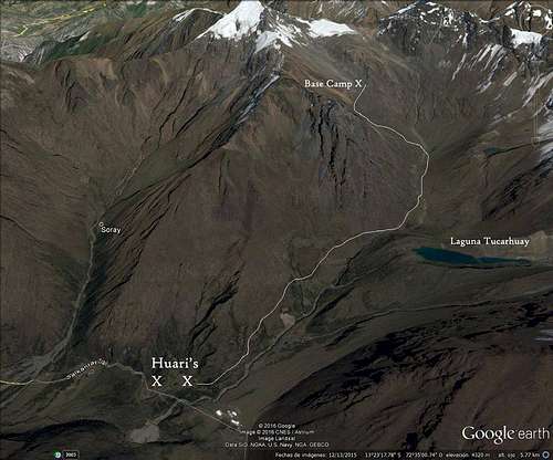 Approach map for Cerro Soray Base Camp
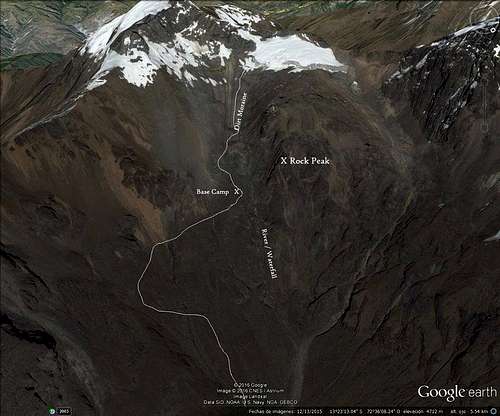 Detail map of area around Cerro Soray base camp
Standard Route - North Face Class 3
From base camp, continue directly up just below the rocky buttress to the right of camp (looking uphill) and up the loose scree on the moraine. Do not traverse left onto the top of the lateral moraine. You may find a small path with footprints. Continue up to the base of the small glacier, and skirt around to its left edge. You can walk on its edge for a few minutes after getting above the steep icy toe to bypass some of the awful talus, but this will be futile as you will have plenty of loose talus to deal with on this route. Once you reach the upper end of the glacier at about 5,000 meters, there will be a large open scree/talus slope directly above you to the south. Climb this slope trying to find solid rock where possible but unless this slope is snow covered, this part of the route really sucks.
Aim for a deep gully at the top of the talus slope where you will find a 10 foot chimney with a chockstone in it. This is the crux of the route and goes at about Class 4 without much exposure. Once above the chimney, continue up the gully until you reach the second dying glacier. In late season (July-September) there will be large nieves penitentes in the snow making for easy footing as you ascend this 30-35 degree snow for about 50 meters where you'll reach the northwest ridge. Continue following the snow up the ridge until it ends, then scramble up the Class 2-3 ridge to the summit staying on the right (west) side of the crest for the easiest terrain. See the route photo at the top of the page in the overview section for a good overview of the route from base camp. Plan on 4-6 hours round trip from base camp.

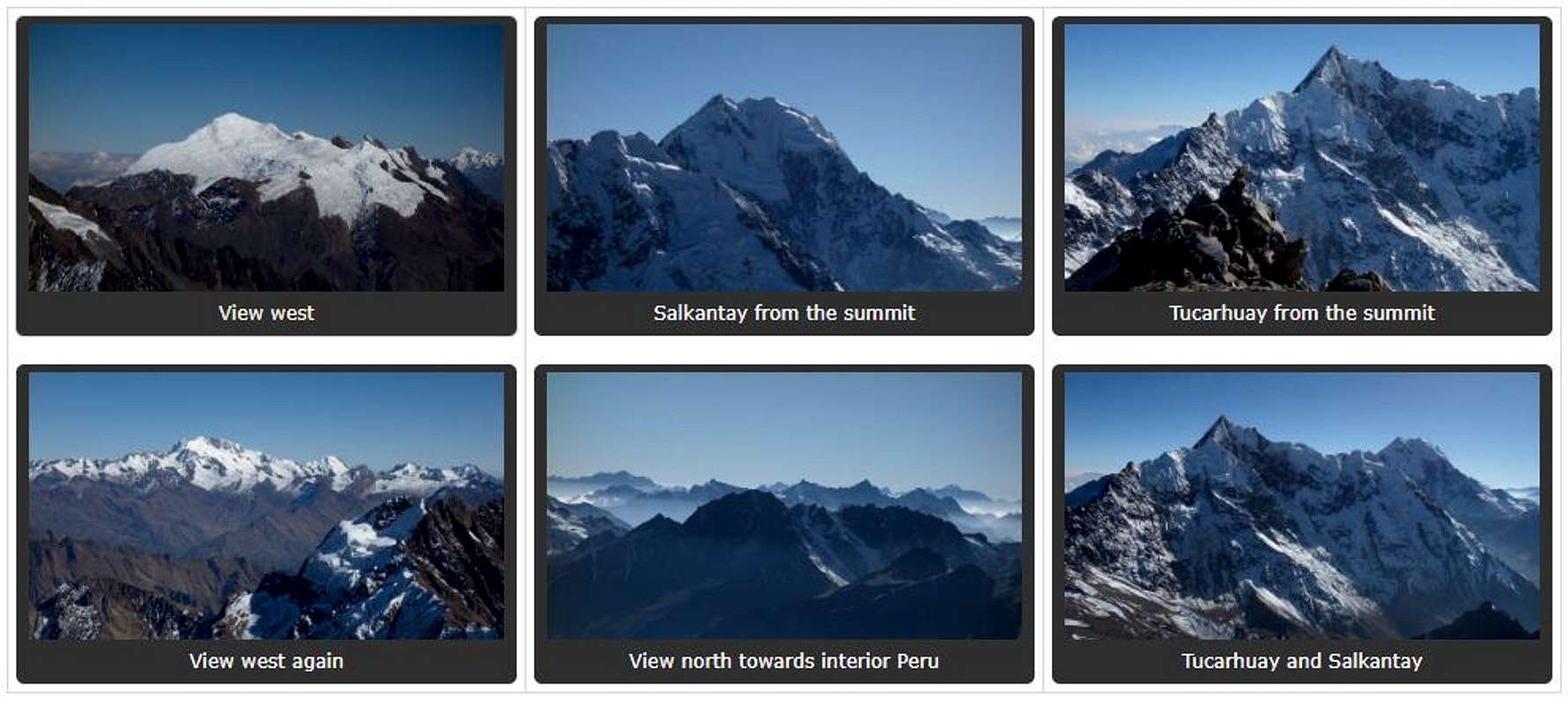
Summit Views
Camping/Red Tape
No red tape! Please leave no trace and be respectful of the locals. This entire area is their land and they are generous enough to allow hiking and climbing.
When to Climb
The best time to climb would be from May - September when Peru is in their dry season. May and June will see more snow on the route and may require crampons and mountaineering boots while after mid-July here will be very little snow remaining, and the route can be done in tennis shoes and microspikes with a small axe. The weather is very stable in the dry season but clouds do roll in from the east in the afternoons. Plan to be off the summit by noon.
External Links
Sky High Expeditions guiding service and info