
-
 9246 Hits
-
 75.81% Score
-
 6 Votes
|
|
Route |
|---|---|
|
|
39.11280°N / 104.9302°W |
|
|
Hiking |
|
|
Spring, Summer, Fall, Winter |
|
|
Half a day |
|
|
Class 1 on-trail walk-up |
|
|
Overview
This trail does not appear on any map I possess of this area, including the Pikes Peak Atlas. A thorough web search of trails, open space, recreation areas, etc., in the area yields zero knowledge of this trail. By most accounts, this trail does not even exist.But it does exist. And it’s in surprisingly good shape. Sure, it’s steep and rutted in spots, but it winds a surprisingly gentle switchback from Monument Creek to the summit of Chautauqua Mountain. The greatest challenge posed by this trail is actually finding it. The “crux”, if you will, is locating the stream crossing and then following the unmarked trail initially westward after crossing Monument Creek. After this, the well-worn path whisks the hiker quickly up toward the top of Chautauqua Mountain.
Mileage: 2 miles roundtrip
Elevation Gain: 1,100 feet
Getting There
 Reservoir Trailhead to Chautauqua Mountain Trail
05 Apr 09
From the South:
- Exit #161 and turn left onto Highway 105. (The town center of Palmer Lake is about 4 miles away.)
- Turn west/left onto South Valley Road.
- Turn left on Old Carriage Road.
- The Emory Hightower Trailhead parking area is at the bottom of the hill at the sharp curve. Note: The trailhead sign reads the nicknamed “Reservoir Trailhead” instead of the official “Emory Hightower Trailhead”.
From the North:
- Exit 163, turning right onto County Line Road. (The town center of Palmer Lake is about 2 miles away).
- Cross over the railroad tracks onto Highway 105 and pass through town.
- Turn west/right onto South Valley Road.
- Turn left on Old Carriage Road.
- The Emory Hightower Trailhead parking area is at the bottom of the hill at the sharp curve. Note: The trailhead sign reads the nicknamed “Reservoir Trailhead” instead of the official “Emory Hightower Trailhead”.
Route Description
 Click map image to enlarge.
- Notice a trail heading west into the woods. On either side of the trail are signs. The one on the left states the rules governing usage. The one on the right indicates this is the Reservoir Trailhead.
- Head south / to the left, toward the lower route (behind the usage sign).
- Follow Monument Creek upstream, keeping your eyes peeled for a creek-rock stream crossing.
- After crossing the stream, turn right. The Chautauqua Mountain Trail will soon begin climbing.
- Note: The trail after this point is well-worn enough that the route was apparent, even in 6-8 inches of fresh powder.
- The route steeply switches back, eventually gaining a ridge.
- Begin the final push toward the first of three highpoint candidates, following the north slope to an outcrop.
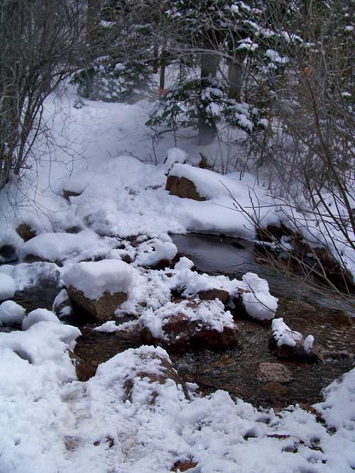 Keep an eye out for this stream crossing
05 Apr 09
Note that two additional highpoints present themselves upon obtaining the summit area. The first is nearby to the south-southwest. The next is across a gentle saddle to west. The eastern-most summits provide wonderful views, with an especially handsome angle on Mount Herman. The western-most summit is primarily shrouded in trees, but it corresponds to the highest point of the mountain on all maps I consulted.
 Do not be tempated to head up-slope yet
05 Apr 09
Essential Gear
- Trail map (Trails Illustrated #137 (Pikes Peak, Cañon City) would meet most needs)
- Compass
- Trekking pole(s)
- Sturdy hiking boots with grippy soles and stiff ankle support
- Snowshoes after a heavy snowfall
- Water and snacks
- A camera to save memories of the high country views
- First aid kit
- Other standard backcountry essentials
 Mount Herman through the trees
05 Apr 09