
|
|
Mountain/Rock |
|---|---|
|
|
49.19093°N / 121.67605°W |
|
|
Hiking, Mountaineering |
|
|
Spring, Summer, Fall |
|
|
6929 ft / 2112 m |
|
|
Overview
All reward 5.4mi, 2214ft elevation gain out-and-back hike (no real technical scrambling necessary) with beautiful overviews of the Fraser River Valley below. A more technical bushwhacking route is available from the North side of this climb, as witnessed by a paraglider in 2018 (though I am not as familiar with this route).
Getting There
From Hwy 1 heading East:
Merge onto Trans-Canada Hwy/BC-1 E. Take exit 104 for No. 3 Road toward Cultus Lake RECREATIONAL AREA. Keep right at the fork, follow signs for Cultus Lake/Number 3 Road E/Yarrow and merge onto No. 3 Rd. Turn right onto Tolmie Rd. Turn left onto No. 3 Rd. No. 3 Rd turns left and becomes Yarrow Central Rd. Continue onto Vedder Mountain Rd. At the roundabout, take the 2nd exit and stay on Vedder Mountain Rd. At the roundabout, take the 1st exit onto Chilliwack Lake Rd - Turn left onto Foley Creek Forest Service Rd (***THIS IS WHERE IT STARTS TO GET SPICY). Turn left to stay on Foley Creek Forest Service Rd. Foley Creek Forest Service Rd turns slightly right and becomes Chipmunk Creek Forest Service Rd. Turn right to stay on Chipmunk Creek Forest Service Rd - follow this road until it dead ends at a sizeable parking lot at the TH. Will want to get there early to ensure parking spot
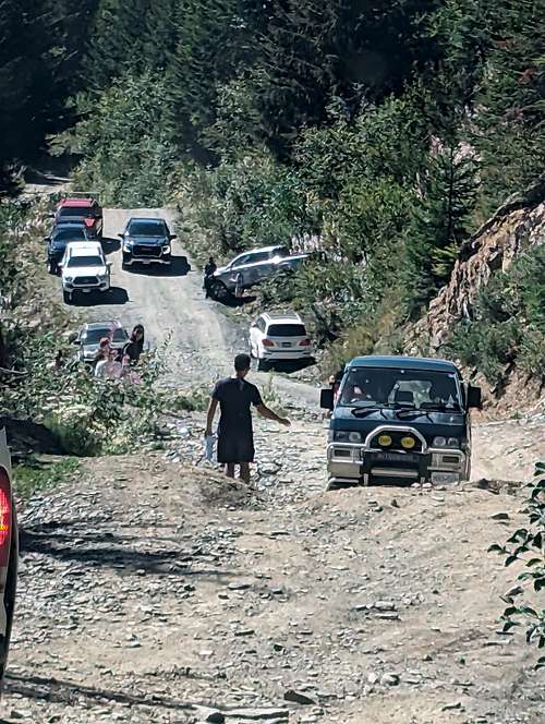
Truly the most challenging part of this climb is more the mandatory 4x4 road access which takes a savvy offroad driver 1hr + to navigate. Per All Trails: A high-clearance 4x4 vehicle is strongly recommended to reach the trailhead, as there are many sections on the road with deep cross ditches.
This is putting it lightly. My 16' Toyota Tacoma scraped on the rear tow hitch every swale cut into the road for erosion control the entire way up and down. I assisted a young gentlemen from the town of Hope who highpointed his low clearance sedan on a rock in the road, puncturing his oil pan, and draining it fully on the drive out. Not to be taken lightly ... image below taken in September 2023 at the large washout 1.5mi from TH
Route
Per All Trails: This is a very pleasant adventure in both directions leading to magnificent 360° views. With some of the best views of the Fraser River Valley, it is great to take during most seasons. The first incline that can hit folks hard but after that it’s fairly steady going, despite being almost all incline.
During most hiking times of the year, you will have to cross an ice bank and it is slippery. While folks in running shoes or basic hiking shoes will be fine, this section should be taken slowly. From there, the trail ventures through inclined meadows of wildflowers. Then the switchbacks start and the pathways are thin until reaching the start of the peak.
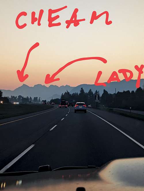
Even in early July, there will be plenty of snow covering these mountains. The trail at this time of the year can be not visible. If not properly prepared for this hike, it is recommended to stay on the grass as much as possible to avoid the snow and potential falls down the mountain. September is generally the best time to attempt this hike. It’s dry, the temperature is pleasant, and the bugs are gone. On the way down from Cheam Peak, you can also add Lady Peak to the south if interested, but this is more challenging and should only be attempted if folks have the proper equipment for steep climbs and lots of loose scree. (Lady Peak noted as type 2/3 scramble).
Red Tape
No camping at trailhead, and dogs allowed on leash. Be prepared to beat your vehicle up to get to the TH. Saw a ton of wildlife with an early start, including black bear - may want to bring bear spray if so inclined
Also per All Trails: It has been reported that using Apple maps for directions takes vehicles to an incorrect location near Bridal Veil Falls. Google Maps seems to not have this error occur.
When to Climb
Spring, Summer, Fall - unsure on Winter access or conditions
Camping
No camping at TH
External Links
Information gathered from personal experience and the following: https://www.alltrails.com/explore/trail/canada/british-columbia/cheam-peak?mobileMap=false&ref=sidebar-static-map&u=i