
-
 14161 Hits
-
 77.48% Score
-
 8 Votes
|
|
Route |
|---|---|
|
|
37.96152°N / 122.79419°W |
|
|
Hiking |
|
|
Spring, Summer, Fall, Winter |
|
|
Overview
The portion of the Point Reyes Coast trail from its southern terminus at the Palomarin trailhead to Double Point and Alamere Falls is one of the most spectacular trails in the San Francisco Bay Area. It combines sections of trail slung high above the sea, dense rainforest, and freshwater lakes. All of this compliments the fantastic views of the Pacific Ocean, a beautiful and unique waterfall and the chance to climb a high seaside peak.Route Description
 Double Point and Pelican Lake
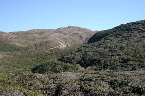
The Coast Trail begins in an attractive grove of eucalyptus trees. It initially travels inland, on the south side of Arroyo Hondo, which will generally have some water flowing in it. The trail eventually crosses the creek and turns west back toward the coast. The sound of the surf soon becomes audible and the trail will leave behind the eucalyptus, exposing excellent views of the Pacific Ocean. From here the trail turns northwest and beings to traverse the cliffs above the sea. The route is generally about 300 feet above Palomarin Beach and a few routes are visible leading down to the sand. As the Coast trail heads northwest, it travels in and out of a few drainages, but it generally maintains its trajectory. Double Point remains hidden from view.
After nearly 2.5 miles, the trail turns northeast, climbing up a gulch. Although the route turns back toward the ocean once it crosses the drainage, it turns north again and climbs east, up and out of the gulch. It reaches a pass at about 550 feet, before it levels off and begins to descend onto the plateau that contains the lakes surrounding Double Point. The Mud Lakes are the first of these bodies of water that the Coast trail encounters. The pools are small and uninviting. From the pass the trail begins to arc to the west, passing the Mud Lakes. Eventually Bass Lake comes into view. This lake is large and clear and groups of people can often be seen swimming in it. Although the Coast trail only skirts the north end of the lake a use-trail follows the rest of the shoreline. There is a rope swing on the west side of the lake.
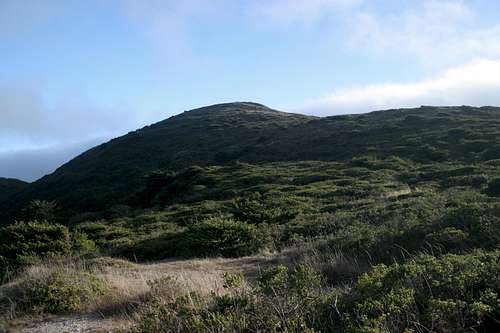
 Double Point from the Alamere Falls spur trail
After leaving Bass Lake, the Coast trail climbs another pass, although this one is lower and the elevation gain does not add any difficulty to the trail. The route now continues due west, and eventually leaves the forest cover and enters a large coastal prairie. Double Point comes into view for the first time, rising attractively from the shore of Pelican Lake. Although it is possible to descend down to the lake, the trail remains 200 feet above it. At the north end of the lake the Coast trail comes to an unmarked junction. Although the trail continues north, spur trails split off heading up to Double Point and down to Alamere Falls. A small sign was once placed at the head of the Alamere Falls spur, but it has since been overgrown or removed. Nonetheless, the route down to the falls is fairly obvious. The route to Double Point is a little less obvious and is found only a few yards prior to the Alamere Falls spur.
 Summit of Double Point
Double Point
From the junction, the route to Double Point travels due south, above the west side of Pelican Lake. The lake often has its namesake birds congregating in its waters. It is possible that a road may have climbed to the top of Double Point, because it appears that there are conflicting routes heading toward the top. One of the routes, although overgrown, is wide enough to have been able to accommodate an automobile. Either route will reach the top, but the one that heads toward the west side of the summit has better views of the coast and seems to be the actual trail. Either route has thick patches of poison oak along the trail, so caution should be exercised.
 Alamere Falls
Alamere Falls
From the junction with the Coast trail, the Alamere Falls spur descends to the west, following the gulch drained by Alamere Creek. The trail swings north, passing through an area of extremely dense brush. Poison oak is present, but is easy to avoid. The trail eventually swings west again, directly above the creek. The route then descends a badly eroded series of crevices. This drops directly between two of the cataracts above the main falls. The cataract to the right is the tallest and prettiest of the three. Cross the creek and approach the cliffs to see Alamere Falls spilling on the beach below. To get to the beach, there is a gully north of the falls that can be descended. Interesting strata can be seen as one heads down to the beach. Once on the beach, the falls and the base of Double Point are to the left. One can head north on the beach to get to Wildcat Campground.
Wildcat Campground
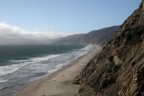 Wildcat Beach
From the junction with the Alamere Falls and Double Point routes, continue north on the Coast trail to get to Wildcat Campground. Shortly after the trail crosses Alamere Creek, the trail splits. Both routes lead to Wildcat Campground. The left fork is prettier, the right more direct. The left fork is the preferred route. It is not substantially longer, but travels directly above the surf and alongside Ocean Lake.
Map
 Coast Trail
Getting There
From San Francisco, travel north on Highway 101. After crossing the Golden Gate, exit onto Highway 1 and continue west. Pass through the communities of Muir Beach and Stinson Beach. Turn left onto Olema Bolinas Road. Turn right onto Mesa Road and follow it to the trailhead. The road will eventually become a well-maintained gravel road, about a mile before the trailhead.If coming from the north, one can exit Highway 101 at Petaluma and exit onto East Washington. Travel west across the Petaluma River and turn left onto Petaluma Boulevard. Turn right onto D Street. Remain on D Street which will eventually becomes Point Reyes-Petaluma Road. This road extends several miles to the west. At the stop sign, stay straight onto Platform Bridge Road. Turn right onto Sir Francis Drake Boulevard and left onto Highway 1. Turn right onto Olema Bolinas Road and right onto Mesa Road, which leads to the trailhead.
External Links
Point Reyes National SeashorePointreyes.net
Pointreyes.org