Add Heading Here
Short report here to add another perspective on the southeast gully route, from Pear....and a few other observations
Set out for an overnight at Finch (from Allenspark) and then climb of Copeland from Pear.
I fretted over finding and getting to the Allenspark trailhead in time to get a parking place. This approach to Finch is a bit shorter than from Wild Basin (and no park entrance fee).
I found the trailhead with no problem, following various instructions I found online. Strangely enough I could not find the trailhead from Google images.
Finch was awesome. The water was not even very cold. No mosquitos and few flies in spite of this being on a horse allowed trail.
Setup camp and hit the trail for Pear. Hoping that it would be only about 2 hrs to the summit of Copeland from Finch....Not!
From Pear the hulk of what
you think is the summit dominates. Actually the summit is much further west and out of view.
![copeland (not really) from Pear]() copelands east ridge from Pear
copelands east ridge from Pear
In spite of the warning in the route description I still made the mistake at Pear and did not stay near the north shore, but rather went up the trail past the bridge up the hill. I did not realize my error until I returned because there was indeed a big boulder on that trail too. From which I started bushwacking up the slope.
This resulted in probably considerably more work to get to the 2 lakes above Pear. While breathlessly climbing over logs and thru branches I almost had a coronary as what looked like a rattler was in my path a few feet ahead.
![fungus]() Yikes! what is that!
Yikes! what is that! Of course the conscious mind was not given time to process that there would not be a rattler at 11k ft.
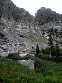
This approach also put me on the opposite side of the lakes from the gully. From that vantage point the gully looked to loose and steep for a solo climb. In hindsight, on my return, looking up from the bottom of the gully it did not look that bad
![south east gully of Copeland]() looking up the SE gully from the lakes at 11k
looking up the SE gully from the lakes at 11k. Still, climbing solo it might not be wise because if you get hurt it might be a loooong time before someone else is in the area.
The climb from the lake around to the east of the somewhat nasty looking knob was not too bad...but not great fun either. All to be rewarded with a very steep (but solid and not risky) boulder field to get to the top of the gully.
One again, on the return, my hindsight became sharply in focus....I should have gone north a bit more as the east slope is less steep just a bit further north.
What to compare the 2k of the east slope? Well perhaps like Mt Lady Washington. Nothing interesting to look at and endlessly long. At least the boulders and steepness eases a bit in the 2nd half. The one thing I did right was to have my GPS so it would not allow me to be delusional about how close I thought (hoped) to be to the summit. The elevation reading made it clear that each hump above on the horizon was NOT the summit.
In terms of time to the summit, I left Finch at about 10am and did not summit until 1:40. Since I had packed in that morning I was seriously whooped. I thank God that the weather held that late in July.
Awesome views of Elk Tooth, Ogalalla, Cony Lake, and Bluebird, Pipit lakes to the NW.
On the return down the east slope I took another look at the gully and came to the conclusion I mentioned earlier
![looking down SE gully]() looking down the SE gully
looking down the SE gully. It would be fine; but perhaps not prudent as a solo.
Back at the high lakes I went on a more direct line down the drainage to the north shore of Pear. It was much easier traveling, not as steep or as many down trees.
![beautiful fungi]() more friendly looking fungi
more friendly looking fungi
In my planning I had considered bushwacking directly from Finch to the east slopes, bypassing Pear. On the return down the slope I considered how that might be. I am guessing it would not be any better even though it is more direct, because of the extra effort bushwacking. It would also be possible on the return to end up in the other drainage and miss Finch. So I guess my foresight is not always wrong.
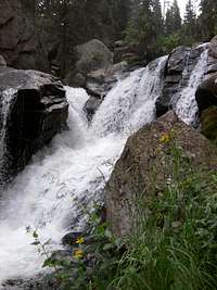
The next morning, back at Finch, I wanted to get to Calyspo cascades and Ouzel Falls. But I did not want to have to hike 10 miles to get there and back! So I bushwacked north, downhill. It was fun hearing each of the two streams coming together as I approached the top of the cascades. I was surprised at the beautiful falls which you would not see from the main trail below. Keep in mind though that you need to get to either side of both of these before they get to raging below. I was surprised at how much runoff there still was in late July of a dry year. No obvious drought up here.
![falls above Calypso Cascades]() falls above Calypso Cascades
falls above Calypso Cascades


Comments
Post a Comment