
|
|
Route |
|---|---|
|
|
48.04150°N / 121.3401°W |
|
|
Glacier then rock |
|
|
One to two days |
|
|
Class 3 (maybe some class 4) |
|
|
Getting There (Getting loopy)
Assuming you know how to get to Barlow Pass or Darrington on the Mountain Loop Highway...
From Barlow Pass, go east on MLH about 7.5 miles then 0.4 miles more past Bedal Campground. Take a right on FR-20 (called "Sloan Creek Road" but the first part does not parallel this creek, it parallels the North Fork Sauk).
From Darrington, go south on MLH about 15 miles to the aforementioned turn-off. If you come to Bedal Campground, you've gone too far.
Drive Sloan Creek Road for 4.5 miles to a gravel pull out area (it was a pull out in 1995; it may be a dedicated parking lot now). This is the trailhead for the Cougar Creek Trail, aka Sloan Peak Trail No. 648. Elevation = 1900 ft.
Approach I (You like wading?)
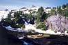
Hike an old road southwestward for about a quarter-mile. At this point there may be a backwater ford. For me it was thigh-deep for a twenty-foot crossing. Put your boots back on and continue on. In a few hundred more yards you will come to the river (North Fork Sauk). Now there used to be an 18-inch diameter log crossing, but it may be gone now. I've read reports where parties have crossed downstream. I blenched on this log crossing with my heavy pack on. A 10-ft fall into the bustling river below (the log crossing was over a particularly deep section of river) did not look too inviting. Instead, I walked upstream a hundred or more yards around a corner to this log complete with a 15-ft class 5 downclimb down its roots. After that log, I had to wade across two separate tributary streams just to get back to the trail. This also added about an hour to my approach, meaning I wouldn't make it all the way to the basin camp before dark. Yes, I had had enough wading so resolved to cross that spooky log on the return.
The trail then continues westward steadily climbing up a forested rib north of Cougar Creek. About 1.25 miles from the river at 3,100 ft, the trail crosses Cougar Creek right between two waterfalls. The upper one is attractive, the lower one destructive...to you if you should fall in the creek. There is no bridge (or was no bridge for me). I had to cross on a pile of slick logs. On the return I said I wasn't going to do that again. I resolved to jump across a narrow stretch of the creek just below the logs (but just above the lower waterfall!).
 |  |  |  |  |
Approach II (Don't get bogged down)
In another half-mile or so, the trail comes to a weird area of many streams descending through the trees. This one and this one were especially photoworthy. Above these (or was it below?), I had to do some more wading, as it appeared as if the streams were so numerous that they inundated the trail. The trail must cross Cougar Creek here a couple of times. The creek turns to the right (westward) at 3,480 ft.
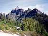
Continue up now on the south side of the creek for about a mile more to where it ends in a basin at 4,700 ft. Good camping here. There may be a bootpath that continues southward to the head of the basin. The slopes are comprised largely of heather, rock outcrops, and stands of trees--your typical sub-alpine basin. A prominent three-knuckled tower will appear above. This is Sloan Peak.
 |  |  |
Route (The Corkscrew)
Note: this route is so-named because it "corkscrews" to the summit in an inward trending spiral. The climb starts on the NNE, traverses the glacier to the SE corner, goes west on a broad ledge to the SW corner, then scrambles NE up the final rocks to the summit. Really the route is hook-shaped, but it has always been known as the Corkscrew Route, so I shall maintain convention.
From the basin, hike southward. There is a rock outcrop on the ridge above. This is Pt. 5852. You want to crest the ridge west of this point. The east side of it is cliffy on the other side. On your right, admire beautiful Bedal Peak. Once on the ridgecrest the Sloan Glacier will appear before you. It's not a steep glacier but it does contain crevasses. I was able to solo across it in July, but I do remember going around a couple of crevasses and stepping over a few narrow others. Normally, the upper (west) end of the glacier is easiest to cross. Your objective is the upper southwest corner of the glacier where the East and South faces of the summit cliffs form an arete. The glacier ends at a bench at this corner.
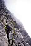
The bench is merely the east end of a broad, grassy ledge that extends across the South Face. There is a boot path. It's quite pretty. The ledge and path extend for about 300 yards to the South Buttress. There is a prominent horn on this buttress. In the vicinity of this horn, turn right and scramble up about 300 feet (class 3, some class 4 moves) to the rocky summit. The terrain is a mixture of gullies and rocky ribs. Hope it's not socked in up there for ya.
 |  |  |  |
My Summit Views (Or lack thereof)
 |  |  |
Return (Unscrew the Corkscrew)
Go back the way you came. Admire such views as this and this. Think about those wading sessions, the creek jump at the waterfall, and that fearsome log crossing. So what about me? What did I do? At the waterfall, I made the six-foot leap with heavy pack. I had about three inches to spare. On the way down to the log I kept repeating to myself "he who hesitates is lost, he who hesitates is lost." I said I would stop, take a picture, and then proceed across without delay. And this is what I did. And this was a good thing, for the moment I reached safety at the other side, a strong gust of wind cut across the log. It might have been enough to knock me off, but by that time I was standing over sandy beach. All I needed was a Corona to complete the scene.
 |  |  |  |  |
Essential Gear
Glacier gear: ice axe; crampons probably, but the glacier is not necessarily steep, so you may be able to avoid using them in early summer. In late summer and fall the glacier may be icy enough to warrant their use. A rope is needed if you're not comfortable crossing a low-angle glacier. It can be crossed solo.
Rock gear: helmet; possibly a rope and pro if you're not comfortable scrambling class 3 terrain that features a move or two or three of class 4.
JohnGilbert - Sep 26, 2006 10:27 pm - Hasn't voted
no logs to crossIn September 2006, we did not see any logs across the river. However, it was easy to wade across.
richdraves - Aug 2, 2023 7:22 pm - Hasn't voted
consider Bedal Creek approachI think the Bedal Creek approach is superior and increasingly popular. There are no creek crossings.