
|
|
Route |
|---|---|
|
|
40.19620°N / 106.1581°W |
|
|
Hiking, Mountaineering, Scrambling |
|
|
Summer, Fall |
|
|
Half a day |
|
|
Class 2 |
|
|
Overview
This is the standard route to the Corral Peaks since it is also the easiest and shortest route on the mountain. The route consist of following old logging roads, a steep faded trail and some scrambling over boulders.
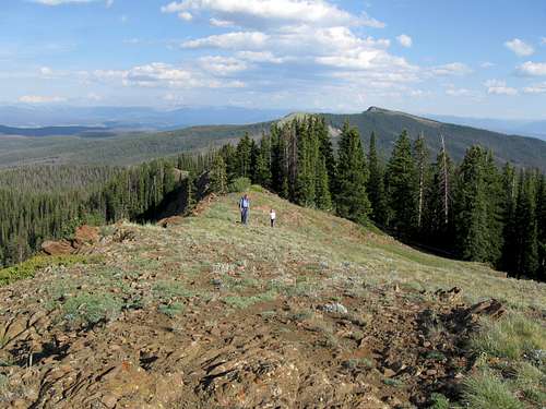 Kimberly and Shaylee on the south ridge of the South Corral Peak. Elk Mountain is background right.
Getting There
Via Parshall
This route offers the best road (at least in 2009) of the two driving routes to the trailhead, but the drive is longer.
Just west of Parshall and on Highway 40, turn north on County Road 21 (known as FR 112 higher up) between mile markers 194 and 195. Follow CR21/FR 112 for 15.5 miles to a road fork on the left (NW) which has a sign labeled “Corral Peaks” and is FR 112-1A. Either park here or follow the rough road 0.3 miles to the trailhead. This last 0.3 miles are considered to be a 4wd road, but we just made it in our minivan.
Note: As of 2023, the road is gated about a mile from the trailhead. It is unknown when or even if the road past the gate will ever be open again. In the meantime, plan to walk a mile or so to the old trailhead.
Via Granby/Windy Gap
Note: Due to washouts and the east Troublesome Fire, this road was closed as of 2023.
The road via this access is pretty good, but when it is wet it is extremely slippery and the route from Parshall is recommended if the weather is not dry.
On Highway 125 north of Windy Gap Reservoir (Highway 125 turns north of Highway 40 not too far west of Granby), turn west on FR 112 between mile markers 9 and 10. Follow FR 112 for 10 miles to a road on the right (NW) which has a sign labeled “Corral Peaks” and is FR 112-1A. Either park here or follow the rough road 0.3 miles to the trailhead.
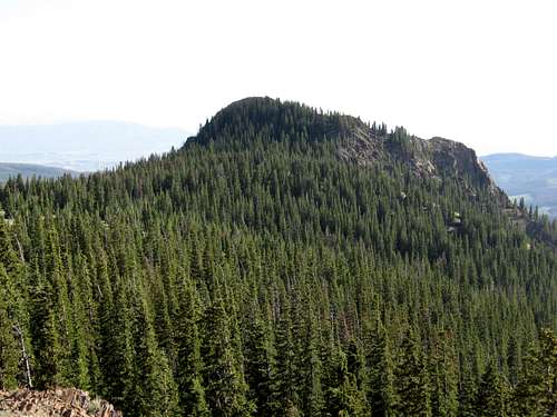 This is the South Corral Peak as seen from near the North Corral Peak. Both summits are forested to very near the summits, but the very summit area itself is barren on both peaks, which makes for some fine views.
Route Description
Right at the 4x4 trailhead there is a junction. Take the left fork and follow the old and closed logging road through the forest to the gentle east ridge of the Corral Peaks. The old logging road stays on the south side of the ridge before climbing to a meadow which is between the two Corral Peaks.
To climb the highest peak first, turn left (south) and follow the old logging road which gradually fades away into a trail. The trail is faint in places and it is steep with some deadfall to climb over, but it isn’t bad. The trail makes some short switchbacks and climbs the minor north ridge of South Corral Peak to the summit. There are some great views in all directions from the summit.
After enjoying the fine views, backtrack down the peak and back to the meadow located between the two peaks. There is a faint trail north of the meadow that heads towards the north summit, but it fades away after not very long. Continue through the trees and climb over a boulderfield to the south ridge of the North Corral Peak. Once on the ridge, follow it north to the summit. This summit has spectacular views as well.
From the north summit, descend down to the meadow and follow the ascent route back down to the trailhead. Even if you park at the FR 112/FR 112-1A the route is only 3.8 miles round trip (5.4 as of 2023 due to road closure). From the 4x4 trailhead (closed as of 2023), the route is 3.2 miles round trip and takes only a few hours. This is a nice after work climb or half day for residents of Grand County, but if you want to make the outing into a full day’s trip, you can easily climb Elk Mountain just to the south on the same day.
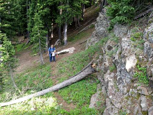 This is the upper section of the trail to the southern peak of the Corral Peaks. The trail is faded and steep, plus has some deadfall to cross, but it's the easiest route up the peak.
Essential Gear
Normal hiking gear is needed. There is no water available along the route, so bring plenty of drinking water.