
-
 4447 Hits
-
 71.06% Score
-
 1 Votes
|
|
Route |
|---|---|
|
|
46.39260°N / 13.86540°E |
|
|
Via Ferrata |
|
|
Summer, Fall |
|
|
Most of a day |
|
|
A medium hard ferrata |
|
|
Approach
We start the tour in Kot valley, where we can park on the altitude of some 950 m. From Mojstrana in Sava valley till the last parking place we have 1 h 45 min to walk (7 km).
Route Description
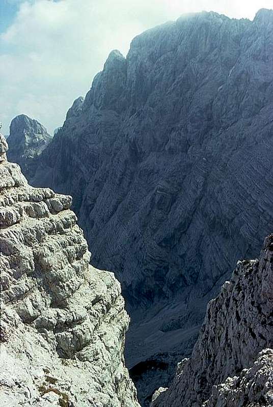
From the parking place on Lengarjev rovt (alpine meadow) we continue by the flat valley. When it finishes, the marked path ascends over the left slopes. Through forrest we gain altitude and reach a good water source. From there we continue crossing the slopes of Rjavina (in early summer there might be snow fields), allways towards the right. Now we are already above the forrests so nothing can prevent the magnificent view on the Rjavina north wall. On the other side of the valley, Spodnja Vrbanova špica catches our views. Below it, in the middle of the velley we spot Debeli kamen (Fat Stone, a distinct boulder), which we must reach over the more or less steep slopes. It stands on the edge, behind which a karst basin, named Pekel (Hell) lies. Till here we walk 3 hours.

While the main path to Staničev dom (hut) continues left, we turn in Pekel sharp right (towards the W). The path soon reaches steep rocks, crosses them and so we climb to the ridge of Vrbanove špice. The view on Cmir opens. From there we continue over steep grassy slopes and rocks, in many turns to the summit of Spodnja Vrbanova špica. From Pekel 1 hour.
Now the most beautiful part of the tour begins - crossing the high ridge to Visoka Vrbanova špica. First we go over big plates, then the ridge becomes sharper, full of gendarmes and notches. But the marks lead us safely over the ridge, avoiding the hardest points by ledges. In 1 h 30 min we reach the highest point. The best option to descend is towards Staničev dom (hut) - 15 min.
Essential Gear
0. General. 950 m to 2408 m, exposition NE, marked path below in the valley a medium hard, quite exposed ferrata to the summits.
1. Effort. 1500 m, 5 h.
2. Power. 3 - medium.
3. Psyche. 3 - medium.
4. Orientation. 1 - no difficulties.
Emergency Escape Option
Being on the ridge between Spodnja (Lower) and Visoka (High) Vrbanova špica, we have one option to escape into Pekel basin (the upper part of Kot valley). Where the ridge is lowest (more towards Visoka Vrbanova špica) we can descend from the notch by easy climbing into Pekel.
Of course, this can be (for any reason) also an option to get up to the ridge of Vrbanove špice.