
|
|
Route |
|---|---|
|
|
38.91000°N / 115.424°W |
|
|
Download GPX » View Route on Map |
|
|
Scrambling |
|
|
Summer |
|
|
A long day |
|
|
Class 3 |
|
|
most is class 2; class 5 if you get off-route |
|
|
Overview
This is the surest and easiest way to reach the summit of Currant Mountain, and can be linked with a near-ridge-walk to Duckwater Peak. The SE route requires some navigation skills (particularly in the trees at ~0.5 miles into the hike), but no climbing need be harder than class 2. However, the full loop will test your endurance. The accumulated elevation gain is over 5000' on rough, trackless terrain, with avalanche debris and trying talus.Getting There
These instructions describe the roads from Las Vegas, the nearest metropolitan center:From i15 and us95 intersection in Las Vegas:
-take i15 for 22 miles NNE
-then turn west on us93
-take us93 for 85.3 miles N
Near Crystal Springs is junction with 375/318
-take left toward Hiko
(375 and 318 are together for ~0.7 miles)
From that junction, travel N on 318
-take rte 318 for 111.5 miles N of the junction to intersection with rte 6
-Turn left (SW) on rte 6
-take rte 6 for 5.35 miles
-take right (W) turn onto White Pine Road (WPR)
-take WPR for 10.6 miles
-make left turn (SW) on rougher 2WD road ("Nfd 407"), take for 1.73 miles.
(2WD cars should park here)
-make right turn on 4WD road, immediately cross stream carefully (roughest part of road).
-travel ~0.4-0.5 miles up 4WD road and park before stream cut. As of July 2005, there were several deep cuts in the road near this point, making it impassable to all but ATVs. (NOTE: as of 2010, the road was MUCH improved and one could drive past the stream... info via cp0915.)
Here are a few waypoints, relative to WGS84, for critical turns in the drive:
37.529059, -115.219820, "LEAVE93"
37.532488, -115.232052, "LEAVE375"
38.997302, -115.124328, "TURN RTE 6"
38.930854, -115.173126, "TURNWHIPIR"
38.944105, -115.361272, "TURNFSR407"
38.923823, -115.378810, "TURN 4WD"
Those coming from California may wish to take us 6 all the way to the White Pine Road.
Route Description
The following description is keyed to this list of waypoints (relative to WGS84) and the 100k map at right below:38.921981, -115.386180, "PARKCAR"
38.920875, -115.395766, "LOGGINGRD1"
38.914200, -115.403819, "INGULLY1"
38.907788, -115.407636, "TURNGULLY2"
38.906543, -115.413598, "INGULLY2"
38.904823, -115.419778, "RIDGELINE"
38.908858, -115.423633, "DROPNEOFFR"
38.909850, -115.424418, "CURRANPEAK"
38.908932, -115.425776, "DROP2TALUS"
38.912459, -115.425387, "ON TALUS"
38.918069, -115.425839, "BACK2RIDGE"
38.923820, -115.423290, "PEAK11154"
38.929193, -115.426170, "COL DUCKW"
38.936571, -115.429399, "DUCKWAPEAK"
38.937577, -115.410467, "ROADNORTH"
38.933108, -115.409171, "ROADMIDDLE"
38.921281, -115.400923, "ROADSWITCH"
On the right below is a 1:100k map to place the waypoints in context; note the label for DROPNEOFFR is covered by the label for DROP2TALUS and the label for ROADSWITCH is partly covered by the label for LOGGINGRD1.
On the left is a 1:24k map that shows our actual GPS track. If you can upload tracks to your GPS, PLEASE USE the track at the top of this page. (Save the file to the desktop and change the extension to gpx if needed.)
 24k map |  100k map and waypoints |
Start at the stream (4WD parking area; waypoint PARKCAR). Normally this stream would be negotiable in a 4WD vehicle; however, all the rains and snow melt in 2005 have sharpened the banks, and for now the road remains impassable to all but ATVs. At this point, the valley is crossed by a buttress of rhyolitic rock, which made for a distinctive landmark (quite unusual, as most of the rocks one sees on this trip are limestones or lightly cooked shales). This stream will likely be your last water source for the day.
Travel W and WSW ~0.5 miles, then cut SW on an old logging road (waypoint LOGGINGRD1). (Curiously, this logging road isn't on the USGS map, but it IS on the MapSource Garmin map.) Eventually you will enter a gully; leave the faint road and head uphill in or near the gully (see map). The gully is an avalanche track, and may be full of downed trees; hence you may find easier travel on the south side, perhaps 50 to 100 feet vertically above. When we went up in 2005, the gully was still full of snow, which was occasionally quite dangerous, as one could posthole deep between fallen trees. However, the last two winters have been relatively dry.
From the logging road, you will see this rather unimpressive view of your potential route:
 View west from logging road |
(Jul-10-07 note: streeyyr reports trouble with this logging road. The point of the road is to ease travel until you can enter the gully; at that point you leave the faint road. If you use a GPS, follow the GPS waypoints above; if you don't, study the two maps above carefully, and remember your objective is to get to the gully, NOT to follow the logging road until it ends.)
Travel SW and then SSW till another smaller, steeper gully branches off to the right (TURNGULLY2). This 2nd gully is easy to miss; there is debris across the entrance. Ascend this 2nd gully. The route is nominally class 2 and mainly composed of smooth, denuded rock, but you may actually find it easier to walk right up the class 3 crack in the middle.
 Enter Gully 2 |  Penstemons |
Along the way, you may see fossils of pentamerid brachiopods in the limestone. Pass the waypoint “INGULLY2”. Shortly, you will cut right (NW) to reach the top of a cliff with impressive views of the east face of Currant:
 Currant East Face |
You are surrounded by bristlecone pines, atop a cliff several hundred feet tall. Continue west upslope; the rock is very loose, and larger parties should spread out laterally.
When you reach the waypoint “RIDGELINE”, the view NW will look like this:
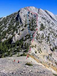 Currant SE “face” |  Profile SE “face” |
This is the SE “face” of Currant. At this point you can choose to take the western, blue route, which is a class 2 talus slog; or you can follow the rocky ridgeline (magenta route) with one slight caution: at the waypoint “DROPNEOFFR” you must downclimb east on a hidden, class 3 crack on the north side of a minor ridgelet. Now head WNW and then NNE to the top of the peak. As one can see from the profile above, the SE "face" is rather pathetic by Sierra standards; it is really just a ramp punctuated by a few cliff bands. However, those cliff bands must be respected, as they lead to 20-40' drops. Alternatively, you can choose to go even further west around all the rock and do a simple talus slog to the summit.
(Aug 2012 update: 11 friends (from our local hiking club) have since gone directly up the "face" (magenta route) and over the drop, following the GPS points, and reported the route was easy to follow. But in 2013, aobbard added:"I think the best, easiest and safest route up the final SE face of the peak is a variant of MoapaPk’s “magenta” route. Follow the solid rock path up as described. When you get to the class 3 (seems like 4?) downclimb, turn around, descend 25 ft on the steep ramp you just climbed to a bristlecone “bush” on your (descender's) left. Turn left almost 180 degrees in front of the bush, step easily to ground below rock outcrop. Re-climb 25 feet, bypassing the downclimb on climber’s right. Continue easily to summit." À chacun son goût; I scouted aobbard's alternative in 2005, but my friends preferred the direct downclimb. But I was younger and stupider then, and they were lazy.)
At the top of the peak, you can travel a short distance north on a very narrow and airy catwalk to another small summit:
I’m told that there is a way down the north side of the peak from here, but the route is very tricky; class 4 if you find the right ledges, class 5 if you don’t.
If you just intended to climb Currant, you can just retrace your steps. However, if you plan to go to Duckwater Peak, and you want to take a “safe” known route, you must descend off the west side of the peak. Since you should avoid walking off the 100’ cliffs that flank the west side of the summit, you must retrace your steps to waypoint “DROP2TALUS”, then carefully cut north. Now be prepared for the most miserable 0.6 miles of you hiking experience, as you contour north, aiming eventually for waypoint “BACK2RIDGE”, when you will finally stop side-hilling through loose rock. (Actually, it wasn’t that bad for me – I had boots with fairly stiff soles, which allowed me to “edge” in the talus, much as if I were skiing.)
Once you rejoin the ridge crest, you will head NNE to “PEAK11154”, crossing over some quasi-knife-edge territory. From here you can follow the obvious ridge down to “COL DUCKW”, then begin the climb to the nest summit. Seems easy, right?
Actually, for the lump that it seems in the distance, Duckwater holds a lot of surprises. You will travel over sharp ridges, and encounter about four false peaks on the way to the summit (DUCKWAPEAK).
Now the descent of Duckwater leaves some options. We went to the valley just SE of the peak, and descended 3000’ that way; our path is indicated by the red GPS line on the 1:24K map above. And having tried that route (in the gpx file), I tell you not to do the same; it was the most miserable 2 hours of the trip. You see, the valley is full of nasty talus leading to big dryfalls, and if you choose this route, you will spend much time finding ways around the falls. Worse, the valley was the site of avalanches some years ago; where the big trees were plucked away, now 5-20-year-old saplings spring up in impenetrable thickets.
I would suggest, as alternatives, you consider descent via either: 1) the magenta dashed line north of our (red) descent route, or 2) the magenta dashed line on the south of our (red) route (on the 1:24k map above). The south magenta dashed line was taken by Nick N, and he averred it was pretty good.
However you choose to descend, you will eventually hit a crude 4WD road at the east and north side of the range (ROADNORTH, if you descend the valley or the ridge to the north). The road is hidden in a thicket at the north end, and is actually fairly easy to miss; as you move farther south, the road is more in the open, and more obvious. Some of the best views of the range are on this road.
You can follow the road back, through points ROADMIDDLE and ROADSWITCH, eventually back to your car. You can use the rhyolite buttress as a landmark.
The route to Currant, from the SE, can be done entirely class 2. If you plan anything more interesting, take at least 50' rope or 2800-lb webbing.
The top ridge is very cold and exposed in bad weather.
Gerry Roach (yes, the same Gerry Roach) describes a slightly different way to climb Currant from the SE, with an easier solution to the SE "face":
Gerry's Approach to Currant
In Cohen's book "A Garden of Bristlecones," he claims the county was actually named after the limber pines. Scotty of SP has suggested the bristlecones were regarded as "white pines" by early explorers.
2) There seem to be some currants on Currant Mountain, on the SE side -- at least, there are Ribes genus members, be they gooseberries or currants.
3) This mountain, and Streeyyr's entry, were what convinced me of the usefulness of summitpost. Streeyyr's description (in his 1st trip report) was invaluable in convincing me to try another approach; else I would have gone the way he went. His photos convinced me I should not underestimate this peak.:
 View SE, below peak |
At the top of the peak, you can travel a short distance north on a very narrow and airy catwalk to another small summit:
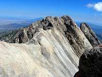 Catwalk to North of Peak |
I’m told that there is a way down the north side of the peak from here, but the route is very tricky; class 4 if you find the right ledges, class 5 if you don’t.
If you just intended to climb Currant, you can just retrace your steps. However, if you plan to go to Duckwater Peak, and you want to take a “safe” known route, you must descend off the west side of the peak. Since you should avoid walking off the 100’ cliffs that flank the west side of the summit, you must retrace your steps to waypoint “DROP2TALUS”, then carefully cut north. Now be prepared for the most miserable 0.6 miles of you hiking experience, as you contour north, aiming eventually for waypoint “BACK2RIDGE”, when you will finally stop side-hilling through loose rock. (Actually, it wasn’t that bad for me – I had boots with fairly stiff soles, which allowed me to “edge” in the talus, much as if I were skiing.)
Once you rejoin the ridge crest, you will head NNE to “PEAK11154”, crossing over some quasi-knife-edge territory. From here you can follow the obvious ridge down to “COL DUCKW”, then begin the climb to the nest summit. Seems easy, right?
 Columbine on W Side Talus | 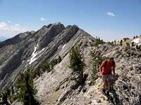 View S; Rejoin Ridge, Start Knife Edge |
Actually, for the lump that it seems in the distance, Duckwater holds a lot of surprises. You will travel over sharp ridges, and encounter about four false peaks on the way to the summit (DUCKWAPEAK).
 View North from Duckwater | 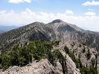 View South from Duckwater |
Now the descent of Duckwater leaves some options. We went to the valley just SE of the peak, and descended 3000’ that way; our path is indicated by the red GPS line on the 1:24K map above. And having tried that route (in the gpx file), I tell you not to do the same; it was the most miserable 2 hours of the trip. You see, the valley is full of nasty talus leading to big dryfalls, and if you choose this route, you will spend much time finding ways around the falls. Worse, the valley was the site of avalanches some years ago; where the big trees were plucked away, now 5-20-year-old saplings spring up in impenetrable thickets.
I would suggest, as alternatives, you consider descent via either: 1) the magenta dashed line north of our (red) descent route, or 2) the magenta dashed line on the south of our (red) route (on the 1:24k map above). The south magenta dashed line was taken by Nick N, and he averred it was pretty good.
However you choose to descend, you will eventually hit a crude 4WD road at the east and north side of the range (ROADNORTH, if you descend the valley or the ridge to the north). The road is hidden in a thicket at the north end, and is actually fairly easy to miss; as you move farther south, the road is more in the open, and more obvious. Some of the best views of the range are on this road.
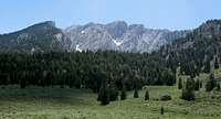 View West to Currant Range from Old Road |
You can follow the road back, through points ROADMIDDLE and ROADSWITCH, eventually back to your car. You can use the rhyolite buttress as a landmark.
Essential Gear
PLENTY of water. If you do the loop, you will probably gain 5000'. After the first stream crossing, there is no water en route (except snow in early months), and the Nevada sun is merciless.The route to Currant, from the SE, can be done entirely class 2. If you plan anything more interesting, take at least 50' rope or 2800-lb webbing.
The top ridge is very cold and exposed in bad weather.
External Links
Where we camped, there is room for one car and perhaps two tents, so a larger party might do well to stay at the maintained White River campsites several miles back. (There is also an area that looks suitable for camping on the N side of the last 2WD road, perhaps 0.8 miles on Nfd 407 from the junction White Pine Road.)Gerry Roach (yes, the same Gerry Roach) describes a slightly different way to climb Currant from the SE, with an easier solution to the SE "face":
Gerry's Approach to Currant
Fun Facts about "The White Pine Mountains"
1) There are no "white pines" (Pinus monticola) in these mountains, to my knowledge. There are, however, lots of white firs. The needles of the firs are rather flat and flexible (compared to spruces), and the light-colored bark often has sap blisters as seen in balsam firs. I tried in vain to see cone spikes on standing trees.In Cohen's book "A Garden of Bristlecones," he claims the county was actually named after the limber pines. Scotty of SP has suggested the bristlecones were regarded as "white pines" by early explorers.
2) There seem to be some currants on Currant Mountain, on the SE side -- at least, there are Ribes genus members, be they gooseberries or currants.
3) This mountain, and Streeyyr's entry, were what convinced me of the usefulness of summitpost. Streeyyr's description (in his 1st trip report) was invaluable in convincing me to try another approach; else I would have gone the way he went. His photos convinced me I should not underestimate this peak.: