![Mount Dewey, Sunset]() Mount Dewey, our other objective
Mount Dewey, our other objectiveThe Mountain
Tim was right and I was wrong. Well, actually, I was right and Tim was wrong before Tim was right and I was wrong.
Sorry to get all
John Kerry on you there. We’ll address all that in time. But first, we'll have some route details since as of yet there is no SP page for Dead Indian Peak, then the story, and, finally, the right and the wrong.
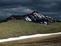
One of the highest mountains in the beautiful Sunlight Basin area of the Northern Absarokas, Dead Indian Peak is impressive from many angles. Its tiny, pointed summit catches the eye and makes it easy to spot, and no other peak in the vicinity has such a distinctive profile. In fact, few other peaks in Greater Yellowstone are as spectacular in form as Dead Indian Peak is. Most people probably see the peak from Dead Indian Summit along the Chief Joseph Memorial Highway or from the Beartooth Highway, but mountaineers recognize its shape from many different directions.
Climbing Dead Indian Peak is a serious endeavor. The peak is deep in a wilderness known for its difficult terrain and abundant grizzlies. It has a Class 3 summit and significant exposure. Most of the approach is an off-trail one, and the trail portion is on a trail that is in pretty good shape but does not appear on maps, which means there is not heavy usage out here, which in turn means, considering that cell signals are weak as well, that climbers are probably going to have to rely solely on themselves if something goes wrong.
Route Information and Misinformation
Today, climbers wishing to use published information when climbing this mountain are likely to rely on Thomas Turiano’s
Select Peaks of Greater Yellowstone. There are, however, some shortcomings to his route description (about which I've since contacted him-- to his great credit, he was cool about it, unlike how some others might ne). Turiano has climbed more mountains than I have and may in fact be a better climber, and I am not trying to personally slam him. I own his book, enjoy it, and have recommended it to many people, and most of his route descriptions are quite good, but when he climbed Dead Indian, he used a different route (from Mount Dewey and upper Dead Indian Creek), and the "standard" route described in the book is based on information from others instead of his firsthand experience.
Before I proceed, I want to say that I am not someone who wants or needs my hand held by a route description. Many peaks I climb nowadays have no published information on them; I actually prefer studying maps, photos, and views and finding my own way up a mountain. But I do think that published information, however much there is, should be as accurate as possible, and preferably based on firsthand experience.
So…
First, in directions for reaching the trailhead, there is no mention of a crossing of Sunlight Creek. Turiano says to drive the Sunlight Basin road for 13 miles and then turn left onto FR 182. This is true enough, and although there was no sign at the turnoff in July 2010, there was a sign shortly along the road.
The omission about Sunlight Creek is significant. This stream is no mere trickle. While it’s possible that in late August it is just a splash to cross, in early July it was deep and swift; just a few feet from the bank, the bottom was no longer visible. Even with high clearance and four-wheel-drive, I was not willing to take on this crossing, and fording on foot looked unsafe as well. Instead, Tim and I parked near the ford, hiked west a little to a bridge leading to a ranch gate, crossed the bridge, and skirted the fence line until we reached FR 182. It was about a mile and a half of hiking from our parking spot to road’s end at Gravelbar Creek.
Also, the directions make it sound as though FR 182 begins where Gravelbar Creek joins Sunlight Creek. That is not the case; the confluence is a short distance east. It's not that big a deal, though, once you realize that the road is not parallel to the creek.
Next, there is not a mention that at road’s end, one must cross Gravelbar Creek to pick up the trail. To me, it looked as though crossing the creek right away made sense, but Tim wanted to look for a better spot to cross, so we headed upstream on its west side for a bit before being forced by terrain to cross over, where we did find the trail (and it does begin directly across from road’s end, as we found the next day). Again, not a terribly big deal, but this more precise description might save people some time and effort.
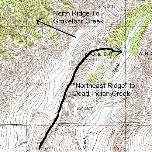
The route description goes on to say this: “Follow the Gravelbar Creek trail for some distance. Then, leave the trail and ascend a spur for 2,500 vertical feet to the main ridge separating Sunlight Basin from Dead Indian Creek.”
“Some distance” doesn't aid the climber too much because there are several spurs from Gravelbar Creek up to the alpine ridges, and each has its own character and difficulty level. Tim and I chose one that looked less awful than the others. We left the trail about 4.5 miles from road’s end, at approximately 8400’, and then ascended over 2500’ in around 1.5 mi. More than half was a very steep bushwhack, and there was a lot of dense deadfall to deal with as well. When we finally reached the alpine ridges above, where there were spectacular views of Dead Indian Peak and Mount Dewey that made all the suffering worth it, Dead Indian Peak was no more than two miles away, probably significantly less than that.
In retrospect, we realized we should have taken a different spur up. During the trail hike, there were two times that the trail rose to a crest and then dropped back to the stream level. From the second rise, there is a spur leading to the alpine ridges, and that spur looks longer, gentler, and more open than the one we took. There appears to be some tricky scrambling up high, and the overall route may be a little longer, but it seems to be a better way to go. In fact, after studying maps closely since and looking at Turiano's route diagram (it is not on a topo map and is not detailed enough to use as a primary source; it is instead a generalized diagram for several peaks in the area), I believe this other spur is probably the one he refers to, and using it would put the route closer to his descriptions and his distance estimate.
Update: I did use that spur in 2011. It works but has its own set of issues. Please see the main page for details.
Just below the alpine ridge, on the other side, we found beautiful grassy meadows, and we camped there with 5-star views of the peaks we wanted to climb the next day. It was also there that we discovered another problem with the book description, and a potentially serious one at that.
In the book, Turiano talks of ascending the north ridge, and there is a photograph taken from Mount Dewey that shows the ridge and his route up it (Turiano descended from Dewey, dropped into the basin at the head of Dead Indian Creek, and ascended the eastern face of Dead Indian Peak until gaining the ridge).
The problem is that this ridge is
not the north ridge; it is really a northeastern ridge that is at times only narrowly separated from the north ridge but which is clearly distinct from it, divided by a drainage, albeit a shallow one. From one point on this ridge, it would be easy to descend to the drainage and then ascend the true north ridge, which is indeed very long and does indeed divide Sunlight Basin from Dead Indian Creek. Later, the ridge bends east to reach Elkhorn Peak (where a spur from Gravelbar Creek meets the ridge at this eastward bend is where I suspect Turiano intends for the climber to gain the alpine ridge leading to Dead Indian's summit).
The ridge that Tim and I gained is the real north ridge. This is not such a big deal for someone beginning and ending at Gravelbar Creek; the two ridges both access the summit nipple at about the same place. But if someone were approaching from the south via Big Creek, for example, and relying on the book route for the descent, he might follow the wrong ridge down and end up several miles and a full drainage off course, finding himself in the drainage of Dead Indian Creek rather than that of Gravelbar Creek. One would hope that he would notice and adjust before it got that far, since the ridge would force him to descend northeast and the way to Gravelbar Creek is to descend west, but the possibility of going seriously off course does exist.
It is, of course, ultimately the climber’s responsibility to read the land and maps correctly. If you're the type who relies solely on a guidebook and would blame the author over a wrong turn, you probably shouldn't be straying from the maintained trails in the first place.
![Dead Indian Peak]()
![Ridges of Dead Indian Peak]()
There is one other mistake in the route description, but this is actually a good mistake: instead of being 12 miles to the summit, it is more like 8 or 9, or at least it is the way we went. Going 24 miles and 5000+ feet in one day is too much for most people, especially considering the difficulty of the terrain. I know people climb Mount Whitney and Kings Peak, which are both in the same neighborhood when it comes to distance and elevation gain in a day (though each has a good trail either all the way up or well more than half the way in-- I have done so on Whitney), using the hours of darkness to their advantage. Because of the grizzlies, though, it would be extremely unwise to be traveling in the dark out in the North Absaroka Wilderness, meaning you really only have from dawn until dusk for Dead Indian Peak if making a day trip of it. It was miserable hauling a full backpack from Gravelbar Creek up to the north ridge, and given another crack at the peak, I will almost definitely do it as a day climb. But reducing it to 18 makes it much more feasible as a day trip.
I wish I could comment on the climbing conditions to get to the actual summit, but weather thwarted our plans, and that’s the subject of the rest of this story.
The Trip-- Unwelcome Snow
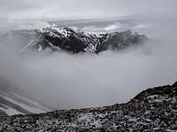
As Tim and I made the grueling ascent from Gravelbar Creek to timberline, we frequently paused to complain and suck air. But we also kept an eye on conditions. To the north, people in the Beartooth Mountains were probably not having the best day ever, for there was a thick black curtain over that range that looked like thunder, snow, or both. And it was slowly moving south, our way; Pilot and Index Peaks, two landmark Absaroka summits north of us, had gradually disappeared from view.
|
|
|
![Storms over the Beartooths]() Bad day in the neighborhood... Bad day in the neighborhood... |
(Photos above by musicman82)
Although the warm sun left us, which was a blessing of sorts since we were sweating so much during the off-trail bushwhack, the weather held for us all that day.
And that’s the reason for the first chance I’d like to have back.
On most long days in the mountains, I get a second wind at some point. After an hour or two of rest, I suddenly feel fresh again. This is why I frequently do a climb super-early in the morning and then do something shorter but still worthwhile late in the afternoon, which is generally my favorite time of day to be in the mountains. When I go backpacking, I like to plan an early-afternoon arrival at my camping destination so that I can set up camp, sit on my can and read a book for a while, and then go out to do something before sunset.
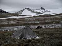
It was, I think, around 6 P.M. when we reached the crest of the north ridge, and camp, including the burying of our beers in a snowbank, was set up in less than an hour. After cresting that ridge and seeing Dead Indian Peak so close-- and more spectacular than I had imagined it would be-- I had a strong urge to climb it that evening just in case the weather went on us the next day, and I felt more than up to it; that view had revived my spirits and my energy. Only about two hours of daylight remained, but I was certain I could make the summit and be down before dark, and the hike back to the tent would not have been a big deal.
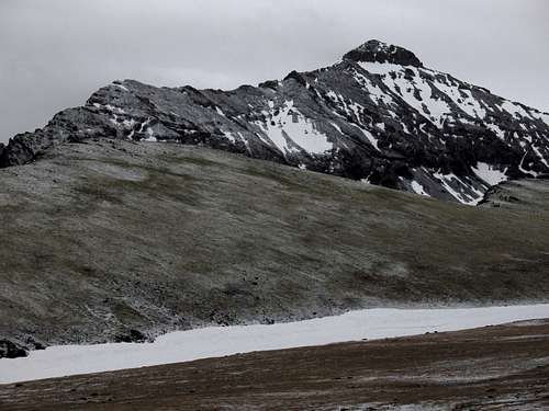
![Mount Dewey and Dead Indian Peak]() Finally seeing this made all the suffering worth it.
Finally seeing this made all the suffering worth it.
For Tim, though, it was his first big day in the mountains and at altitude that summer (it was my seventh consecutive one), and he wasn’t interested in a summit push that day. Despite being a little disappointed, I was by no means crushed after all the rigors of the day, and I also thought it would have been uncool if I’d gone on alone, especially since Tim had been really psyched about this peak for a long time, and longer than I had been at that.
Mistake #1-- Now I wish I’d gone up.
During the night, winds picked up and the storm moved in; I could hear snow falling against my tent. In the morning, the ground was white with a dusting, and very light snow was still coming down, but the peaks were visible. Tim was ready to go after our wakeup time, 5 o’clock, but I suggested waiting a bit to see if what appeared to be a clearing trend actually was one. Our plan was to do more than just climb Dead Indian; from that summit we wanted to try the ridge traverse to Mount Dewey (conditions unknown but likely Class 4 or low Class 5 on bad rock), descend to Dead Indian Creek, and then regain the ridges north of Dead Indian Peak and return to camp to spend a second night out. So it made sense to see a clear improvement in the weather before committing ourselves to such a big day.
![Camp at Sunset]() Sunset Sunset |
![Camp the Next Morning]() "Sunrise" "Sunrise" |
And then we went out. Before long, the snow picked up, and by the time we got close to the summit, it was invisible. We waited some more. Conditions worsened. We went back to camp.
Mistake #2-- We should have gone out at wakeup time instead of waiting and watching the weather. Even though we never would have been able to fulfill our plans for the day, we probably would have gotten up Dead Indian and still seen something.
Mistake #3-- Instead of going back, we should have gone ahead and climbed in the bad conditions. I’ve climbed in worse.
Now I have to go back.
![Tim ponders the route.]() Tim starting out
Tim starting out
When we got back to camp, Tim said he figured this was one of those mountain storms that pisses you off for a few hours and then moves on. Pessimist that I am, I said I thought there was a big, nasty system sitting over the region and that if conditions improved at all that day, it wouldn’t be until late in the afternoon at best. I told Tim I’d seen this kind of thing before and had no faith that it was getting better anytime soon.
That was around, oh, 9 or 10 o’clock.
We went back to our respective tents. Yes, we had separate tents even though we could have saved a little weight by using just one. As I told Tim, I hate sleeping in a tent to begin with, and I really only want to share a tent with someone I want to touch, such as my wife. Tim is a nice guy and all, but we hadn’t been in the wilderness long enough to entertain such considerations, if you know what I mean.
There is something about being warm and dry while snow comes down just inches away that is incredibly peaceful and cozy. The guy who hates sleeping on the ground was happy as a pig in shit alternately reading, dozing, and doing crossword puzzles in his zero-degree mummy bag into early afternoon. Hell, he would have been happy doing that all day.
About 10 yards away, though, it was a different case. Unbeknownst to me, Tim was having some issues with tent leakage. The poor guy held on as long as he could before calling out that we should abandon the plan and get the hell out. He was concerned that for all we knew, we were facing a major storm that could dump a foot of snow and make conditions truly awful and dangerous. That didn’t worry me too much because I felt prepared to deal with such conditions, but he did have a point that it had gotten colder and the snow was starting to accumulate.
Leaving wasn’t what I wanted to do, and I said something to that effect. Toasty as I was, I was still ready to wait all day if I had to. But I got to thinking that when you’re with someone else and that someone else is no longer comfortable with the situation, you should defer to him rather than push. So that’s what I did.
I wasn’t happy about it, though, and as I went from warm and dry to cold, numb, and wet, I grumbled something about wanting the record to show I thought this was a mistake. It didn’t help that the liner pulled out from my gloves and I was having a hell of a time getting it back in-- the reason for the numbness. And that’s when I found out about the leaking tent.
Tim-- I am sorry I was sitting there so nonchalantly while you were taking in water. Please don’t ever again think you need to keep something like that from me or anyone else just so you won't spoil the day. I’ve dealt with a leaking tent, even a floating tent, before, and it sucked.
So we left. Of course, the snow abated very soon after we took off and a little clearing began. We waited a bit, or I should say I stubbornly insisted we wait a bit, but the dense cover came back soon and we admitted defeat.
![Defeat]() Disgust... Disgust... |
|
(Photos above by musicman82)
Heading down, we took a different spur that we had studied the day before and thought seemed easier than the one we used going up. Our mistake, and it was my fault, was going too low. As the faux clearing went on, I spotted a somewhat-level spot with some trees around it that would have made for a decent campsite and also a reasonable base for a late-afternoon or early-morning attempt on Dead Indian. We headed down there and waited a bit, but after resigning ourselves to the fact that the weather wasn’t going to smile on us, we agreed to continue our retreat. The “good” spur was the next one east, but reaching it from our spot would have required reclimbing, and since I hate that, we continued our descent.
There is not much to tell of things after that. The descent sucked-- although the snow had changed to rain higher up and the rain had mostly stopped, everything was wet and the terrain was challenging, but we got back to the car without any major hassles. And we also saw a nice gorge and some waterfalls that I'll bet only a handful of other people have ever seen.
Naturally, major clearing began right about when we began driving out. But up at Dead Indian Pass, we could see that Dead Indian Peak and its neighbors were still cloaked in gray. And it was the same story the next morning, which gave us some bittersweet satisfaction.
Right and Wrong
We’re going back next year, and it will be a day climb.
So you see, I was right and Tim was wrong before Tim was right and I was wrong. I was right that conditions weren’t going to improve. But Tim was right that we needed to get out. If I hadn’t given in, I’d still be hearing crap about it.
Next year, though, we’re going up no matter what hell the mountain gods send our way.
![Dead Indian Peak]() See you next year...
See you next year...


Comments
Post a Comment