
-
 6208 Hits
-
 79.04% Score
-
 10 Votes
|
|
Route |
|---|---|
|
|
32.20920°N / 111.1061°W |
|
|
Hiking, Scrambling |
|
|
Spring, Fall, Winter |
|
|
Half a day |
|
|
Class 3 |
|
|
Overview
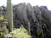
 Eastern slopes of Golden Gate Mountain, showing typical off-trail conditions in this area
Why settle for one desert peak when you can have two? This nice desert route combines on-trail efficiency with off-trail exploration, taking in two dynamite desert peaks in one outing. This route is for solid navigators comfortable going off-trail in rocky, prickly Sonoran desert terrain.
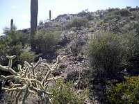
Note: This area is a virtual rabbit warren of official trails, semi-official trails, social paths and animal paths. Carry a good topographic map and rely more on your navigational skills and wit than on following existing paths.
Getting There
 Looking up at Golden Gate
 Yetman Trail
• From I-19, exit west to Ajo
• Turn north on Kinney Road
• Follow Kinney Road into Tucson Mountain Park
• Turn east/right onto Gates Pass Road
• Follow Gates Pass Road for less than 2 miles to a parking turnout on the south side of the road (where the road dips strongly south).
If you get to Gates Pass, you have gone too far
Route Description

 Diagram - northeast slopes of Golden Gate Mountain
To Golden Gate Mountain
It is only about 1 mile from the parking area to the summit of Golden Gate Mountain, but most of the route is off-trail and through rugged desert terrain.• From the parking area described above, head south on the Yetman Trail for less than ¼ mile.
• Depart the wide trail and ascend the northeast slopes of Golden Gate Mountain.
• The off-trail section begins gentle, on low-angle, less-rocky terrain while on the lower apron of the northeastern slopes of Golden Gate Mountain.
• About 2/3 of the way up the slope the terrain becomes rockier and steeper.
• Gradually depart the ridge and enter the gully, where a faint use trail begins to appear now and then.
• Continue ascending toward a low rock wall on the summit ridge. Head left/south at this wall, which will take you to the saddle between the summits.
• Continue south toward the summit of Golden Gate Mountain. Reaching the summit requires easy scrambling (YDS 2+ - 3) on terrain with minimal exposure.
Enjoy the views from the rocky top!
To “Bren’s Better”
• Descend the northeast slopes of Golden Gate Mountain toward the Yetman Trail for roughly ½ mile.• Turn south on the Yetman Trail. Follow the Yetman trail roughly 1/3 mile, descending gradually from the highpoint of the Yetman Trail saddle between Golden Gate Mountain and “Bren’s Better.”
• Begin scoping for a faint social trail across a wash that will carry you to a low point on a ridge extending east from “Bren’s Better.” You may or may not pick up the social path right away – be prepared to bushwhack.
• Approximately ½ mile after departing the Yetman Trail, you will reach the highpoint of the ridge radiating out from “Bren’s Better.” At this point a surprisingly well-defined trail that carries you into the amphitheater on the east side of “Bren’s Better” will become apparent.
• Follow this trail as it first descends into the amphitheater, then begins to re-ascend the amphitheater heading roughly northwest. (This is a beautiful and fascinating place that feels miles away from the city of Tucson!)
• As you ascend, the trail will become fainter but cairns will appear. Carefully follow the cairns as they loop you around the northeast side of “Bren’s.”
• The cairned route continues up a faint ridge. The cairned path is faint and meandering, but worth following to ease passage through the desert. Carefully following the cairns will put you on the summit of “Bren’s Better.” Be sure to explore all of the highpoints.
Back to the Parking Area
• Carefully descend the cairned route, then descend the faint trail into the amphitheater.• The trail becomes stronger as the route re-ascends out of the amphitheater to the ridge line. From here, a social trail descends toward the Yetman Trail, though the trail gets fainter and fainter as the Yetman Trail nears. Depending on your tracking skills and your tolerance for Cholla whacking, you may finally chuck trying to follow the social route and simply bushwhack your way to the visible Yetman Trail.
• Follow the Yetman Trail for less than ¾ mile back to the parking area.
Key Route Photos
Golden Gate Eastern slopes
 Lower northeastern slopes of Golden Gate Lower northeastern slopes of Golden Gate |  Nearing the saddle between highpoints Nearing the saddle between highpoints |
Golden Gate Summit Block
 Final push to Golden Gate summit Final push to Golden Gate summit |  Easy scramble to summit of Golden Gate Easy scramble to summit of Golden Gate |  Descending Golden Gate Mountain Descending Golden Gate Mountain |
"Bren's Better"
 Cairned route on "Bren's Better" Cairned route on "Bren's Better" |  "Bren's Better" from the east "Bren's Better" from the east |
Essential Gear
 Desert Pom Poms on rockymountaindiva's boots
• Trail map (Trails Illustrated #237 – Saguaro National Park would meet most needs)
• Scrambling gloves (gardening gloves would do in a pinch)
• Clothing to protect your skin from rocks abrasions and vampire desert plants (including long pants and long sleeves, though gaiters may be useful as well).
• Sunscreen
• Abundant drinking water and salty snacks