Comments
No comments posted yet.

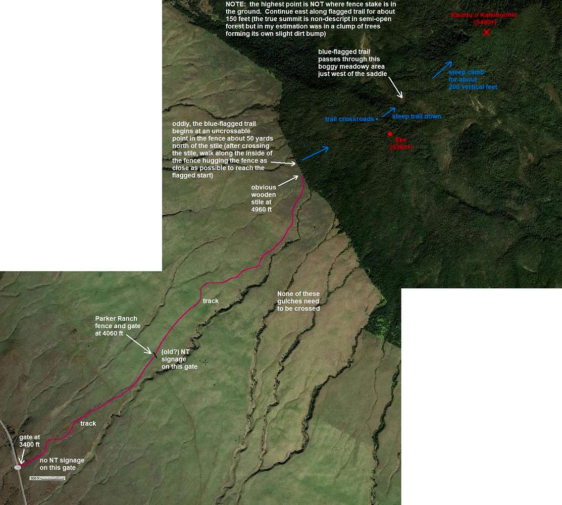
Note: IT MAY BE BETTER TO VIEW THE FULL-SIZE IMAGE TO READ THE ANNOTATIONS.
This is the most expedient route from the highway to the rainforest stile. Approximately 1500 feet of gain from car to stile. It took me an hour. No gulches needed to be crossed. The route follows a track all the way, with the tread of the track getting better the higher you go. Walking the ground not in the track tread would be more exasperating due to the spongy grass.
For some unknown reason, the blue-flagged route into the rainforest does not start at the stile. So on the way into the rainforest I missed the trail entirely. Fortunately for me I had completely dry conditions (7/3/19). I simply cross-countried it (hardly worse than my typical Washington dumpster dive in terms of bushwhacking) to the summit of Eke whereupon I found the flagged trail that leads NW to the blue-flagged cross-roads.
On the way back to the stile after summiting, I stayed on the blue-flagged trail more consistently though I did lose it for a 100 yards or so. When I finally got back on it, it was really easy to follow all the way to where it irrupts into the open at the ranch land fence. Oddly, there is no easy way to cross the fence here. I could have climbed the fence but it was easier just to hug along the fenceline, being careful not to snag myself on the barbwire, for about 50 yards to get back to the fence. There is a bit of a path along the fence but it's open enough you can duck and weave as necessary.
As for the trail to the summit of Kaumu o Kaleihoohie, from the blue-flagged cross-roads on the Eke ridgeline, continue on the blue-flagged trail the bears directly for Kaumu. (From here if the weather is good you can see forested Kaumu across the valley.) The trail soon begins a steep (for the area) descent to the saddle area below. Follow flagging. The trail dumps out into a boggy meadowy area just west of the saddle. Continue north, being mindful of boot-sucking muddy spots on the trail. Beyond the meadow the trail descends slightly to cross a creek. There's a handy log to avoid flopping and plopping in the mud.
After the creek, the trail steepens but is fairly easy to follow. If you go the wrong way, simply back-track where you came, looking for the last flag you saw, then look around. Flagging is sometimes high, sometimes low, and sometimes on the ground. Once on the final ridge it seems like there are other trails and even some orange flagging. Don't be tempted by the shiny orange. Even some small blue-flagged tags got me going the wrong way on descent and I had to contour across a steep slope/gully to reset to the trail. So this area I found to be the most difficult to keep keen on where the trail is.
The trail comes up to a metal fence stake with flagging wrapped around the top. This stake is NOT at the summit. You have to continue east about 50 yards to reach the highest contour then wander around in the semi-open forest to find what suits you as the highest point.
It took me about 3 hours to make the summit (2 hours, 40 minutes of moving), with 15 minutes at the top, and 2 hours to get back to the car. From the stile to the car took me 35 minutes. But I had dry conditions (no moisture at all on the plants). If it were wet conditions I can bet I'd have gone much slower through the rainforest.
--Paul


