
-
 5718 Hits
-
 80.49% Score
-
 12 Votes
|
|
Mountain/Rock |
|---|---|
|
|
49.22572°N / 7.90817°E |
|
|
Sport Climbing, Toprope, Scrambling |
|
|
Spring, Summer, Fall |
|
|
915 ft / 279 m |
|
|
Overview
 South face of the central cliff of Drei Felsen South face of the central cliff of Drei Felsen |
When travelling to the Südpfalz / Wasgau Climbing Region you most likely will drive along B10, the main access road in the north of the area. Coming from Annweiler in the east you drive through three or four tunnels until you reach a valley which stretches for some 3 km between the villages of Rinnthal and Wilgartswiesen. Here on the north slopes of the valley - though almost hidden completely from sight for the east-west traveller - you can find a number of perfect sandstone climbing cliffs. Only when you return driving east again will you see the tops of three rocks - the prosaically named Drei Felsen.
Most parts of the cliffs are hidden beneath the forest canopy - whether seen from the valley floor or from their respective tops. Vegetation always gets in the way. Only from their bases directly beneath the south faces can you take in the real size and form of the crags. They offer just about everything - numerous routes between difficulties 1 and 9, smooth surfaces, caves, overhangs, honeycomb structures, ledges, cracks and much more. You also can scramble up the steep slopes between the cliffs to the place in their backs where they almost combine. Getting back to their summits up front, however, requires stepping across the exposed summit plateaus across cracks and chasms while negotiating trees and bushes in between.
The Drei Felsen cliffs are easily accessible. A bike road connects the two villages and you need about 30min from Wilgartswiesen while the closer Rinnthal is ony 15min away. A path leads to the central (and most impressive) concavely formed rock leading on to the eastern rock south-east face. The western rock can be reached by scrambling up a very steep slope across soft and deep soil. Tread carefully since deep ruts have been created by frequent use.
Set aside by several hundred metres you can find two further cliffs - Wilgartisplatte and Wilgartisburg (also Wilgartaburg). The latter is an old medevial castle ruin of which only a closed well and some foundations for roof beams and staircases remain. Both crags also offer good climbing possibilities if the other three are too crowded.
 |
 |
 |
 |
 |
 |
 |
Climbing Routes to Drei Felsen
All three cliffs offer a good number of different climbing routes and so do the neighbouring cliffs Wilgartisplatte and Wilgartisburg. The most interesting one is probably the central rock of Drei Felsen with its concave overhanging south face.Rather than reprinting the copyrighted information from the site of the Vereinigung Pfälzer Kletterer I link to their routes database directly with some summary info. Here is the link to the complete database.
| Feature | Routes link | Summary | Thumb |
| Drei Türme, Ostgipfel | Ostgipfel | 19 routes with variations ranging from 1 - 8- |  |
| Drei Türme, Mittelgipfel | Mittelgipfel | 14 routes with variations ranging from 4+ - 9 |  |
| Drei Türme Westgipfel | Westgipfel | 13 routes with variations ranging from 3 - 8 |  |
| Wilgartisplatte | Wilgartisplatte | 13 routes with variations ranging from 5+ - 7+ | 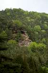 |
| Wilgartisburg, Vorgipfel | Vorgipfel | 6 routes with variations ranging from 2 / 7]- |  |
| Wilgartisburg, Hauptgipfel | Hauptgipfel | 2 routes 2 and 7- |  |
Getting There
 Wilgartisburg "forecastle"
Drei Felsen are located above the village of Rinnthal, directly above the main access road, B10. The closest airports are at Frankfurt and Stuttgart so the itineraries start there too.
From Frankfurt
There are two possible routes which both take equally long- Via Ludwigshafen
- From Frankfurt take motorway A5 southward to Darmstadt.
- There change to A67 south.
- At Viernheimer Dreieck turn onto A6 west. Leav
- e it at Frankenthaler Kreuz for A61 south.
- At Mutterstädter Kreuz take A65 south until you reach Landau.
- At Landau turn on B10 west.
- Either leave B10 at Rinnthal or Wilgartswiesen and park your car in either village
- Look for the bike road between the villages and hike along.
- To the west of Drei Felsen a dirt road turns off north (sign "Rundweg"), immediately turning east to the base of the cliffs. Look closely for a path heading up the slope to the base of the central cliff.
- Via Kaiserslautern
- From Frankfurt take motorway A3 west
- At Mönchhofdreieck turn onto A67 south
- At Rüsselsheimer Dreieck take A60 west
- At Kreuz Mainz Süd take A63 south
- At Kreuz Kaiserslautern turn onto A6 west
- At Kreuz Landstuhl turn onto A62 south
- At Pirmasens turn onto B10 east
- At Wilgartswiesen or Rinnthal turn off and park in the villages
- Find the bike road to get to the base of Drei Felsen
From Stuttgart
- Take motorway A8 to Karlsruhe
- At Karlsruher Dreieck turn north onto A5
- Tke the next exit to head for A65
- At Landau North turn to B10
- Rest as above
Red Tape
 Ostgipfel West face
The use of magnesia is not allowed in the whole Südpfalz region. This is rather a directive or an arrangement than an outright law. Thus you probably will get away with using it but do so only when absolutely necessary. Magnesia closes the pores which you find in the sandstone and together they form a smooth surface which will get very slippery in wet conditions. The rule of thumb is to use magnesia in the highest difficulty sections and only extremely sparingly.
A list of guidelines can be found here (in German).
Accommodation
You can find hotels and apartments in Rinnthal or Wilgartswiesen. Have a look at the following links (which are in German, however):Weather Conditions
The following links are probably identical - they should be for villages, 2.5km apart:Maps & Books
Maps
As for maps there is a good overview map (1:50000) by Kompass Verlag but the best ones are the official topographic maps by the state government of Rheinland Pfalz, scaled 1:50000, 1:25000 and 1:5000. All official maps can be found on the web page of Landesvermessungsamt Rheinland Pfalz
1:50000
- Naturpark Pfälzer Wald
Kompass Map WK766
ISBN: 3-85491-523-3
- Pirmasens Süd
LVA RLP Map L6910
ISBN: 3-89637-193-2
1:25000
Books
Here are a number of climbing guidebooks on the region of Südpfalz. The best ones, however, have been published privately and are sold only in selected bookshops of the region.
- Hiking
- Pfälzerwald
B. & J.-Th. Titz
Rother Verlag
ISBN: 3-7633-4268-0 - Klettern im Buntsandstein
U. Daigger, H.-J. Cron
Published privately and out of print
- Pfalz ++, Klettern im Buntsandstein
R. Burkard, P. Weinrich
Published privately
- Klettern im Naturpark Pfälzerwald
Naturfreunde Lambrecht
Published privately - Pfalz & Nordvogesen en bloc
A. Wenner, Y. Corby, I. Bald
Panico Verlag
ISBN: 3-936740-19-4
Climbing