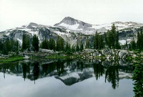
![Eagle Cap and Sunshine Lake...]() Eagle Cap and Sunshine Lake
Eagle Cap and Sunshine Lake
We were in the middle of a great three days in the Lakes Basin of Oregon’s Eagle Cap Wilderness. Sure it was Labor Day weekend and there were hundreds of people around, but you still can’t beat a wonderful Wallowa weekend. Our hike in the previous day was tasking because we were out of shape and decided there were just too many things we wanted with us. Spare shoes, a flora and a few cans of Pepsi my lovely wife stashed in my pack when I wasn’t looking. Our camp was above Mirror Lake in a lovely little glade encircled by house size rocks with a little spring. We were quite tired and slept little the first night due to fatigue and noise including yelling people and barking dogs. But thanks to the huge granite block structure of the area we could see no one from our camp even though we figured four or five other parties were fairly close by. I must admit the Pepsi really hit the spot.
![Eagle Cap above Mirror Lake...]() Eagle Cap and Mirror Lake
Eagle Cap and Mirror Lake
The second day of our trip we took a hike of a few miles around the Lake Basin loop passing by Sunshine, Crescent, Douglas, Craig, Moccasin and Mirror Lakes. Crescent Lake was especially beautiful with complete stillness reflecting the huge rugged granite ramparts to the north. Arriving back at camp weary from the hike and constant encounters with an endless stream of people we decided to take a nap. The air was cool enough, but I felt stifled in the tent. Plus I didn’t come to the Wallowas to lie in a tent during the day. The wife was more tired than I and was quite contempt to stay horizontal. So I told her to enjoy her nap, I was going out for a couple hours. There was a big mountain nearby with my name on it.
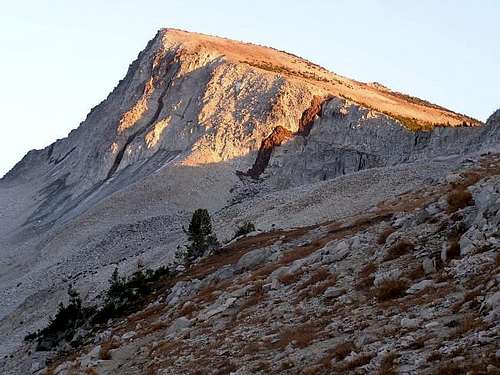
Eagle Cap is not the highest mountain in the Wallowas, but it’s one of the more impressive and is the center point of the range, with most major canyons radiating out from its general vicinity. It is a huge half dome shape with vertical faces on the north and east and a rugged connecting arête to Glacier Peak to the south. During periods of alpine glaciation large moving ice bodies flowed off these slopes, with the last active glacier ceasing life in the 1930s. Today this is represented by a large ice field on the slopes between Eagle Cap and Glacier Peak. The west side is formed by a huge rugged slope falling over 3,000 feet into the East Fork Eagle Creek canyon. The mountain is light granodiorite with highlights provided by dark basalt dikes slashing through the mass. As spectacular as the mountain is, it doesn’t take much to get to the summit.
![Eagle Cap in the sunset from...]() Eagle Cap at dusk. Photo by Brian Jenkins
Eagle Cap at dusk. Photo by Brian Jenkins
From Mirror Lake the trail climbs slightly to the west passing by Upper Lake. This is the highest lake in the area being at timberline. From here the trail takes the hiker up a steep slope over the headwall of the East Fork Lostine River source. On top the trial turns to the east along the ridge forming the northwest corner of the summit mass. In this area some very large bodies of perennial snow are passed. Then the trail switchbacks up loose rocky soils of the west slope to the brim of the summit. The slope breaks to the north and becomes very gentle. There are trees almost to the summit here, but they are bent and stunted by the ferocious winds that rip the area. The top is formed by a large flat area that is sadly severely impacted by heavy hiker use. The growing season here is very short and the thin fragile soils are pulverized by thousands of footfalls each summer. Another disappointment was all the people on the summit.
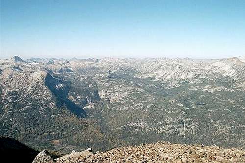
But soon the masses headed down. There was just me and one other guy up there who was shirtless in the cold brisk wind. He asked me to take his picture, and then he took mine and left, leaving me along with the summit. As with all the Wallowa summits the view from the top is tremendous, but due to placement it’s a bit different from most. Being the centerpiece of the range there is a featured view of numerous glacially carved U-shaped valleys radiating out. And of course there is the lake studded Lake Basin at the north foot of the peak. During glacial periods this was a huge neve field that supplied snow to the huge flowing valley glaciers. It was a view hard to leave, but it would be getting dark soon and I left my better half alone in camp.
Heading down was much more fun than coming up. Once I got low on the northwest flank it was time to jump off onto the north slope and glissade down through the endless September snow packs. In this area I found lots of a brilliant yellow draba, Draba lemmonii. The interesting thing about this compact alpine plant is its distribution being primarily in the Sierra Mountains far to the southwest. The Wallowa occurrence represents an unusually large disjunction. I got back to camp a little before dusk became dark and enjoyed a meal that really hit the spot. A thin layer of clouds moved in for the second night ruining our anticipated star show, but it was still a good night and I slept much better than I had in a long time despite the hard ground.
![This is the Lake Basin from...]() Lakes Basin from Petes Point
Lakes Basin from Petes Point
The next day we just enjoyed camp and the setting, but noted the air was cooling as we packed up camp. The weather held, but we could see the change slipping in as we headed down the East Fork Lostine canyon toward the trailhead. It was sad to leave the high subalpine forest and drop down the handing valley to the dense forest below, but the idea of getting home to a shower and real bed was inviting. At the trailhead we sat on rocks in the river and soaked our tired feet in the cold water, which really revitalized us for the three hour drive yet to come. After talking about it for years, we had finally spent some time in the Lake Basin.
Comments
No comments posted yet.