
|
|
Route |
|---|---|
|
|
36.16860°N / 115.4947°W |
|
|
Scrambling |
|
|
Spring, Fall |
|
|
Half a day |
|
|
Class 3 |
|
|
Moderate |
|
|
Overview
This is a half day loop scramble from the Willow Springs picnic area to the summit of White Rock Mountain and back. You gain about 2,250’ in elevation and there is some nice bouldering up the gully. If you pick your route carefully nothing exceeds 3rd class. This is an easily accessible mountain with a myriad of scrambling routes all around it. Most visitors are content to do the 10K hike around the base of the mountain and would be surprised by some of the nice climbing on the sandstone above them.Getting There
From Charleston Blvd and the 215 Beltway in the western part of Las Vegas, take Charleston Blvd. (Highway 159) west for about 5 miles until you reach the entrance to Red Rock Canyon NCA. Once inside the park, follow the 13 mile loop road for about 6 miles to the Willow Springs cut off. Follow this road almost to the end of the paved portion which will put your vehicle near the exit from Graffiti canyon. There is a restroom on your right and some interesting ancient art on the sandstone near the beginning of the trail. You should allow about 30 minutes driving time from the strip to the entrance station at Red Rock.Route Description
Start counterclockwise on the 10K trail that goes around White Rock Mountain and follow it up onto a small plateau that you pass on a northerly course. Look for the East Gully on your left and leave the trail before it drops down toward a wash to head toward the Gully. As you approach, look for cairns and once you find them the route is fairly well marked.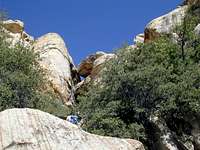 large hole
 Dead Ponderosa
 Upper canyon
After enjoying a snack and the views, look to your south toward North Peak
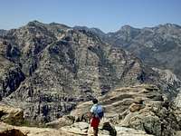 View south to N Peak