|
|
Route |
|---|---|
|
|
36.94730°N / 118.4054°W |
|
|
Scramble |
|
|
Most of a day |
|
|
Class 2 |
|
|
Approach
Distance: 4 miles
Vertical: 3700 ft
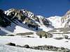
The lower part of Armstrong Canyon consists of two large gullies separated by a significant ridge. The road ends in the left-hand (eastern) gully, and it is this one that is usually ascended. A climber’s trail along the right-hand side of this gully expedites the climb once the snow is gone. Eventually, the left gully peters out and one should traverse over to the right-hand drainage by the 10,000 ft level. Climb this drainage directly beneath the steep NW wall of Armstrong Canyon up onto a moraine bench at 10,300 ft. At this point turn north and climb the 30-35 degree talus slope up to the top of the ridge. Angling to the right will decrease the grade a little and cross the ridge at a lower point, requiring less of a downclimb on the other side.
Once across the ridge, cross the bowl and begin an ascending traverse toward the ridge to the northwest. Once across this ridge, traverse the north side of the peak to the pass on the Sierra Crest at 12,200 ft. From here it is a very easy stroll across a plateau to the east ridge of Mt. Pinchot.
 |  |  |  |  |
Route Description
Distance: 0.6 miles
Vertical: 1200 ft
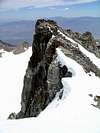
Mt. Pinchot’s east ridge is a very enjoyable scramble that is only as difficult and exposed as you want it to be. Staying directly on top of the spine of the ridge will provide the most adventure, running from class 2 up to exposed, challenging class 3. The nice thing about the route, however, is that it is not at all committing. At any point the spine gets too spicy for your taste, you have the reassurance of knowing you can easily back off onto class 2 talus slopes below the spine.
The lower half of the ridge is topped with a fairly narrow spine of shattered blocks. Easy class 2 talus covers the south slope of this section, while the north slope gets increasingly more exposed the further up the ridge one climbs, culminating in about 400 feet of near vertical at a significant bump on the ridge about half way up.
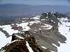
A little beyond the mid-way bump, the exposure is greatly reduced as the ridge merges into the main body of the mountain. From here the talus is on the north side of the ridge, and the exposure is on the south side. The grade gradually slackens as one approaches the gently rounded summit. As of May 2005, there was a nice Sierra Club aluminum cylinder to house a register on the summit, but there was no register within it.
 |  |  |  |
Essential Gear
In snow-covered conditions, normal snow gear such as crampons and ice axe can be useful on the steep slopes of the approach. Once the snow is gone, no special equipment is needed.
Miscellaneous Info
If you have information about this route that doesn't pertain to any of the other sections, please add it here.