Getting an Early Start
After spending quite some time perusing Bob Burd’s and a few others’ climbing and backpacking trip reports, coupled with a few of my own backpacking exploits into the Sierra backcountry, I had maintained thoughts about taking on that type of challenge. It wasn’t until recently that I decided I was tired of reading and not partaking in the adventures. Too short on time, money and technical experience to undertake any extended Sierra climbing I conceded to look closer to home and set a goal to climb the San Diego County Sierra Club’s Top 100 Peaks in San Diego County. Since the 2009 New Year I’ve been on a peak bagging kick, having climbed 8 peaks since, but having a baby born in December has made the opportunities to get out and climb consistently extremely hard to come by. So for the time being, I’ve settled for what time would allow and a traditional jaunt to the hills every weekend was born. The following report is a few notes about my adventures (or misadventures) up the steep walls of El Capitan to summit El Cajon peak on Sunday, January 26, 2009.
The annoying beep of my phone alarm pulsated in my head, disrupting my dreams of who-knows-what, and caused me to stir enough to one-eye the time, 5:40 am!! I clambered out of bed; washed my face, brushed my teeth, slapped on some deodorant and slipped into my comfortable, yet ill-suited climbing apparel. The weather had been pretty crappy, wet and cold lately, so I made sure to throw on a long sleeve T-shirt and my fleece vest for some added warmth. As was customary before my traditional weekend climb, I woke my girlfriend to tell her I was heading out. She kindly asked if I could first change the baby’s diaper and I complied. After getting some one on one, poopy-time with baby Brooke, I laid her back in bed, gave them each a kiss, grabbed some snacks and extra water and headed for the door.
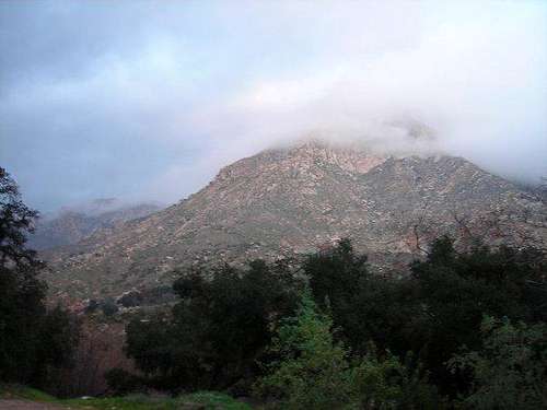
It was nearing 6:30 as I sped down Highway 67 from Poway to the trailhead off of El Monte Road in Lakeside. The wiper blades noisily erased the morning drizzle and the rhythmic flow of Tupac’s “California Love” drummed loudly along with my excited thoughts about the morning’s approaching climb. I had read a few reports about El Cajon Mountain and decided to forgo the arduous 11 mile hike that routed climbers from the west side of the mountain, up the north shoulder and on up to the peak, in favor of a shorter, more scrambling route from the south. I was looking to climb and the Class 2/3 route up the South Arête of El Capitan to the El Cajon summit was more of what I had in mind. After driving several, curvy miles on El Monte Road, I rounded a corner and smack, there she was. El Capitan, not the colossal granite mass of her namesake in Yosemite Valley, but amazing still and even better looking and larger than I had ever imagined.
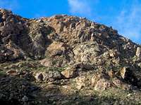
Southeast Face of El Capitan
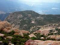
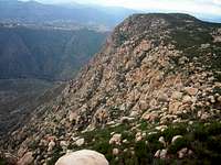
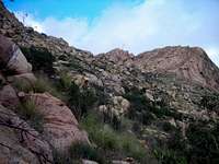
By 7 am I had found parking at the correct trailhead near the sign stating “No Camping/No Fires”, had all my gear loaded and was starting down the path that leads across the small riverbed directly south of the base of the mountain. As the trail meandered over a small incline of shrubbery the bulging south face of El Capitan towered above, beckoning for those willing to come and explore. As I came across the old Jeep trail mentioned in the previously stated reports I couldn’t remember what direction to follow for the South Arête trail. Should I keep going straight towards the mountain or take a left and follow the trail to the west? From my perspective, there were two main arêtes coming off the peak, one falling to the southwest and the other to the southeast. I couldn’t see much of a difference between the two climbs so I gambled and chose to keep going straight (which is the wrong route if one is headed for the South Arête trail) and headed for the arête coming off the southeast corner of El Capitan. It was at this point that the true adventure began.
![El Cajon Mtn - El Capitan 2]()
![El Cajon Mtn - El Capitan 3]()
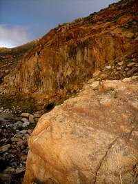
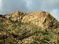
I skirted the right side of the rock quarry wall and slowly gained ground on the looming rock face by employing a use trail I came across. As the trail switch backed up the rocky slope, the boulders became larger and the route more steep. A quick glance back showed a dense fog layer disguising the view to the south and the east. El Capitan Reservoir and its dam were barely discernible to the east and the route I had come from was no longer visible. Slowly, the dirt trail became a complete boulder hop and I knew I was in for a treat. I followed a fountain grass-filled rocky lodge north along the east face until I came across a well-anchored, knotted green climbing rope that extended up the cliff. After a few reassuring tugs, I gripped the knots and hoisted myself up to the next shelf. From there I scanned the rocks above for any route with plenty of holds. After several failed attempts up a couple of boulder filled gullies, I decided I needed to find a safer route. Again I struck out north along a ledge on the east face, slowly gaining elevation as I climbed.
![El Cajon Mtn - El Capitan 4]()
![El Cajon Mtn - El Capitan 5]()
![El Cajon Mtn - El Capitan 6]()
![El Cajon Mtn - El Capitan 7]()
![El Cajon Mtn - El Capitan 8]()
![El Cajon Mtn - El Capitan 9]()
![El Cajon Mtn - El Capitan 10]()
![El Cajon Mtn - El Capitan 11]()
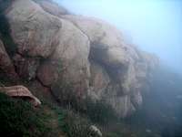
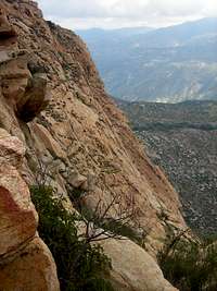
The sheer, granite walls on either side of me provided no comfort as I struggled to look for a route. Each gully I came across slowly choked out to a point that either I could no longer climb or was too chicken-shit to chance the route with the exposure I saw. I was nearly on the verge of quitting, not because I wanted to, but because I was afraid if I continued I might inflict bodily harm or maybe even something worse. At one point, a small boulder pile I was using to hoist myself up quickly collapsed and the rocks tumbled down for what seemed like days to the grounds below. Luckily, I regained my composure enough to retrace my steps, explored a few other options and somehow came across a climbable, yet steep rocky gully that looked to head up the mountain.
![El Cajon Mtn - El Capitan 12]()
![El Cajon Mtn - El Capitan 13]()
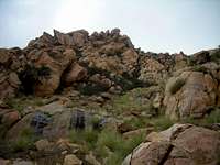
Pretty much clambering up on all fours, I slowly made my way over and around the boulders on my way up the rocky gully. Eventually the course turned into about an eight-foot wide outcropping running northwest on the east face, which contained plenty of handholds, little exposure and a few little caves to look at. As the steepness slowly dwindled and shoots of grass took over where rock had once been, I knew I was nearing the top. The foggy layer covering the mountain made it extremely hard to see and before I knew it I was walking along flat ground and stumbled upon a mass of boulders marking the summit of El Capitan.
Summiting El Cajon Mtn
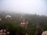
I sat down to take a breather, opened up my 8.5 X 11 topo of El Cajon Mountain and tried to decipher how I should best make my push at the summit. As I stared back and forth from the map and my surroundings, I knew I was in store for a wild one. The fog made it impossible to see any land features and my cropped and printed map had no scale to determine how far I needed to travel. Basically I was left to wander from the top of El Capitan in what looked like a north/ northeasterly direction until I came upon some type of hill resembling the peak. This turned out to be a disaster, as I wandered around for nearly an hour climbing towards each and every knob I could see through the dense fog. I had almost given up hope when I stumbled across a small cairn and what looked to be a trail. I followed the line of ducks a short ways before I stumbled upon the USGS marker next to a bigger boulder with a smaller rock situated on top. I glanced around but didn’t see register anywhere. After a few photos and a taking brief phone call from a buddy in Kansas City, I caught glimpse of what looked to be the register located in an old cookie tin tucked under and between two larger rocks.
![El Cajon Mtn - El Capitan 18]()
![El Cajon Mtn - El Capitan 17]()
![El Cajon Mtn - El Capitan 20]()
![El Cajon Mtn - El Capitan 19]()
Trekking Back to the Finish
I quickly signed the register, ate a small snack, and was on my way. Or so I thought. The only thing I can figure is that with all the fog and blind wandering I put myself through, I had lost my sense of direction. I walked for what seemed like an eternity before I even gave thought that I might have taken the wrong route back. The layer of fog that had engulfed the mountain all morning was starting to thin. It was still cloudy but I was able to see a short distance and I noticed off in the distance a small body of water to my right. Immediately, I questioned my mountaineering and navigational skills because I was pretty sure for my return trip, the El Capitan Reservoir should’ve been on my left.
![El Cajon Mtn - El Capitan 21]()
![El Cajon Mtn - El Capitan 22]()
I figured it was around 11 am so I searched the sky for the sun. I was hoping to catch a glimpse of it somewhere in the southeastern sky, but as my luck would have it the cloudy sky prevailed and not a ray of light poked through. It was at this juncture I decided I was wrong, my navigation skills sucked, and I was an idiot for thinking I had some sort of natural sense of direction. After cursing at myself for being such a schmuck, I whipped out my map and did my best to guesstimate my location. Since I could see the reservoir I figured I was at least on the correct side of the mountain I just needed to be on the opposite end. After briefly studying the topo I decided my best shot was to make my way across the top of the ridge and descend a narrow gully between the steep east face of El Capitan to the southwest and the El Cajon main climbing wall to the east.
![El Cajon Mtn - El Capitan 23]()
Pissed off, hungry as hell, and beyond embarrassment I set off to catch up on lost time. I wish my body had responded as my mind had but exhaustion was slowly setting in. My knees were starting to ache, my hamstrings were tightening and my quads were slowly beginning to cramp. All the climbing had taken its toll and I hadn’t even begun to climb down the steep, rocky slopes of El Capitan yet. I hacked and scrambled my way through a shrub and boulder filled route to reach a small waterway that descended the gully I had chosen. Battered and beaten I started my descent.
To my left was the main El Cajon climbing wall. I could see several climbers making their way up and down and wished I could’ve asked if they could see or knew of a nearby trail. I didn’t feel much like yelling though, and they probably wouldn’t have understood me anyways, so I just kept my mouth closed. The going was rough; I’m not going to lie. It felt like I spent the entire descent either on my ass or pretty close to it. Some of the rocks were slippery, some loose, but the majority just in my way. About three quarters of the way down I ran into a local who was out maintaining a trail they were using to haul up equipment. We chatted for a few minutes, discussed the mountain, and he pointed me down the trail he had just came up on.
![El Cajon Mtn Wall - El Capitan 24]()
![El Cajon Mtn - El Capitan 25]()
![El Cajon Mtn - El Capitan 26]()
![El Cajon Mtn - El Capitan 27]()
![El Cajon Mtn - El Capitan 28]()
![El Cajon Mtn - El Capitan 29]()
Rejuvenated from my first great bit of advice for the day, I lumbered on down the mountain. The use trail looped south around the east side of the mountain, crossed a few small gullies and finally connected back with the original trail just south of the rock quarry. I retraced my steps back to the car and finally dropped my pack with exhaustion. After eating a quick snack and gulping down some water I headed home. As I drove away I glanced back at El Cap a few times in the rear view. Though not as well known or nearly as large as her sister in Yosemite, she’ll always have a special place in my heart and I’ll never forget my little misadventure up her arêtes trying to accomplish my goal of climbing El Cajon Mountain.
Topo & External Links
All Photos of My El Cajon Mtn Climb
Comments
No comments posted yet.