A Bit of A Climb...
I had been intending to do Elk Knob for some time and I was excited to finally have a day to go. It was the day after a strong cold front blew through so the air was clear and cold. Temps at the trailhead were in the upper 20's and stayed right around freezing for the length of the climb.
![Elk Knob State Natural Area]() Elk Knob Entrance
Elk Knob Entrance
I started from the
Parking area off Meat Camp Rd. I had expected the trailhead to be harder to find but the North Carolina DNR has recently fixed the area up nicely. There is a
small sign on the west side of the road directing you into the park which is now known as "Elk Knob State Natural Area." As you enter the park you pass what looks like the makings of a nice
picnic area and soon arrive at the nice big parking area at the gate and
trailhead.
To the right of the gate is the
new trail the NC DNR is buildiing that will eventually take the place of the logging road that is the current route to the summit. It looks nice but its far from finished. I chatted briefly with a ranger who was there doing a little work on it and he stated that they had about 2200' of trail completed. The current trail is about a mile long and the new one will be slightly longer, so they have a ways to go. Nonetheless, the new trail looks like it will be nice, covered in packed gravel and following the softer contours of the mountain.
![Nearing the Summit]() The Trail
The Trail
That route is for the future though. I headed back to the gate and started the climb up the old dirt road. The trail starts climbing immediately and doesn't really ease up until you get to the top. The trail passes through a nice hardwood forest with no views for most of the way up although some
glimpses could be caught through the bare trees. The trail is fairly washed out in places but the park service has placed plastic barriers in spots along the trail to try and halt the progress of the erosion. About halfway up the trail splits, but the DNR has nicely put a
little arrow on a post pointing you in the right direction. As I climbed higher I was treated to
more views behind me as the trail makes a
beeline straight up the ridge to the summit. The trees become increasingly
stunted as you climb and are no more than 7 or 8 feet tall by the time you reach the top.
I managed to reach
the top in about 40 minutes. It was one hell of a climb. The trail gains something like 900-1000' over its mile length. The views at the top are more than worth it though. The road dead ends at a
stunning cliff-edge viewpoint on the north side of the summit. Closeby were the other peaks of the
Amphibolite Mountains while 20 miles away were the clearly visible peaks of
Mt. Rogers,
Whitetop, and the rest of Virginia's Iron Range. It was amazingly clear. The wind was biting though so after the standard
been-there-done-that pics I decided to
head down. Just below the summit I was taking in the
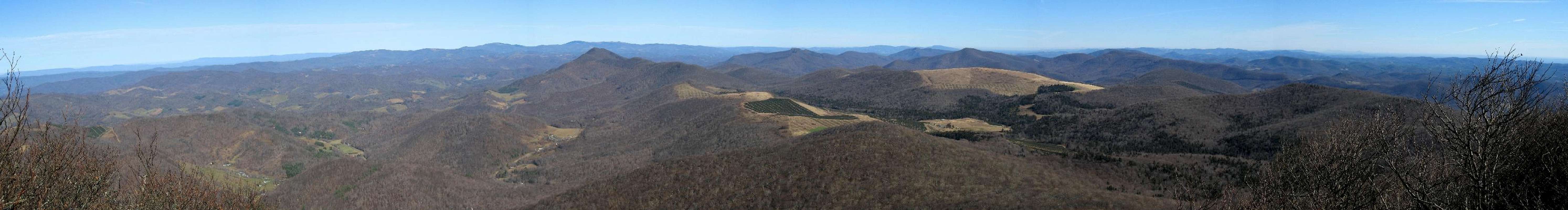
sweeping panorama to the south when I noticed a little side trail which promised clearer views. This path is on the left as you're descending. The little viewpoint treats you to great
panoramic views to the south. From the Boone area in the east the view encompassed
Grandfather Mountain, Sugar Mt (couldn't miss SugarTop, groan), Beech Mt, the
Roan Highlands, and even the
Black Mountains some
60+ miles away!
![Trailside Panorama]() Near the Summit Looking South
Near the Summit Looking South
The rest of the trip back was easy and uneventful. I made much better time coming back covering the mile or so from the summit in about 20 minutes. All in all it was a great hike. The trail is quite strenuous and my knees thanked me for taking my poles despite the short distance. It looks like the improvements to the area are well under way and its good to see that such a wonderful mountain will not suffer the fate of so many other peaks in the High Country. If you are considering coming to the High Country for a visit I would definatley put this mountain on your itenerary.
The View North From Elk Knob |
The Nuts & Bolts
Trailhead: Elk Knob State Natural Area off Meat Camp Rd. at
Pottertown Gap.
Trailhead Coordinates: 36.3324°N, 81.6909°W
Trailhead Elevation: ~4600'
Summit Elevation: 5530'
Total Elevation Gain/Loss: ~930'
Trail Length: About 2 miles round-trip, give about 45 minutes to climb and 30 to descend. Also, possibly as soon as 2007 (but that's unlikely), there will be a new trail to the summit which will be longer but less strenuous than the current route.


Comments
Post a Comment