
-
 6740 Hits
-
 74.92% Score
-
 5 Votes
|
|
Route |
|---|---|
|
|
47.31561°N / 10.45006°E |
|
|
Hiking |
|
|
Summer, Fall |
|
|
A long day |
|
|
High trail with rock scramble and some secured passages |
|
|
Overview
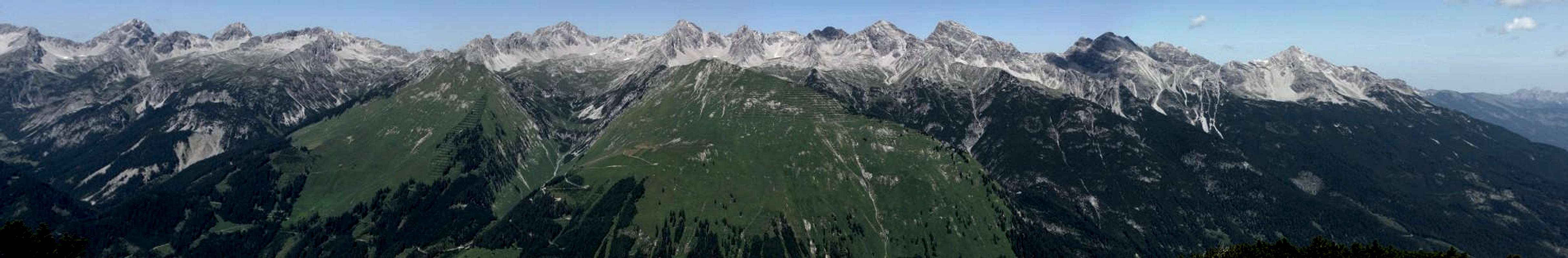
 Noppenkar and Luxnacher Sattel
To experience the remoteness and grandeur of the Hornbach chain you should hike the Enzensperger Weg, one of the most beautiful high trails of Allgäu mountains.
This trail connects Herrman-von-Barth Hütte with Kaufbeurer Haus and Hinterhornbach, traverses several huge cirques on the south side of Hornbach chain and climbs steep notches. It offers great views on the Hornbach chain main summits and over the Lechtal valley and the Lechtal mountains.
If you are a experienced and strong hiker, some summits can be “picked” while hiking this trail: Plattenspitze, Balschtespitze (UIAA grade I), Südlicher Söllerkopf (easy off-trail scramble), Rotwand (short UIAA grade I climb) and – as a highpoint – Bretterspitze.
But don´t underestimate this trail: it is a long days hike and every additional summit besides Bretterspitze is a huge effort.
From Herrman-von-Barth Hütte you need 5,5 to 6 hours to Kaufbeurer Haus; add 1,5 – 2 hours for the descent to Hinterhornbach, ¾ hours for Bretterspitze and there you are!
Balschtespitze or Plattenspitze: additional 2 hours;
Rotwand: additional ½ hour
Südlicher Söllerkopf: additional ¾ hours.
The best thing is to do this hike from Barth Hütte to Hinterhornbach. Unfortunately Kaufbeurer Haus is a private hut, guarded only in summer on weekends with good weather, otherwise accessible only with special keys and without meal service. An overnight stay at Kaufbeurer Haus is not as comfortable as one at Herrmann-von-Barth Hütte …
You will be astonished how lonely this part of Allgäu mountains is – you will hardly meet other hikers during that day.
  |
Getting There
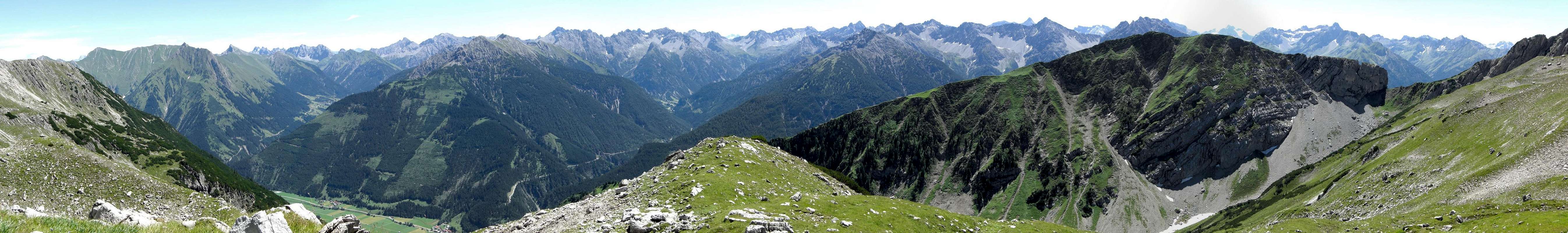
 Noppenkar
The main trailheads for Bretterspitze are Hinterhornbach in the Hornbach valley and Häselgehr in the Lechtal valley.
You reach Lechtal valley
Follow Lechtal valley road number 198 from Reutte or from Lech / Warth until you reach Häselgehr. The trailhead is at the Häselgehr church on the orographic left side of Lech river.
The village of Hinterhornbach can be reached directly from Lechtal valley road by leaving the road at Martinau or Stanzach in the direction to Vorderhornbach. At Vorderhornbach follow the signposts to Hinterhornbach. The trailhead is at the western end of the little village: go on the road by passing the church and use the first road which branches off to the left and immediately crosses Hornbach creek on a bridge. Behind the bridge is the parking area (2009: free parking).
Trail Description
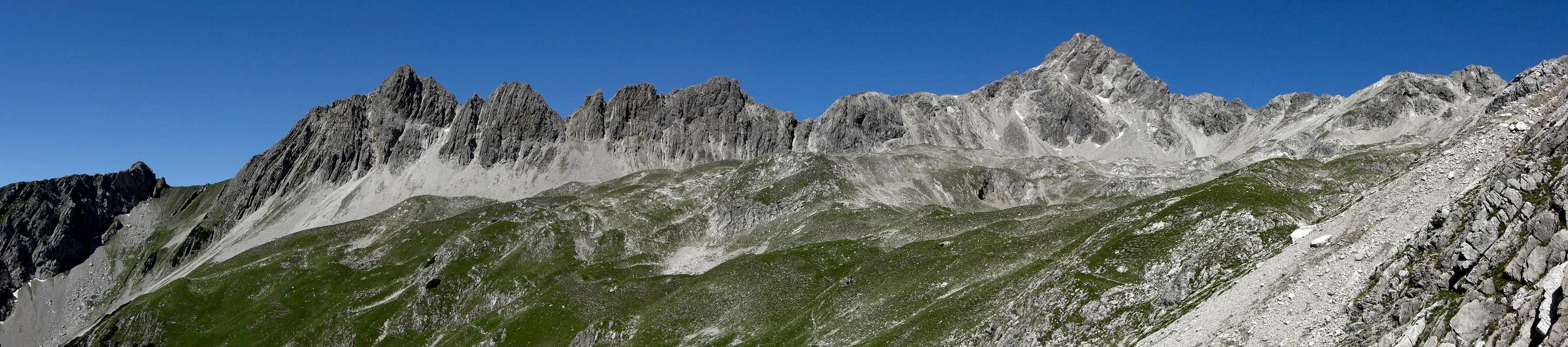
 Herrmann-von-Barth hut with Ilfenspitze
Getting Started
Herrmann-von-Barth Hütte
From Elbigenalp follow the mountain road to Kasermandl Inn and to the resupply cableway of Herrman-von-Barth Hütte. At the end of this road follow trail 436 to Herrmann-von-Barth Hütte.
 Alpenglow on Ruitelspitzen as seen from Barth hut
From Hinterhornbach parking area follow trail number 432 into Hornbach valley. Before you cross the Hornbach creek go straight on on a narrow trail which soon zigzags steeply up the north slopes of Hornbach chain and traverses high above Hornbach valley the Faule Wand location. Again there are some steep zigzags up over steep meadows. The trail reaches the huge Schönecker Kar and climbs up this cirque to a notch called Schönecker Scharte. On the south side of the notch the trail descends steeply to the Enzensperger Weg. Follow the Enzensperger Weg in western directions to Herrmann-von-Barth Hütte.
With this variation you hav a great 2 day hike with start and end at Hinterhornbach and an overnight stay at Herrmann-von-Barth Hütte (reservation required). On the first day you additionally can summit Plattenspitze and / or Balschtespitze which are not far away from the Barth Hütte.
Kaufbeurer Haus
From Hinterhornbach parking area follow trail number 434 in many switchbacks to Karköpfl and Kaufbeurer Haus.
 Kaufbeurer Haus, Urbeleskar and Hochvogel summit
Enzensperger Weg Trail Description
The description is from Barth Hütte to Kaufbeurer Haus.
From Herrmann-von-Barth Hütte follow the trail number 432 into Balschtekar. The trail traverses the impressive east rock walls of Wolfebner Spitze and reaches soon the trail junction with the trail from Schönecker Scharte.
 |
At the trail junction possibility for the side trip to Balschtespitze (additional 2 hours, UIAA grade I, off-trail).
 Balschtekar
The trail traverses the huge Balschte Kar (spring near trail junction) and climbs steeply up to Balschte Sattel between the rugged Söllerköpfe and tiny Rotwand peak.
 Balschtesattel and Rotwand
From Balschtesattel side trips to Südlicher Söllerkopf (additional ¾ hour, easy off-trail) and / or Rotwand (additional ½ hour, UIAA grade 1, fixed steel ropes).
East of Balschtesattel is the huge Noppenkar. The trail descends some 100 meters and starts to traverse this beautiful and huge cirque.
 |
West of the cirque is Kreuzkarspitze, east of it impressive Noppenspitze and the south arête, which is the eastern limitation of Noppenkar. A notch in this south ridge, called Luxnacher Sattel is the next aim.
 Noppenspitze as seen from Noppenkar
The sharp and bold Hintere Wand is standing impressive above Luxnacher Sattel and south of it. The trail reaches the col after a short ascent and immediately turns north and descends again into the next cirque, called Sattelkar. Noppenspitze and Sattelkarspitze with their south ridges are limitating this cirque. There is a short part of the trail secured with fixed steel ropes until you reach the bottom of the cirque and the traverse to the south ridge of Sattelkarspitze.
 Near Luxnacher Sattel
At Luxnacher Sattel and in the Sattelkar there are trail junctions with trails coming up (or leading down) from (to) Häselgehr.
East of Sattelkarspitze south ridge you arrive at another cirque, called Woleckleskar. Again this cirque is traversed to the south ridge of Woleckleskarspitze, a winter ski hike aim. Where the trail traverses the south ridge there is a beautiful meadow for a midday break with terrific views into Lechtal mountains.
 |
After this well deserved break you traverse into Gliegerkar with Gliegerkarspitze and Bretterspitze, standing high above this cirque. At ist east end the trail starts to ascend steeply to the trail junction with the southern summit trail to Bretterspitze. The trail ascends steeply up to Griesschartl, a bold notch between Bretterspitze an a wild tower south of the summit.
Below Griesschartl the rock part of Enzensperger Weg starts with some interesting and easy rock scramble, secured with fixed steel ropes. Pay attention: in july 2009 those ropes where in a not very good condition. But the rocks are not too difficult so you have not to use the unsecure parts of the ropes.
After Griesschartl the trail traverses the impressive and steep east rock faces of Bretterspitze on some exposed ledges – always partly secured with steel ropes. Impressive views of Urbeleskarspitze and deep views of Seekar ar the reward for the effort.
 Rock section at Griesschartl Rock section at Griesschartl |  Rock section at Griesschartl Rock section at Griesschartl |  Urbeleskarspitze as seen from Griesschartl Urbeleskarspitze as seen from Griesschartl |
The trail reaches its highest point at Schwärze Scharte, a high col between Bretterspitze and Urbeleskarspitze.
A must is the summit of Bretterspitze as a short side trip by using the marked trail of the Bretterspitze east ridge. The trail leads over ledges and short rock steps and soon reaches the summit with its breathtaking views: Allgäu and Lechtal mountains, Ötztal glaciers and Tödi / Glarner Alpen in the far west are visible on clear days.
 Summit view from Bretterspitze
Back to Schwärze Scharte, Enzensperger Weg zigzags steeply down to Urbeleskar. You can partly glide down on snow fields and / or scree to shorten the descend. Kesselboden and Kaufbeurer Haus as the end point of this great trail is soon reached.
Accomodations
 Bretterspitze summit
In Lechtal valley there are all sorts of accomodations: Hotels, Inns, private Bed & Breakfast and Camping areas.
For general infomations please refer to: Lechtal tourist page
More detailed informations about accommodations in the nearest villages can be found on the homepages of
Nearby mountain huts (alpine club or private huts) are:
Gear & Trail Conditions
 Noppenkar inhabitants
Enzensperger Weg is a summer and autumn hike. It is mainly a south exposed route but pay attention to the highest parts of the trail being exposed east and north, so snow may hinder the traverse in early summer.
You need normal hiking gear with good shoes. In early summer crampons and an ice axe might come in handy.
As the more difficult passages of the southern ascent are secured with steel ropes you need no rope or special gear for belaying. You should be used to exposed rock scramble.
Check the current weather here.
Recommended topo map:
Alpenvereinskarte, scale 1 : 25.000
Blatt 2/2, Allgäuer - Lechtaler Alpen, östliches Blatt, 2006