
-
 3124 Hits
-
 72.08% Score
-
 2 Votes
|
|
Custom Object |
|---|---|
|
|
37.30330°N / 119.524°W |
|
|
Custom Object |
1
PAROFES=================================
From the town of Bishop California drive seven miles west on Highway 168, also known as Line Street, to its intersection with Buttermilk Road. Take this dirt road for 3.5 miles to where you begin to see many large boulders to your right. There is a large dirt clearing here. This is the Frontside Parking.
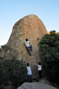
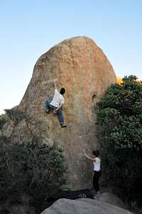
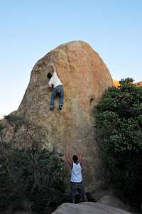
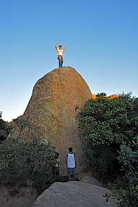
Park in the Frontside Parking area. Looking up toward the crags, you can easily pick out Wrangler Rock on the left, The Owl in the middle and Skin Diver on the right. Dune is shaped like a cone and is located in front of Wrangler Rock. It's also the closest formation to the parking area.
==========================================
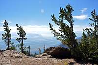
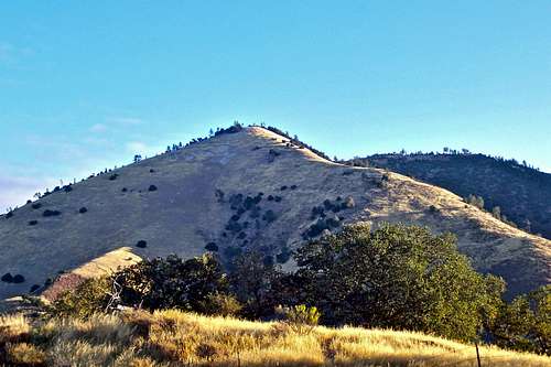
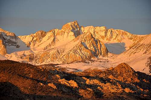 Mount Humphreys, another beautiful mountain view from The Buttermilks
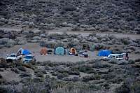 camping in bad style
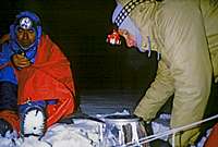
There are many campgrounds nearby that can be used. Do your best to use the campgrounds, at least for extended stays. In addition to the nearby campgrounds, there are many unofficial campsites, some near running creeks, that can be used. In any event, camping in the parking areas is the worst to choose.
The following links should help finding a good campsite
Horton Creek Campground
Rock Creek Canyon
Inyo National Forest
Bishop Creek and vicinity camping
Rock Rose
================================================================
Profile Image background:
==================================================================
Getting There
| Highest Point | Elevation and major routes |
|---|---|
| Cathedral Peak | 6000 Feet, Rocky Ridge, Mission Canyon Trail, Waterfall Trail |
View Sea World San Diego in a larger map>LINK TEXT HERE
Route Description
============================================
| Name of Mountain | Name of Mountain |
|---|---|
| major streams | Trails |
Essential Gear
 | ||
 |
 |
 |
========================
 approaching storm on Liberty Ridge approaching storm on Liberty Ridge |
=========================
 | Over 14000 Feet |
|---|---|
| over 13000 Feet |
External Links
 |
 |
 |
 |
 |
 |
 |
 |
 |
 |
 |
 |
 |  |  |
| | |  |
| |
| |
West Ridge of Grass Mountain
Looking at Grass Mountain in Los Padres National Forest from a distance, the west Ridge looks quite tame. But when you actually hike the trail, your endurance and resolve are thoroughly tested. There are no rocky sections, nor are there any switch backs. In short, West Ridge Grass Mountain is no walk in the park. After the initial three quarters of a mile, the steepness of the trail becomes unrelenting. You gain over 2000 feet in only 1.2 miles. Since most of this mountain is covered by chaparral, your choice of routes are limited. The West Ridge, oddly enough stays free of chaparral and is the most reasonable route to the summit. Be prepared for a difficult hike with great views. During the summer months the creeks are bone dry and the area is quite hot. Carry three quarts of water. The return can be confusing. So, carry a compass or a GPS and make notes on the way up.How to get to the trailhead and Red Tape:

Grass Mountain trail is located within the Midland School property. You need to get a permit to enter the area.
Drive into the school and find the box marked "Hiking permits." You need to fill out a permit form, leave a copy in the box and carry one with yourself. Get back onto Figueroa Mountain Road again and drive another two miles up the road. The road makes a sharp turn to the right and crosses a cattle guard. Shortly after the cattle guard there is a gate. You can park here, but not too close to the gate. The trailhead is right across from the gate. There is also a large pullout just before the sharp turn on the road and the cattle guard.
The Hike:
1- Start your hike at this unnamed trailhead at an elevation of 1329 feet. GPS reading, 34.74171 -120.062089
2- Heading northwest and keeping the creek to your left will bring you to the first gate. Climb over the gate and continue on the trail keeping the creek to your left.
3- After hiking through a meadow climb over a second gate. 34.7444 -120.0588
4- You will come to a three-way fork on the trail. Take the left one. 34.7459 -120.0568
5- Cross the creek over medium size boulders. 34.7465 -120.0560
6- Another fork on the trail is reached. Take the right one. 34.7472 -120.0555
7- Cross another creek and bear left. Hike up a meadow to the base of the lower ridge. 34.7551 -120.0525
8- Follow the trail that continues on the south side of the west ridge. After a short gravel covered hillside reach a dead tree near the broad summit of Grass Mountain. A clump of trees will provide a welcome shade.
34.76248 -120.041857
Summit elevation, 3685 feet. Total elevation gain 2356 feet. Total one way distance 2.25 miles.
West Face of Cathdral
| A |  | 10d |
| B |  | 10a |
| c |  | 10b |
| A | | 10d |
Text & Pic
 |
|
 |
|
weather


Hidden Valley Campground

 |
 |
 |
 |
|---|
Chimney Rock
The Blob
Intersection Rock
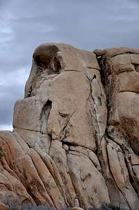
Old Woman
The Wall
Google Map
View Larger Map
================================
View Larger Map
Little Egypt
Frontier, right sideFrontier, left side
Lambada Dome
Mussypotemia
 |
 |
 |
 |
|---|

Upper Right Ski Track, West Chimney & Banana Cracks
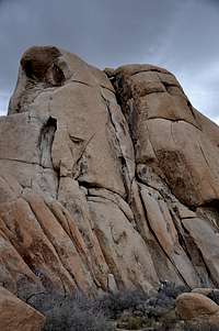
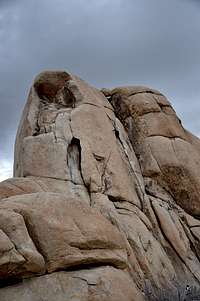
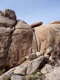
Intersection Rock located in Joshua Tree National Park's is a gift that keeps on giving. The majority of the routes are located on the west and southwest side of this rock. The north face, however, has its own share of routes. The north face, therefore always in the shade, is the steepest side of Intersection Rock. The most prominent features of the north face are two crack systems, The Right Ski Track and Left Ski Track. Both of these routes are fairly difficult, except for the upper part of Right Ski Track. As luck would have it, you do not have to climb the lower part of this crack, rated 10b/c, to get to the upper part of it. This may be the reason for many climbers seeking an easier route to the top of Intersection Rock to choose Upper Ski Track route, rated only 5.3.The approach to to Upper Right Ski Track is very simple and involves scrambling on low angle rocks on the northwest shoulder to reach a ledge/ramp nearly half way up the rock. There is, however, a much more interesting way to make the approach. Climb a low angle hand crack called "Beginner's Three," rated 5.3, to the same ledge. Follow this ledge to its end which is the base of of our route. Upper Right Ski Track is a very wide crack that takes you all the way to the top of Intersection Rock.
==============================================
The hulk of a rock known as Intersection Rock is without a doubt the most famous formation in all of Joshua Tree National Park's. There are numerous routes with varying degrees of difficulty all around this rock. The most prominent feature of the west face is a gaping crack known as west Chimney. This feature runs from the very base all the way to the top of the formation. Considering it's low technical difficulty level, it should come as no surprise that it became one of the first routes to be climbed on this rock and in fact in all of Joshua Tree National Park.
Located just to the right of The Flake, west Chimney is about 150 feet long and with a rope long enough it can be climbed in one pitch. Having witnessed a number of difficulties experienced by different parties I am convinced that it is best for this route to be done in two pitches. This way you are always closer to your partner wich makes communication simpler and reduces rope drag. West Chimney is not a pure chimney climb. You will find many features inside the chimney to use as handholds and footholds.
Descent: If you are climbing with two skinny ropes, you can get to the bottom with just one rappel from any one of a number of rap stations on top. If you have just one rope, rap down to Bat Ledge, on the west face, then make another rap to the bottom from there.
Essential Equipment: Standard rack with extra large pieces of protection, slings, and one or two rope===============================================================
Banana Cracks Rock is a small formation in Joshua Tree National Park's, California.
Entering Joshua Tree National Park from the western entrance and driving down Park Boulevard you will see many singular formations on both sides of the road. Some of these formations are literally next to the road such as Roadside Attractions Rock and some others such as Dihedral Rock and Banana Cracks Rock a bit further. Although this rock is over-shadowed by its much larger neighbor, Hemingway Buttress, it still gets its share of popularity. The main reason for this popularity is the steep cracks on its west face.
Banana Cracks Rock is short, only about thirty five feet, but it sits on top of a jumble of large boulders about another thirty five feet high themselves. The approach to the base is somewhat precarious to say the least. Some climbers rope up for the low fifth class direct approach to the base. The safest approach, however, seems to be scrambling on large boulders on the left side of the west face. In either case, if a climber thinks he/she is ready for the difficult climbing on Banana Cracks, then they are willing to make the awkward approach to the base.
Although there is a difficult bolted route on the overhanging arete of this rock, most people come for the crack lines, most likely for the Right Banana Crack, rated 11a. The Left Banana Crack, rated 10b, makes for a good warm up route for the real objective, the Right Banana Crack. To descend you can either rappel from the top or scramble down the left side.
=============================
Select Routes of Banana Cracks Rock, west face |
|
| A | Papaya Crack, 11a, standard rack |
| B | Left Banana Crack, 10b/c, standard rack |
| C | Right Banana Crack, 11a, standard rack |
| D | Tails of Poodles, 10b, standard rack |
==========================
From the west enterance to Joshua Tree National Park, drive about eight miles to a large paved parking area with a bathroom. This parking is about two miles past Quail Springs parking, and it has its own sign, “Hemingway” indicating that you have arrived. Looking toward the west you will see the elongated Hemingway Buttress at a few minutes walking distance.
There are at least two trails heading out toward different nearby formations and an Access Fund trail leading toward the main Hemingway Buttress. Head toward Hemingway Buttress for about a hundred feet then go right toward a clump of rocks on the right. Go around the rock to see the west face. Banana Cracks are unmistakable.
3 in a row, left
|
|
|
|
|---|
Just playing
 | Over 14000 Feet |
|---|---|
| Potrero John is nearly vertical, about eighty feet tall at its highest point, and sports seven side-by-side bolted routes. There are no obvious distinguishing features on any of the routes except for their difficuty ratings. Be forwarned that it’s very easy to confuse one route with another. Although the difficulty ratings don’t exceed 5.10d, you need to be prepared to lead at least in the mid 5.10s to climb the routes of the left side, and probably in the low 5.11s to do the climbs of the right side. Some of the climbs on Potrero John have their own two cold shut anchors. There is also a third class down climb on the right side of the formation. There are a number of hairline cracks on the face. It’s a good idea to take some thin stoppers, steel nuts and micro cams to supplement the bolts. Potrero John may sound like a boring formation to climb on, but it does enjoy a few positive aspects that need to be put on the table. On many days when its very popular neighbor, Black Wall, only a quarter of a mile down the road, gets overly crowded and noisy, you can escape to Potrero John and clip a few bolts. The rock itself is generally cleaner and more solid than the neighboring rocks. It has a very friendly and flat base. The formation is very close to a running creek with trees and small boulders. It’s a great place to bring a climbing family to picnic and climb. Unlike Black Wall, Potrero John does not stand out from the highway. No need to worry about bringing the traffic to a hault. Tall trees make Potrero John almost invisible to spectators. On hot days, common to this area, you can choose from a number of swimming holes along the creek. Enjoy. |
Lord of The Flies
 |  |  |
 |  |  |
17
|  | |
19
|
|
|


20
|
|
|
|
21
|
|
|


22
|
|
|


23
 |  |
=====================
24
| |||
|
| ||


=============================
25
| |||
|
| ||