
|
|
Route |
|---|---|
|
|
46.93192°N / 121.84885°W |
|
|
Hiking, Mountaineering, Scrambling |
|
|
Summer, Fall |
|
|
Half a day |
|
|
Class 2 Bootpath |
|
|
Overview

Mowich Lake has been a great outdoor destination in Mount Rainier National Park for many year. It was for a long time home to the famous Irish Cabin which was mountaineers hut at Mowich Lake clear until the late 1970's when the Cabin came into disrepair. One of the main dayhikes or summits in the region was Fay Peak. Fay Peak towers dramamtically over Mowich Lake and offers a dominant presense over the entire region.
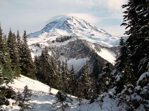
Though the peak looks quiet intimidating from below the way up to the summit is only mostly a walkup to the true summit. With a total roundtrip distance of 4 miles and only 1500 feet of elevation gain this peak can easily be done in a half day. The payoff for the half day of work is very impressive views of Rainier as well as views of Stuart, Baker, and Mount Saint Helens along with hundreds of other peaks in the region.

One thing to note about this route. It is a bootpath so when there is snow in either early summer or late fall, the path can easily be lost. For me the result was a Class 2 plus scramble at the very top. From all literature in summertime this is basically a walk-up so be aware of the trail conditions before you attempt this peak.

Getting There

VIA THE MOWICH LAKE AND TOLMIE PEAK TRAILHEAD (RECOMMENDED IN SUMMER. KEEP IN MIND THAT THE MOWICH LAKE ROAD IS CLOSED USUALLY TO AT LEAST MAY AND MANY TIMES MUCH LATER!!!!): Take Route 165 South. It will soon intersect with Route 162. Continue on Route 165 south through the towns of Wilkeson and Carbonado. You then go over an older bridge ove the Carbon River. This bridge is beginning to look unsteady and would not be a good place to be during an earthquake. Roughly a half mile over the bridge you will run into an intersection with one road veering right and head up Mowich Lake Road. You want to head up 17 miles up the road. You will run into the self pay area up at the Paul Peak Trailhead about 11 miles up the road. Don't forget to stop here because there are plenty of ranger at the Lake Mowich Campground and they will ticket you if you don't pay.
Route Description
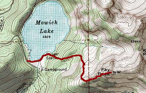
From the Mowich Lake Trailhead travel about 0.3 miles until you reach a ranger's cabin. From there look for an obvious bootpath unmaintained trail up from the cabin. This is considered by many as the Knapsack Pass Trail. It is unmaintained but still well traveled.

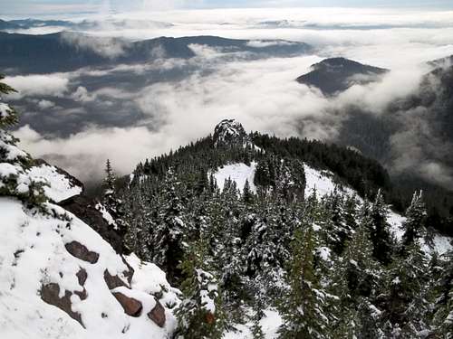
Continue up this bootpath roughly a half mile until you hit a small creek with a waterfall. Carefully look for bootpath on your right just before you hit the stream. You will know you missed it if you hit an open scree field to your right. Stay on the bootpath all of the up to the ridge. Once on the ridge go up to the left of a subpeak that back onto the ridge. From there follow the bootpath up the ridge and all the way to the summit rocks. Once on top take a look at the beautiful views of Mount Rainier and others in the area. In order to get back descend the way you came up.
Essential Gear
In summer and fall provided the snow melts nly essential hiking gear is needed. However in the shoulder seasons of early summer and late fall prepare with an ice axe, crampons, and/or other traction devides if needed. This route is only recommended in summer because in fall or winter the end section to the true summit of Fay Peak can be quiet dicey.External Links
A trip report on Fay PeakAnother TR on Fay Peak